Report on Guagua Pichincha (Ecuador) — September 1998

Bulletin of the Global Volcanism Network, vol. 23, no. 9 (September 1998)
Managing Editor: Richard Wunderman.
Guagua Pichincha (Ecuador) Phreatic discharges and shallow, near-vent seismicity continue
Please cite this report as:
Global Volcanism Program, 1998. Report on Guagua Pichincha (Ecuador) (Wunderman, R., ed.). Bulletin of the Global Volcanism Network, 23:9. Smithsonian Institution. https://doi.org/10.5479/si.GVP.BGVN199809-352020
Guagua Pichincha
Ecuador
0.171°S, 78.598°W; summit elev. 4784 m
All times are local (unless otherwise noted)
The volcanic crisis near Quito (figure 10) continued with a series of phreatic discharges and an E-dipping zone of earthquakes that rose to within a few kilometers of the surface (figure 2). With potentially dramatic significance to Ecuador's Capital (1995 urban population, 1,270,000 residents; suburban, 258,000 residents), the eruption has spurred a strong educational response in both the regional press and on an official web site. These discourses have repeated noteworthy points: the volcano's last vigorous eruption was in 1660; its recurrence intervals have oscillated between about 400 and 600 years; its last major eruption took place 338 years ago; and its phreatic eruptions have repeated during the past 15 years. Phreatic eruptions began on on 7 August (BGVN 23:08); since then the Instituto Geofísico, Escuela Politécnica Nacional (IG-EPN) has made available daily reports on activity during 30 September to 27 October, which we summarize here.
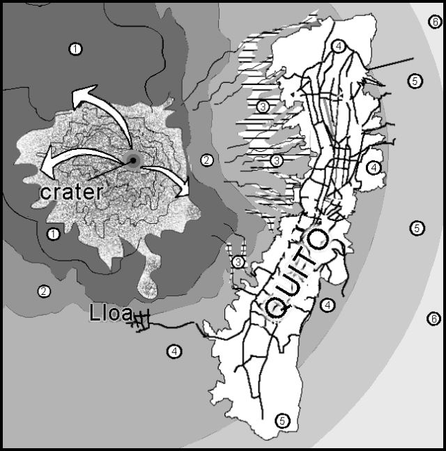 |
Figure 10. Simplified schematic showing Guagua Pichincha, Quito's urban areas (elongate zone with selected roads), and hazard designations associated with the volcano. Revised from a color hazard map on the IG-EPN website and keyed as follows: 1) Maximum danger (including major risks of hot volcanic flows, lahars, and ashfall - requiring total evacuation); 2) Minor danger (minor risk of ash clouds, hot volcanic flows, and lahars - areas immediately abandoned should an eruption be either imminent or large); 3) Lahar risk along drainage areas; and 4-6) graded risk of ashfalls. The bold arrows help identify the location of source vents and portray ejecta trajectories representative of those that might occur during an eruption. For more detail, see Hall and von Hillebrandt (1988). Courtesy of the Instituto Geofisico, Escuela Politécnica Nacional. |
Activity and observations. The epicenters of located earthquakes during April-October 1988 generally clustered around the caldera (figure 11). This was particularly the case for volcano-tectonic (VT) earthquakes, which in cross-section view tended to lie underneath the caldera. The located long-period (LP) events generally propagated from greater depths and in cross-section view defined a broad E-dipping zone. Thus far in the crisis there has been an alternating pattern of seismicity and seismically detected explosions (figure 12). During late September through late October there were often 1-2 daily explosions.
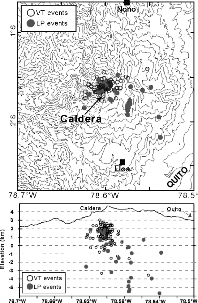 |
Figure 11. (top) Located seismic events at Guagua Pichincha during April-October 1998 were mainly centered around the caldera. The abbreviations VT and LP refer to volcano-tectonic and long-period events. The LP events showed a tendency to lie farther outboard, on the volcano's E slopes. (bottom) A cross section showing hypocenters for the same seismic events, which reveals the E-dipping attitude of located events. Courtesy of the Instituto Geofisico, Escuela Politécnica Nacional. |
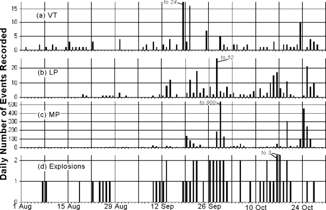 |
Figure 12. Histograms for Guagua Pichincha showing both the daily number of earthquakes, including (a) volcano tectonic (VT), (b) long-period (LP), (c) multiphase (MP), and (d) the daily number of seismically detected explosions. Courtesy of the Instituto Geofisico, Escuela Politécnica Nacional. |
On 3 October observers confirmed the presence of new fumaroles on the dome's W edge; nearby, in the headwaters of the Rio Cristal, they noted a new fumarole field. A phreatic explosion was heard at 0400 on 5 October by residents of Lloa. The explosion was the thirty-first such event in the sequence initiated on 7 August. It ranked among the most energetic seen to this point of the crisis, comparable to those on 8 and 24 August, and 29 September. The 5 October explosion followed 50 minutes of tremor registered at station YANA (7 km NE of the crater; "C" on figure 13). Small seismic events continued until 0800 that day. This explosion left a fresh ash layer in the caldera that revealed a new vent near the older one but above it to the S.
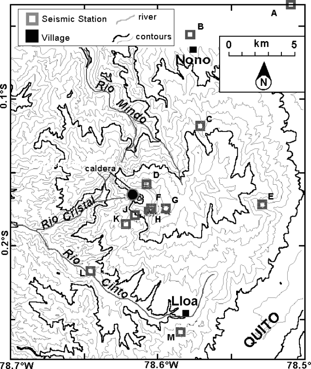 |
Figure 13. Contour map (200-m interval) indicating noteworthy sites surrounding Guagua Pichincha, including the valley embracing Quito and some of the key W-slope rivers that drain the breached caldera and environs. The map indicates settlements of Nono and Lloa (darkened rectangles) and seismic stations installed and maintained by various groups (open rectangles). These stations are designated by the following call letters: A, FARH; B, NONO; C, YANA; D, PINO; E, QWR; F, TERV; G, GGP; H, (uncertain); J, TOAZ; K, PIEZ; L, JORG; and M, MGUL. Courtesy of the Instituto Geofisico, Escuela Politécnica Nacional. |
The seismic swarm NE of the caldera (BGVN 23:08) continued; between June and early October there were 3,200 events; ~10 had a magnitude (MR) over 3.9. On 4 October instruments detected ~30 earthquakes, the strongest MR 3.5. A MR 3.6 earthquake struck this zone on 10 October and was felt locally in the settlements of Pomasqui and San Antonio.
Measured deformation was not detected for the interval 15 September-7 October. Although not plotted, tremor has occurred. For example, at 2214 on 7 October station PINO detected tremor for 19 minutes while station YANA registered it for 7 minutes. On 11 and 12 October tremor followed phreatic explosions and in the former case, prevailed for 20 minutes at stations near the crater.
Mass wasting on the SE flank ~11 km from the caldera (in Quito's San Roque sector) on 9 October covered an old school, part of a church, threatened several smaller structures, and blocked vehicular traffic. Roughly 20 people were evacuated.
On 12 October condensing gases escaping the dome at a fumarole called "La Locomotora" rose 200 m. Around this time the 1981 explosion crater also emitted a moderate flow of gray gases but new fractures or fumaroles were absent.
At 1621 on 14 October a phreatic explosion at the 1981 vent sent fine material over the NE part of the caldera and left a visible coating ~300 m up the caldera walls. The associated grayish-white plume formed a ~3-km-tall column. Clear weather enabled residents of Quito to see the plume. Geophysical instruments detected the event at widely scattered locations. COSPEC registered the first clear SO2 signal, a 300 ppm concentration in the plume. Guards at a local observation post smelled strong sulfur, particularly when gases from La Locomotra fumarole blew past.
An explosion at 0947 on 16 October sent a plume to ~2 km. Again, Quito residents saw the plume, but an explosion the next morning was shrouded from view by weather clouds. The latter explosion was considered moderate; it was associated with ~5 minutes of tremor centered around 1.2-Hz frequency and scientists working nearby (at station PINO) saw a gray-white cloud develop. A 17 October explosion was shrouded in clouds. The phreatic explosions on 14, 15, 16, and 17 October yielded respective reduced seismic displacements of 11, 4.2, 9.8, and 3.2 cm2.
A view into the caldera on the morning of 18 October disclosed relatively passive outgassing from the 1981 and 1988 explosion craters. La Locomotra and other fumaroles on the central dome had clearly increased their output, feeding a plume ~700 m high. Another moderate explosion on 25 October was followed by 3 hours of tremor.
A flight on the morning of 27 October revealed only modest degassing, a 300-m-high plume, and an SO2 concentration below the COSPEC's detection limit. Minard Hall also recognized that the 1981 crater and one formed in September 1998 had coalesced. The wall isolating them had apparently been weakened by repeated phreatic eruptions.
Risk mapping. The highest risk settlements include Lloa (figures 1 and 4) and Mindo. The latter lies on the river of the same name about 22 km NW of the caldera; it lies off of maps in this report but is depicted on the larger hazard map of Hall and von Hillebrandt (1988). One branch of the Mindo river's headwaters begin just N of the breach in the caldera (figure 4). Rivers draining the breached W-flank and nearby NW-flank (e.g. Rio Cristal and Rio Mindo) were assigned a higher category of risk for lahars than any lahar-risk zones on the E flanks (figure 1).
New fieldwork has been aimed at inspecting older lahar deposits in vicinity of the settlements of Mindo and Nono. Nono, on the NNE flank (figures 2 and 4), lies at mouth of a narrow N-S valley that cuts across much of the volcano's E to NNE flanks.
Partnerships. The following describes some of the civic and media efforts to communicate volcanic hazards. On 30 September Ecuador's president requested that a safety committee be formed (Comité Especial de Seguimento, CES). The committee was charged with integrating Civil Defense, the IG-EPN, and the City of Quito. In overcast conditions on 24 August a film crew from TeleAmazonas shot footage of an explosion plume not otherwise visible in Quito. These glimpses, and later examples of widely visible plumes, surely helped residents grasp the immediacy and some of the power of the eruption.
Authorities raised the hazard status to Yellow on 1 October. On 3 October a new video system started to monitor the inner crater. This advance was supported by "Ecuavista" in coordination with "911 of the City of Quito," the phone number for the City's communications base.
A 2 October announcement told of a downtown Quito information center implemented to release daily circulars at bearing official volcanological information. Thanks to a partnership between the information center and IBM of Ecuador, the former gained access to the internet, email, and a modern computing environment The radio station "Zaracay," which can be received widely, including the urban and Mindo areas, was also designated as a conduit for public announcements.
By 7 October the seismic network consisted of 12 stations with real-time data transmission. Collaborating scientific teams and monitoring equipment have come from both the U.S. Geological Survey as well as ORSTOM (the French Scientific Research Institute for Development through cooperation). Contingency plans have surfaced, dealing with the issue of transportation during the higher stages of alert (Orange and Red). Public announcements have broached the need to maintain the integrity of the municipal infrastrucure in the event of an eruption, including crews to clean ash (from roads, power lines, etc.).
Reference. Hall, Minard, and von Hillebrandt M., Christa G., 1988, Mapa de los peligros volcanicos poteciales asociados con el volcan Guagua Pichincha; Republica del Ecuador (1:50,000).
Geological Summary. Guagua Pichincha and the older Pleistocene Rucu Pichincha stratovolcanoes form a broad volcanic massif that rises immediately W of Ecuador's capital city, Quito. A lava dome grew at the head of a 6-km-wide scarp formed during a late-Pleistocene slope failure ~50,000 years ago. Subsequent late-Pleistocene and Holocene eruptions from the central vent consisted of explosive activity with pyroclastic flows accompanied by periodic growth and destruction of the lava dome. Many minor eruptions have been recorded since the mid-1500's; the largest took place in 1660, when ash fell over a 1,000 km radius and accumulated to 30 cm depth in Quito. Pyroclastic flows and surges also occurred, primarily to then W, and affected agricultural activity.
Information Contacts: Instituto Geofísico, Escuela Politécnica Nacional, Apartado 17-01-2759, Quito, Ecuador; El Comercio newspaper, Quito, Ecuador (URL: http://www.elcomercio.com); El Universo newspaper, Quito, Ecuador (URL: http://www.eluniverso.com); La Hora newspaper, Quito, Ecuador (URL: http://www.lahora.com); Volcanic Disaster Assistance Program, U.S. Geological Survey, 5400 MacArthur Blvd., Vancouver, Washington 98661 USA (URL: https://volcanoes.usgs.gov/observatories/cvo/); ORSTOM, A.P. 17-11-6596, Quito, Ecuador (URL: http://www.ird.fr/).