Report on Cerro Azul (Ecuador) — September 1998
Bulletin of the Global Volcanism Network, vol. 23, no. 9 (September 1998)
Managing Editor: Richard Wunderman.
Cerro Azul (Ecuador) Flank and caldera eruptions continue
Please cite this report as:
Global Volcanism Program, 1998. Report on Cerro Azul (Ecuador) (Wunderman, R., ed.). Bulletin of the Global Volcanism Network, 23:9. Smithsonian Institution. https://doi.org/10.5479/si.GVP.BGVN199809-353060
Cerro Azul
Ecuador
0.92°S, 91.408°W; summit elev. 1640 m
All times are local (unless otherwise noted)
This eruption began between 1229 and 1304 on 15 September (BGVN 23:08). The event was first recognized by University of Hawaii scientists monitoring thermal images from the GOES-8 geostationary satellite. A dominant plume reaching over 150 km SW developed between 1345 and 1545 on 15 September, and a minor plume trended NW carried by the prevailing surface winds. Overflights revealed two new vents in the summit caldera, and a flank fissure eruption 8 km SE of the caldera (figure 1).
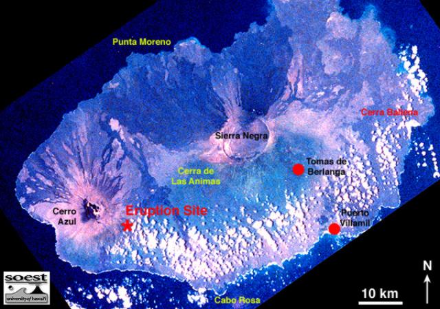 |
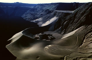
Figure 1. Photograph of the S part of Isabela Island, taken from the Space Shuttle in 1983, showing the site of the September 1998 flank eruption. Puerto Villamil and the scientific station at Tomas de Berlanga (or Santo Tomas) are the only inhabited locations on the island. White zones over the island are clouds. Courtesy of the GOES Hotspot Monitoring System. |
The first scientists reaching the volcano were from Ecuador's Instituto Geofísico-Escuela Politécnica Nacional (IG-EPN) and ORSTOM. They described the flank eruption site as a SE-directed radial fissure, 400-500 m long, and between 680 and 630 m elevation. Lava fountaining (to ~200 m) built an elongate cinder cone 50 m high during the team's 19-25 September observations. The main cone was breeched on the E, issuing flows that traveled over 8 km E before turning S toward the sea. During the night of 24-25 September a break in the main cone fed a new flow to the SE. All were 3-5-m-thick aa flows, and the longest ended 2 km from the coast.
University of Idaho graduate student Rachel Ellisor arrived on the night of 22 September, and described additional details of the flank eruption, including a smaller cone (NW of the main cone) with low fountains feeding a flow moving more directly S toward the sea. This flow was sampled daily; its velocity ranged from 0.001 to 10-20 km/hour and its thickness was described as 2-3 m at the front but 10-12 m in the interior. Gas clouds billowed from the fissure's SE end, and fountains issued from the main vent.
Ellisor took a 1 October overflight and described the intracaldera flows. One issued from a small vent (20-30 m high) on the S bench and flowed NW onto the caldera floor, while a larger cone (~60 m high) on the W caldera floor fed flows eastward into the shallow lake. Intracaldera activity had ended by 1 October.
Returning to the flank eruption, Ellisor reported that three large cones (60-80 m high) had been built in a N-S orientation. The mid-September flows (to the E, then S) had stagnated on the coastal flats, and their thickness was estimated at 5-15 m (interior) to 1-3 m (fronts). Increased activity on 6 October fed new flows building a channel system directly S of the main fissure. Ellisor's most recent report was dated 13 October, but GOES-8 images showed a thermal anomaly continuing through 4 November, the eruption's 51st day.
During 19-25 September, scientists from IG-EPN and ORSTOM installed three digital and one analog seismic station between the coast and the active vent. The distance between end stations was 8.5 km. Seismic signals registered during the study were composed of permanent tremor with an amplitude of 20 µm/s (2.4 km from the vent) and with a dominant frequency of 1.6 Hz. No rock-fall or long-period events were registered. One station 4 km from the vent continued working after the group returned to Quito.
Geological Summary. Located at the SW tip of the J-shaped Isabela Island, Cerro Azul contains a steep-walled 4 x 5 km nested summit caldera complex that is one of the smallest diameter, but at 650 m one of the deepest in the Galápagos Islands. The shield volcano is the second highest of the archipelago. A conspicuous bench occupies the SW and west sides of the caldera, which formed during several episodes of collapse. Youthful lava flows cover much of the caldera floor, which has also contained ephemeral lakes. A prominent tuff cone located at the ENE side of the caldera is evidence of episodic hydrovolcanism. Numerous spatter cones dot the western flanks. Fresh-looking lava flows, many erupted from circumferential fissures, descend the NE and NW flanks. Historical eruptions date back only to 1932, but Cerro Azul has been one of the most active Galápagos volcanoes since that time. Solfataric activity continues within the caldera.
Information Contacts: P. Samaniego, F. Desmulier, J.P. Metaxian, M. Ruiz, and M. Vaca, Instituto Geofísico, Escuela Politécnica Nacional, AP 17-01-2759, Quito, Ecuador; ORSTOM (L'Institut Français de Recherche Scientifique pour le Développement en Coopération), AP 17-11-6596, Quito, Ecuador (URL: http://www.ird.fr/); Rachel Ellisor and Dennis Geist, Dept. of Geology and Geological Engineering, University of Idaho, Moscow, ID 83843 USA (URL: https://www.uidaho.edu/sci/geology/); Peter Mouginis-Mark and Luke Flynn, GOES Hotspot Monitoring System, Hawaii Institute of Geophysics and Planetology, University of Hawaii, 2525 Correa Road, Honolulu, Hawaii 96822 USA (URL: http://modis.higp.hawaii.edu/).