Report on Ambae (Vanuatu) — October 1998

Bulletin of the Global Volcanism Network, vol. 23, no. 10 (October 1998)
Managing Editor: Richard Wunderman.
Ambae (Vanuatu) Monitoring and water chemistry at Voui crater lake
Please cite this report as:
Global Volcanism Program, 1998. Report on Ambae (Vanuatu) (Wunderman, R., ed.). Bulletin of the Global Volcanism Network, 23:10. Smithsonian Institution. https://doi.org/10.5479/si.GVP.BGVN199810-257030
Ambae
Vanuatu
15.389°S, 167.835°E; summit elev. 1496 m
All times are local (unless otherwise noted)
Following the 1995 phreatic explosion at Lake Voui (BGVN 20:02 and 20:08) a bathymetric survey of the crater lake was carried out. The 1996 survey confirmed the location of activity that had first been observed in 1992 on a SPOT satellite image. Monitoring of Lake Voui has continued through November 1998.
The average temperature over the whole 1 x 2 km surface of the lake (figures 7 and 8) stayed at ~30°C during November 1996-November 1998, due in part to constant streams of gas that issued from the main vent. As a comparison, in June 1995, three months after the phreatic explosion, the surface temperature was 45°C.
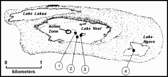 |
Figure 7. Schematic map of the summit area of Aoba volcano. Monitoring equipment includes: (1) a hydrophone at a depth of 10 m; (2) temperature sensors at a depth of 7 m; (3) power supply, electronics, and ARGOS satellite transmitter station; and, (4) a terrestrial data station measuring seismicity, heat flow, and rainfall. Courtesy Centre ORSTOM, Vanuatu. |
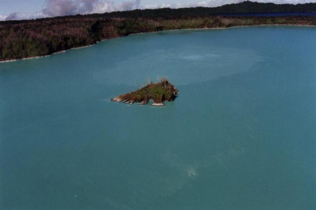 |
Figure 8. Photograph of Aoba showing Lake Voui. Water discoloration marks the zone of activity. The power and transmitter station is located on the islet at the center. Lake Lakua is in the right background. Courtesy Centre ORSTOM, Vanuatu. |
The ten major compounds dissolved in the lake's water have changed in concentration with time (table 1), but the samples, taken at the surface and at depths of 15-50 m, were consistent throughout the lake at any one time.
Table 1. Synopsis of the physical and chemical analysis of the waters of Voui lake derived from samples taken during 1995-98. Chemical constituents and ratios are given in mg/L. Courtesy Centre ORSTOM, Vanuatu.
| Date | pH | Conductivity (mS) | Temp.(°C) | Cl | SO4 | SO4/Cl | Mg | Mg/Cl | Ca | Na | K | Fe | Mn | Al |
| 27 Jun 1995 | 2.2 | 19.5 | 40 | 3240 | 8560 | 2.6 | 1910 | 0.589 | 288 | 1030 | 440 | 425 | 74 | 75 |
| 01 Dec 1995 | 2.3 | 18.9 | 35 | 2700 | 8350 | 3.1 | 1840 | 0.681 | 193 | 1030 | 317 | 253 | 65 | 39 |
| 01 May 1996 | 2.0 | 21.4 | 35 | 2560 | 9900 | 3.9 | 2190 | 0.858 | 230 | 1110 | 307 | 274 | 69 | 41 |
| 25 Nov 1996 | 1.5 | 28.8 | 30 | 2530 | 9510 | 3.8 | 2140 | 0.848 | 174 | 810 | 219 | 246 | 64 | -- |
| 17 Jun 1997 | 1.1 | 33.2 | 30 | 2410 | 13130 | 5.4 | 2100 | 0.872 | 160 | 690 | 161 | 252 | 56 | 62 |
| 30 Nov 1997 | 1.3 | 36.9 | 30 | 2280 | 15260 | 6.7 | 2150 | 0.942 | 130 | 520 | 113 | 304 | 54 | 60 |
| 19 Jul 1998 | 1.4 | 34.4 | 30 | 2100 | 18010 | 8.6 | 1802 | 0.859 | 42 | 521 | 97 | 287 | 50 | 77 |
The average volume of the lake was estimated at 50 x 106 m3, but the level varied significantly. A drop of 275 cm in surface elevation was observed between June 1997 and October 1998. Rainfall varied between 500 and 600 cm/year in the summit area.
Monitoring was conducted twice per year, complemented by seismic recordings taken from a station set up in the dry lake bed of Ngoro. This system is similar to that used on Tanna Island, Vanuatu (BGVN 21:08). The range of monitoring equipment in place on Aoba since 1996 was extended in October 1998 by the installation of an acoustic recording station (0.1-150 KHz) and a device for continuous measurement of lake-water temperature. The data are relayed through an ARGOS satellite transmitter. Identical stations have been set up on Kelut in Indonesia and at Lake Taal in the Philippines.
Geological Summary. The island of Ambae, also known as Aoba, is a massive 2,500 km3 basaltic shield that is the most voluminous volcano of the New Hebrides archipelago. A pronounced NE-SW-trending rift zone with numerous scoria cones gives the 16 x 38 km island an elongated form. A broad pyroclastic cone containing three crater lakes (Manaro Ngoru, Voui, and Manaro Lakua) is located at the summit within the youngest of at least two nested calderas, the largest of which is 6 km in diameter. That large central edifice is also called Manaro Voui or Lombenben volcano. Post-caldera explosive eruptions formed the summit craters about 360 years ago. A tuff cone was constructed within Lake Voui (or Vui) about 60 years later. The latest known flank eruption, about 300 years ago, destroyed the population of the Nduindui area near the western coast.
Information Contacts: Michel Lardy, Inès Rodriguez, Douglas Charley, and Pascal Gineste, Centre ORSTOM, P.O.Box 76, Port-Vila, Vanuatu; Michel Halbwachs, and Jacques Grangeon, Université de Savoie, Campus Scientifique, F3376, Le Bourget du Lac, Cédex France; Janette Tabbagh, Centre de Téléobservation Informatisée des volcans, CNRS-CRG, Garchy, France.