Report on Deception Island (Antarctica) — January 1999
Bulletin of the Global Volcanism Network, vol. 24, no. 1 (January 1999)
Managing Editor: Richard Wunderman.
Deception Island (Antarctica) Increased level of seismicity detected
Please cite this report as:
Global Volcanism Program, 1999. Report on Deception Island (Antarctica) (Wunderman, R., ed.). Bulletin of the Global Volcanism Network, 24:1. Smithsonian Institution. https://doi.org/10.5479/si.GVP.BGVN199901-390030
Deception Island
Antarctica
62.9567°S, 60.6367°W; summit elev. 602 m
All times are local (unless otherwise noted)
Deception Island has been monitored during every austral summer since 1987. In December 1998, a new seismic network was deployed to monitor activity at Deception as part of the Spanish Antarctic Research Project. The following is a preliminary report on findings of the project. A final, comprehensive report will be finished in March 1999.
Significant seismic episodes, including several kinds of seismic signals, were recorded during the period 3-24 January. In summary there were 720 volcano-tectonic earthquakes, 417 long-period events, and volcanic tremor lasting 20 hours. Most of the earthquakes had magnitudes close to one, and only six had magnitudes more than three. Two earthquakes were felt by the Spanish team working at the Spanish Antarctic Station "Gabriel de Castilla" on Deception Island. These occurred on 10 January (M 3.3) and 20 January (M 4.3), and both were located in the NE of the island. Seismic events are recorded, quantized, and located on the island by Spanish researchers who regularly send back information. They suggest January's activity has been at a higher level than during any previous survey, with the exception of levels recorded during the 1991-92 campaign (BGVN 17:04). The temperatures of anomaly areas (fumaroles and thermal soils) have been periodically measured, but no significant variation has been detected.
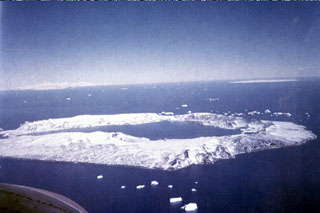
Geological Summary. Ring-shaped Deception Island, at the SW end of the South Shetland Islands, NE of Graham Land Peninsula, was constructed along the axis of the Bransfield Rift spreading center. A narrow passageway named Neptunes Bellows provides an entrance to a natural harbor within the 8.5 x 10 km caldera that was utilized as an Antarctic whaling station. Numerous vents along ring fractures circling the low 14-km-wide island have been reported active for more than 200 years. Maars line the shores of 190-m-deep Port Foster caldera bay. Among the largest of these maars is 1-km-wide Whalers Bay, at the entrance to the harbor. Eruptions during the past 8,700 years have been dated from ash layers in lake sediments on the Antarctic Peninsula and neighboring islands.
Information Contacts: Alicia Garcia and Ramon Ortiz, Dpto. de Volcanologia, M.N.C.N.-C.S.I.C. Jose Gutierrez Abascal 2, 28006 Madrid, Spain; Jesus Ibañez, Gerardo Alguacil, and Jose Morales, Instituto Andaluz de Geofísica, Univ. Granada, Spain; Edoardo del Pezzo, Osservatorio Vesuviano, Napoli, Italy; Javier Almendros, Enrique Carmona, Jose Peña, and Gilberto Sacorotti, Spanish Antarctic Station "Gabriel de Castilla," Deception Island.