Report on Pacaya (Guatemala) — February 1999

Bulletin of the Global Volcanism Network, vol. 24, no. 2 (February 1999)
Managing Editor: Richard Wunderman.
Pacaya (Guatemala) Explosive activity resumes; summary of activity 1987-98
Please cite this report as:
Global Volcanism Program, 1999. Report on Pacaya (Guatemala) (Wunderman, R., ed.). Bulletin of the Global Volcanism Network, 24:2. Smithsonian Institution. https://doi.org/10.5479/si.GVP.BGVN199902-342110
Pacaya
Guatemala
14.382°N, 90.601°W; summit elev. 2569 m
All times are local (unless otherwise noted)
Explosive activity resumed on 2 January 1999 at Pacaya for the first time since the end of a major eruptive episode on 19 September 1998. Current activity has consisted of small explosions that ejected ash without incandescent material. Beginning on 8 January, the number of explosions increased from 100-200/day to more than 400/day, reaching a peak of ~ 550 on 21 January (figure 19). Explosion counts declined to ~200/day by the end of the month. Volcanologists from INSIVUMEH and the Smithsonian Institution observed frequent small ash eruptions during a 1 February visit. The explosions were not accompanied by detonations, and produced billowing gray-to-brown ash columns that rose ~100 m above the vent. They observed that two vents produced explosions; the largest explosions originated from the westernmost and lower of two vents in the breached crater. Intense fumarolic activity occurred from the inclined floor of the summit crater, its rim, and the outer flanks.
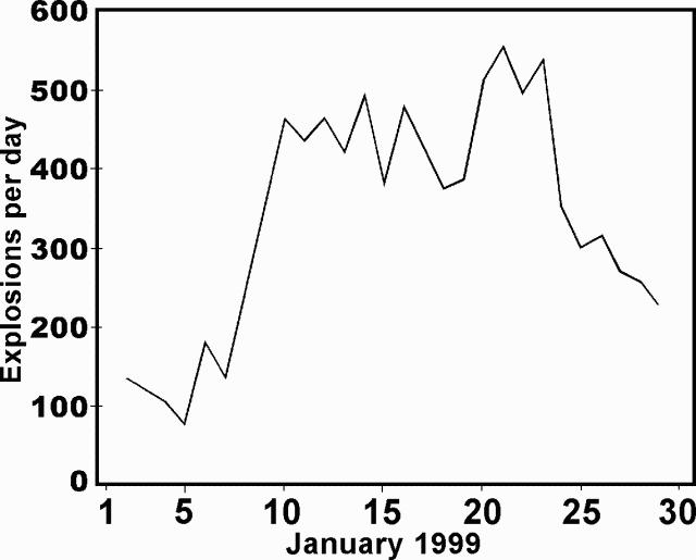 |
Figure 19. Daily explosion counts at Pacaya during January 1999. Courtesy of INSIVUMEH. |
Significant changes to the morphology of MacKenney cone had occurred since a strong explosive eruption on 18-19 September 1998. That eruption left a major breach 20-25 m wide that extended SW. By the time of the 1 February visit, erosion had widened the breach to 70-80 m. At its head, the breach had nearly vertical walls more than 50 m deep, and formed a gully that extended more than 1 km down to ~1,800 m elevation. The NE side of the crater was also notched, but not nearly as deeply. Fractures and down-dropped blocks of summit agglutinate material along the crater rim also showed this SW-NE orientation in line with the location of two flank vents active during September 1998. The breach gives MacKenney cone a twin-peaked appearance when viewed from the W flank (figure 20). The present form of the crater increases the possibility of future eruptive or collapse events being directed toward the W-flank village of El Patrocinio (figure 21).
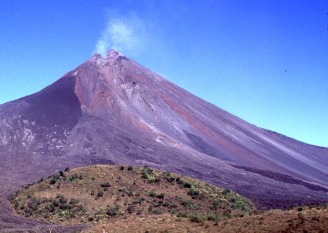 |
Figure 20. A prominent gully extends more than 1 km down the SW flank of Pacaya from the twin-peaked summit of MacKenney cone, 1 February 1999. The dark lava flow at the lower right was one of two emplaced from flank vents at the end of the 18-19 September 1998 eruption. Photograph courtesy of Lee Siebert. |
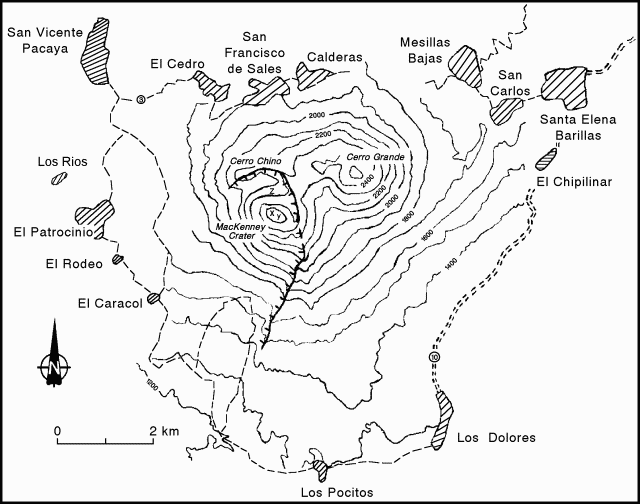 |
Figure 21. Sketch map of Pacaya and nearby towns. Hachured arcuate line indicates the caldera rim. Contour interval 100 m; contour intervals around MacKenney crater are approximate. Courtesy of INSIVUMEH. |
The accumulation of spatter and ejecta from the September 1998 explosions had built MacKenney cone to a height about 30-35 m above an older cone immediately SE of MacKenney crater. The older cone, the previous vantage point for observing explosive activity from Pacaya, had itself grown about 10 m in the past decade from the accumulation of ejecta from MacKenney crater. The height of MacKenney cone now exceeds that of Cerro Grande, a vegetated ~2,560-m-high prehistorical cone of Pacaya located 2 km NE of MacKenney.
September 1998 eruption. A major explosive and effusive eruption took place on 18-19 September (table 3). During the first 17 hours of the eruption, a 1.2-km-long lava flow descended WNW into the caldera moat and down the flank of the volcano to the Montanas las Granadillas area SW of Cerro Chino. From 1700-2200 an explosive eruption ejected ash columns to 5 km above the crater, producing ashfall to the SW and NNW. Fine ashfall caused the closing of the international airport in Guatemala City for 35 hours. About 1 m of volcanic bombs were deposited on the caldera rim. Pyroclastic avalanches of incandescent ejecta mantled the upper half of the cone. One 3-m-wide impact crater was formed at the base of the lava flow near El Patrocinio, and 1-m-wide impact craters were found as far as 5 km from the vent. During the final explosive phase, the SW rim of MacKenney crater collapsed, forming a debris avalanche that traveled 2 km down the SW flank to ~1,500 m elevation. Coarse blocks littered the surface of the deposit, whose light color contrasted with that of adjacent dark-colored lava flows.
Table 3. Summary of major eruptive events at Pacaya volcano from January 1987 to September 1998.
| Date | Description of Volcanic Activity |
| 21 Jan 1987 | Ash fell over areas of the villages of Amatitlan and Santa Elena Barillas. The villages of El Caracol and El Patrocinio were evacuated. |
| 25 Jan 1987 | 10-15 cm of ash fell over El Caracol, El Rodeo, and in part over El Patrocinio. |
| 14 Jun 1987 | Lava flow reached 2.5 km SW; 600 people evacuated. |
| 7-11 Mar 1989 | Two lava flows threatened to reach El Patrocinio and El Rodeo. A third lava flow traveled 3 km on the W flank. |
| 02 Apr 1990 | A 4-hour-long eruption deposited 10 cm of ash in El Patrocinio and El Caracol. |
| 15 Sep 1990 | Moderate intensity eruption caused a moderate ash fall over El Patrocinio. |
| 05 Mar 1991 | Minor ashfall in El Caracol and El Patrocinio. |
| 06, 14, 16 Jun 1991 | Continuing eruptive activity destroyed the active crater (MacKenney). |
| 08, 12, 14, 15 Jul 1991 | Moderate intensity eruption; minor ashfall over El Caracol (3 km from the crater). |
| 27 Jul 1991 | An eruption caused a 26-cm-thick ash layer to be deposited over El Caracol and El Patrocinio, 1.5 cm in Escuintla, and a thin layer in Santa Lucia Cotzumalguapa. |
| 01 Aug 1991 | A 3,000-m-high column caused ashfall over Barbarena and Cuilapa. |
| 10 Jan 1993 | Collapse in the active crater sent a glowing avalanche to the side of El Caracol. The post-collapse eruption column drifted toward Santa Lucia Barillas. The acidity of the ash damaged vegetation in the region. |
| 21 Sep 1993 | 4-hour eruption caused a minor ashfall over El Caracol. |
| 16 Mar 1994 | Eruption lasted until midnight and had an incandescent lava fountain 300 m high. Most of the ash fell on the volcano's flanks. |
| 15 Oct 1994 | Phreatomagmatic explosion; acid ashfall damaged vegetation in Santa Elena Barillas and Los Llanos. Population was affected by pulmonary and respiratory problems. |
| 07 Apr 1995 | A lahar completely covered a house and killed a little girl in Los Rios. The inhabitants were evacuated as 25-35-cm-thick volcanic sand was deposited over the village. As a result of a hazard study, many villagers had been previously evacuated. |
| 01-07 Jun 1995 | A debris avalanche caused by collapse of the W crater rim destroyed a radio station and partially burned the vegetation of Cerro Chino in a 4-km2 area. |
| 07 Jun 1995 | Lahars moving as a dense, dough-like mass, cut roads and wiped away a bridge. Consequently many families in El Patrocinio and Los Rios were evacuated and later part of the population was relocated in La Colima. |
| 17 Sep 1995 | A 1-km-high column from a phreatomagmatic explosion deposited 3 cm of fine ash in Santa Elena Barillas and a fine veil of volcanic dust in Barbarena and near Cuilapa. |
| 11 Oct 1996 | At dawn the eruption produced a sustained lava fountain 500-700 m high and lava flows as long as 1.5 km on the SE flank. The 35 km/h wind with blasts at 45 km/h caused a fine ash fall as far as Puerto San Jose, 60 km to the S on the Pacific Ocean. |
| 11 Nov 1996 | A 9-hour-long eruption produced a 2-km long lava flow and deposited 7-12 cm of ash near El Caracol and Finca El Rabon. El Rodeo received a 2-3 cm thick blanket of ash. It was necessary to evacuate the population of El Caracol, El Rodeo, and some women and children of El Patrocinio. |
| 20 May 1998 | A 5-hour eruption produced a 4-km-high ash column. S wind caused ashfall in the capital City, Ciudad de Guatemala (2 mm in the N and 4 mm in the S areas of the city). La Aurora International airport was closed for three days. Incandescent bombs and hot blocks ignited trees in the mountainous areas of Cerro Grande, 2 km NNE of MacKenney crater. 254 people were evacuated from San Francisco de Sales, El Cedro, and El Pepinal. Two people were injured by falling scoriaceous bombs in S.F. de Sales. |
| 14 Jun 1998 | A moderate eruption began at 0600 and lasted until 1900. An incandescent lava fountain was oscillating between 150 and 400 m high. A large ash column (600-800 m high) was blown to the S and produced scoriaceous ashfall in El Caracol. There was no need to evacuate. Condensation of atmospheric humidity due to the heat fed a cloud that reached 1,500-1,700 m in height. The Unidad Coordinadora Deptal de Escuintla del Ministerio de Agricoltura, Ganaderia y Alimentacion reported the loss of Q70,000 (US $10,000) from partial destruction of coffee, corn, and bean crops, and for purchase of food for livestock. Aircraft reported ash at 5,500 m. |
| 18 Jun 1998 | A 10-minute explosion at 1045 caused the ejection of semi-incandescent blocks (>= 35 cm) over all the volcano flanks. Then, 20 minutes later, fine ash lightly fell over the city of San Vincente Pacaya. |
| 18 Sep 1998 | The main eruption had one effusive and one explosive phase. The first lasted 17 hours, producing a 1,200-m-long tongue of lava that emerged from the WNW rim of the active crater and then deviated to the Montanas las Granadillas area SW of Cerro Chino. The second phase occurred from 1700 to 2200 hours. It expelled an ash column that reached 5,000 m altitude and produced ash and lapilli fall to the SW and NNW.A very thin film of fine ash (~ 1 mm) caused the La Aurora International airport to be closed again for 35 hours, after which it reopened with restrictions. Three lava flows accompanied the explosive phase; the first one, 400 m long, went WNW and reached the base of the cone. There it joined the second flow (from the N flank). The third lava flow departed from the second flow and went to the S toward El Caracol. During the proximal explosive phase the SW rim of the MacKenney crater collapsed, causing a debris avalanche 2 km long, and a cloud of hot ash and gases that burned vegetation in the distal reaches. |
Several lava flows accompanied the explosive activity (figure 22). The longest of these traveled ~4 km from a notch in the NE crater rim. The flow initially descended northward into the caldera moat where it was deflected by the caldera wall, flowed across the moat, and then down the SW flank to 1,760 m elevation before diverging around a small kipuka and scorching trees at its northern margin below Cerro Chino. Much of the caldera moat was covered by lava flows of the September eruption, and the prominent 1984 spatter cone low on the N flank was nearly buried.
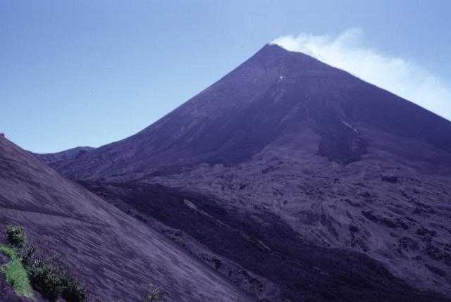 |
Figure 22. Photograph of the lava flow (foreground) that descended from Pacaya's caldera moat down the W flank. This flow and the two dark lobes above it originated from MacKenney cone during the 18-19 September 1998 eruption. Light-colored tephra deposits between the flows mantle previous lava flows. Photograph taken on 1 February 1999. Courtesy of Paul Kimberly, SI. |
At the end of the eruption, two small lava flows took place from flank vents on opposite sides of the cone. A vent on the upper NE flank at ~2,450 m elevation produced a short lava flow that reached the caldera moat. A vent on the lower SW flank at ~1,800 m elevation (figure 22) produced a short lava flow that divided into two lobes, one traveling to the SW and the other to the south.
Summary of 1987-1998 activity. Routine explosive activity characteristic of Pacaya occurred through much of the period from 1987 to the present but is not listed in table 3. Strong explosive eruptions in January 1987 and June 1991 destroyed the upper part of MacKenney cone, deepening and widening the crater, after which renewed eruptions reconstructed the cone. Major eruptions on 7 and 14 June 1995 destroyed the WNW side of the crater, leaving two notches at the summit. Debris from the 7 June collapse slammed into the caldera wall at Cerro Chino, 1 km NW of the summit, and produced a secondary hot cloud that swept over Cerro Chino, destroyed a radio antenna, and affected houses within 2 km of the active vent. The shockwave threw INSIVUMEH observer Pastor Alfaro down a slope, fracturing his leg. The 7 June event produced a 2.5-km-high plume. The second collapse on 14 June produced an avalanche that traveled SW toward El Rodeo and was accompanied by a 4-km-high plume. Lava flows subsequently traveled 2 km. Figure 23 shows RSAM plots for 1995-98.
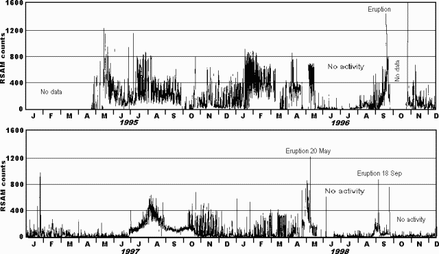 |
Figure 23. Plot of seismic activity at Pacaya as represented by Real-time Seismic Amplitude Measurement (RSAM) counts during January 1995-December 1998. Courtesy of INSIVUMEH. |
A strong explosive eruption on 20 May 1998 produced a 4-km-high ash column. Incandescent bombs burned trees on the SSW flank of Cerro Grande, 2 km N of the crater, and scoria fall damaged vegetation and crops. Two persons in the settlement of San Francisco de Sales, 2.5 km NE of the crater, were injured by falling scoria blocks. The ash plume was primarily blown to the NE, with a lesser plume to the SW (figure 24). Ash fell from 1300-1600 in the villages and towns within 5 km of the volcano. During 1400-1830 ash fell in the capital city of Guatemala, causing closure of the international airport. Ashfall covered an area of 800 km2, and had an estimated volume of ~2.3 x 10⁶ m3. The eruption caused the evacuation of 254 residents from surrounding villages to the town of San Vicente de Pacaya. Lava flows during the 20 May eruption traveled down the N, W, and SW flanks and had a volume of 6.3 x 10⁵ m3.
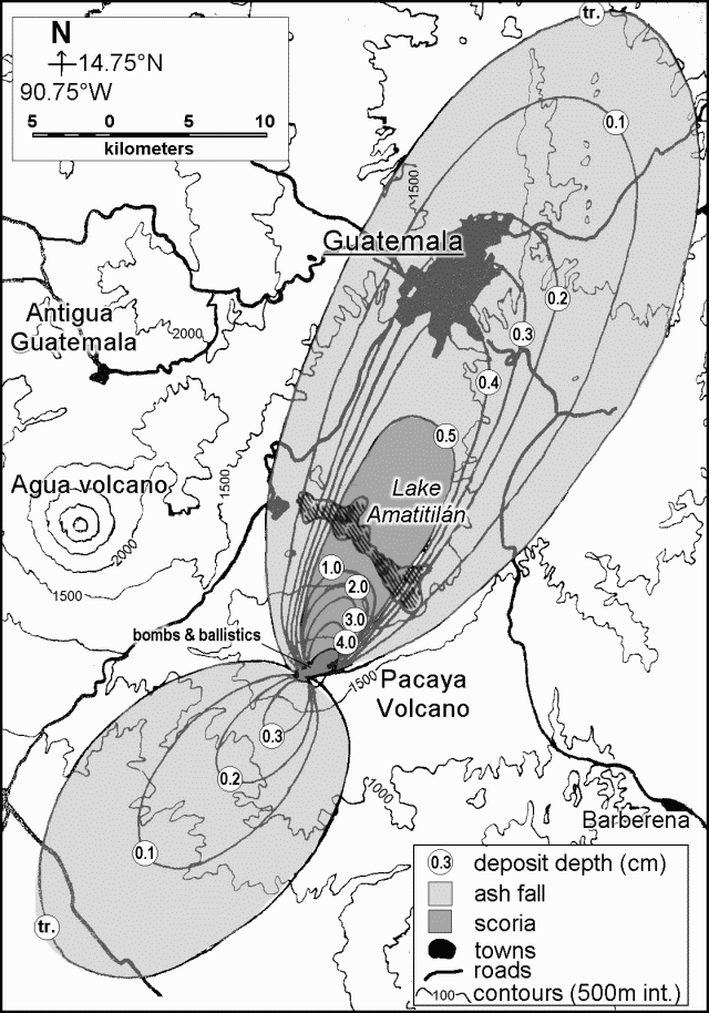 |
Figure 24. Isopachs of the 20 May 1998 explosive eruption from Pacaya volcano. Courtesy of Otoniel Matias, INSIVUMEH. |
Geological Summary. Eruptions from Pacaya are frequently visible from Guatemala City, the nation's capital. This complex basaltic volcano was constructed just outside the southern topographic rim of the 14 x 16 km Pleistocene Amatitlán caldera. A cluster of dacitic lava domes occupies the southern caldera floor. The post-caldera Pacaya massif includes the older Pacaya Viejo and Cerro Grande stratovolcanoes and the currently active Mackenney stratovolcano. Collapse of Pacaya Viejo between 600 and 1,500 years ago produced a debris-avalanche deposit that extends 25 km onto the Pacific coastal plain and left an arcuate scarp inside which the modern Pacaya volcano (Mackenney cone) grew. The NW-flank Cerro Chino crater was last active in the 19th century. During the past several decades, activity has consisted of frequent Strombolian eruptions with intermittent lava flow extrusion that has partially filled in the caldera moat and covered the flanks of Mackenney cone, punctuated by occasional larger explosive eruptions that partially destroy the summit.
Information Contacts: Otoniel Matias, Instituto Nacional de Sismologia, Vulcanologia, Meteorologia e Hydrologia (INSIVUMEH), Ministerio de Communicaciones, Transporte y Obras Publicas, 7A Avenida 14-57, Zona 13, Guatemala City, Guatemala; Lee Siebert and Paul Kimberly, Global Volcanism Program, National Museum of Natural History, Room E-442, Smithsonian Institution, Washington DC 20560-0119.