Report on Soufriere Hills (United Kingdom) — February 1999

Bulletin of the Global Volcanism Network, vol. 24, no. 2 (February 1999)
Managing Editor: Richard Wunderman.
Soufriere Hills (United Kingdom) Ash venting and numerous pyroclastic flows in December 1998 and January 1999
Please cite this report as:
Global Volcanism Program, 1999. Report on Soufriere Hills (United Kingdom) (Wunderman, R., ed.). Bulletin of the Global Volcanism Network, 24:2. Smithsonian Institution. https://doi.org/10.5479/si.GVP.BGVN199902-360050
Soufriere Hills
United Kingdom
16.72°N, 62.18°W; summit elev. 915 m
All times are local (unless otherwise noted)
Several small dome collapses, some that were initially explosive, generated pyroclastic flows in December. Episodes of ash venting occurred almost daily and seismicity was dominated by volcano-tectonic earthquakes and rockfalls. The number of volcano-tectonic earthquakes declined toward the end of December but the number of long-period signals, corresponding to ash venting, increased slightly. Some explosive eruptions during early- to mid-January generated substantial ash clouds. Brief episodes of ash venting, correlating with seismic tremor, became shorter and weaker toward the end of January. Small-volume pyroclastic flows were generated by dome collapse, but some flows may have been generated by fountain collapse during small explosive eruptions. The average SO2 flux was elevated throughout December and January. Eastward movement of the Long Ground and Tar River GPS sites continued.
Visual observations.Daily periods of volcanic tremor during December coincided with steam-and-ash venting. On 8 December mudflows occurred all around the volcano.
A pyroclastic flow generated by dome collapse on 14 December reached the sea at the Tar River delta. Deposits were fluidized, fine-grained material with very few blocks. A large ash cloud was generated that rose rapidly to ~6,100 m. Ash fell W and NW of the volcano, attaining a thickness of 2 mm in Salem and containing accretionary lapilli up to 2 mm in diameter. On 19 December a pyroclastic flow reached the Tar River delta in less than five minutes. Powerful black jets of ash and rock burst from the dome at the onset of the event but it is unclear if this explosive activity preceded or followed the dome collapse. The small deposit was almost entirely confined to the incised channel in the Tar River valley on top of the 14 December deposits. On 21 December, at the onset of a sudden large seismic signal, dense black jets of ash and vigorously convecting ash clouds escaped from the main vent in the 3 July scar. Ballistic blocks rose 80 m above the vent. Very vigorous ash venting continued for more than 30 minutes after the initial explosion. A minor dome collapse on 27 December resulted in a small-volume pyroclastic flow reaching the Tar River delta. Poor visibility hampered observations, but a significant ash cloud was generated.
Minor ash venting took place on 1 and 5 January. At 0358 on 7 January, a large long-period seismic signal immediately preceded a 30-minute episode of tremor (usually associated with vigorous ash venting). Later the same day, a small dome collapse generated a pyroclastic flow that traveled half-way down the Tar River valley and a low-level ash cloud that moved W over Plymouth. On 13 January an explosive event generated an ash cloud to 6,100 m and a pyroclastic flow. The onset of the seismic signal had a long-period component, and a pressure wave was recorded at Long Ground. A booming sound was reported by many. The pyroclastic-flow deposit in the Tar River valley was small in volume but its extent suggested that the flow had been very mobile. Narrow small-volume pyroclastic-flow deposits were observed S of the dome as far as the former position of Galway's Soufriere. Two small dome-collapse pyroclastic flows occurred on 14 January. At 0827 on 15 January a small explosive event generated an ash cloud that rose to 4,600 m. The cloud moved NW and light ashfall affected Salem and Old Towne. Ash venting continued in pulses for 15 minutes. Another small explosion on 16 January generated an ash cloud to 3,000 m. Rockfalls were triggered on the inner walls of the 3 July scar and on the outer SE and NE flanks of the dome. A minor dome-collapse pyroclastic flow on 20 January almost reached the sea at the Tar River delta. The resulting steam-rich plume dissipated rapidly. Several brief (20 minute) episodes of tremor preceded by a rockfall corresponded to weak ash venting on 24 January. Further short episodes of ash venting occurred on 25 and 27 January.
Clear conditions on 26 and 27 January enabled MVO staff to survey the dome (figure 44). The canyon, which had been incised through the dome, was clearly visible. It bisected the dome in a NW-SE direction from the top of Tar River Valley to the top of Gages Valley. The inner walls of the canyon were vertical and surfaces looked fresh because of repeated small rockfalls.
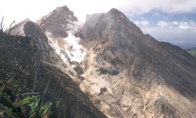 |
Figure 44. Photograph of the dome area at Soufriere Hills taken in late January 1999. This was used to calculate the dome volume and shows an exceptionally clear view of the gully running through the dome. Courtesy MVO; photograph by Richard Herd and Chloe Harford. |
Seismicity. Seismicity in December consisted chiefly of volcano-tectonic earthquakes and rockfall signals. Many of the latter were associated with small pyroclastic flows or venting. Small clusters of earthquakes were located under George's Hill to the NW of the dome, under Roaches Yard to the SE, and under Hermitage Estate to the NE.
Overall, January was quiet seismically. Pyroclastic-flow signals had low-frequency precursors. These events were associated with booming noises and were followed by periods of vigorous ash venting, suggesting the collapses were caused by violent degassing of the dome.
Ground deformation. The only area where significant deformation took place in December was on the E flank. The vectors for Long Ground showed eastward movement of these two sites amounting to 5 cm since lava stopped erupting. Most of this movement occurred during the last three months (a time of increased surface activity). The differential movement between Whites and Long Ground since June 1996 is more than 10 cm. The two sites are 733 m apart and the movement between them cannot be fit elastically. A ground inspection on 30 December revealed a possible fault between the two sites. The only surface expression is a linear break in the road and it is not currently known whether this is related to volcanic deformation or to surficial movements. The Tar River GPS pin has followed a similar movement to Long Ground throughout the eruption. The Perches site, until it was destroyed in July, followed a similar path. One possible interpretation is that a sector of the volcano including Long Ground, Perches, and Tar River is moving as a block along faults in a NE direction.
Eastward movement of Long Ground and Tar River continued in January but at a reduced rate. A local EDM network of five pins was set up on 27 January to learn whether the surface feature is a fault.
Environmental monitoring. The miniCOSPEC was used several times in December. The SO2 flux was elevated and on 22 December and reached a peak average flux of 1,700 metric tons per day (figure 45). Sulfur-dioxide flux decreased throughout January, but generally remained elevated. Concentrations were also measured at ground level by using diffusion tubes around the island.
 |
Figure 45. Average daily SO2 fluxes at Soufriere Hills measured by miniCOSPEC, December 1998-January 1999. The lines connecting measured points are guidelines only; the actual measured levels varied. The measurements made on 19 January showed a very low flux: observations suggested that at least part of the plume was at a very low altitude and may have been found partly below the elevation of the traversing helicopter. Data courtesy of MVO. |
Ash and rainwater collection continued throughout January. Ash samples from the small explosive events tended to very coarse, with lithic and crystal fragments up to 6 mm in size in the Richmond Hill-St. Georges area. In contrast, ash generated by dome-collapse pyroclastic flows was very fine-grained.
Volume measurements. A detailed photographic and theodolite survey was conducted from twelve sites around the volcano at the end of January. A photographic survey was also conducted from the helicopter with the GPS onboard. The information has been processed to produce a detailed dome map and volume measurement. The dome had a volume of 76.8 x 10⁶ m3 and its highest point was 977 m at the top of the White River Valley. The dome was split deeply by the collapse on 3 July 1998 and by subsequent events. The N part of the dome, which comprises three main buttresses above Gages, the N flank, and Tar River, contains two-thirds of the total dome volume. The scar cuts up to 100 m into the pre-1995 crater floor and has removed a minimum of 5.4 x 10⁶ m3 of old rock from this area.
Geological Summary. The complex, dominantly andesitic Soufrière Hills volcano occupies the southern half of the island of Montserrat. The summit area consists primarily of a series of lava domes emplaced along an ESE-trending zone. The volcano is flanked by Pleistocene complexes to the north and south. English's Crater, a 1-km-wide crater breached widely to the east by edifice collapse, was formed about 2000 years ago as a result of the youngest of several collapse events producing submarine debris-avalanche deposits. Block-and-ash flow and surge deposits associated with dome growth predominate in flank deposits, including those from an eruption that likely preceded the 1632 CE settlement of the island, allowing cultivation on recently devegetated land to near the summit. Non-eruptive seismic swarms occurred at 30-year intervals in the 20th century, but no historical eruptions were recorded until 1995. Long-term small-to-moderate ash eruptions beginning in that year were later accompanied by lava-dome growth and pyroclastic flows that forced evacuation of the southern half of the island and ultimately destroyed the capital city of Plymouth, causing major social and economic disruption.
Information Contacts: Montserrat Volcano Observatory (MVO), Mongo Hill, Montserrat, West Indies (URL: http://www.mvo.ms/).