Report on Unnamed (Tonga) — March 1999
Bulletin of the Global Volcanism Network, vol. 24, no. 3 (March 1999)
Managing Editor: Richard Wunderman.
Unnamed (Tonga) Eruption NW of Tongatapu builds temporary island in January
Please cite this report as:
Global Volcanism Program, 1999. Report on Unnamed (Tonga) (Wunderman, R., ed.). Bulletin of the Global Volcanism Network, 24:3. Smithsonian Institution. https://doi.org/10.5479/si.GVP.BGVN199903-243030
Unnamed
Tonga
20.852°S, 175.55°W; summit elev. -296 m
All times are local (unless otherwise noted)
This volcanic center in the Tonga Islands, 35 km NW of Tongatapu (figure 1) and S of Falcon Island, forms part of the Tofua Volcanic Arc (TVA). The following report was compiled from various sources, as well as a submission from Paul Taylor based in part on information obtained from Tongan colleagues.
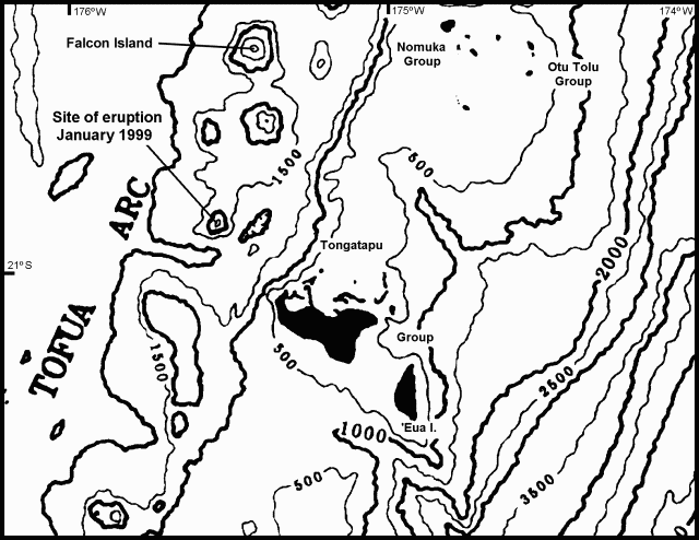 |
Figure 1. Location map of the southern part of the central region of the Tonga Platform and Tofua Volcanic Arc showing the site of the January 1999 volcanic activity in Tonga. Note the NNE-SSW trending trough-like feature that separates the volcanic arc and the Tonga Platform in this region, which may be a southerly extension of the Tofua Trough. Falcon Island is north of the January 1999 eruption site; the structure SSE of Falcon Island contains the islands of Hunga Ha'apai and Hunga Tonga, and was the site of submarine eruptions in 1912, 1937, and 1988. Bathymetric contours are at intervals of 500 m. Courtesy of Paul Taylor. |
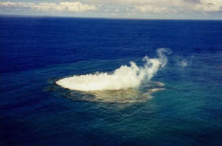
The Tonga Chronicle noted that the activity was first reported to Tonga Defense Services on 8 January by Carl Riechelmann, who had seen a plume coming from the site. On 12 January 1999 the Tonga Defence Services flew a photographic mission to record the reported appearance of a new island. Shortly after departing Tongatapu's Fua'amoto Airport in a Twin Beech equipped for surveillance operations, the crew sighted billowing white plumes from the volcano. The aircraft approached cautiously at 300 m altitude, made one circuit, then descended to 150 m for closer observation. The plane circled for almost an hour while a series of still photographs, as well as a video, were taken. During this time the crew noted that the island appeared to exhibit a pattern of rising, then receding. The island was estimated to be roughly 200-300 m long and 30-40 m wide. The crew also saw lava in a small vent that appeared to be located within a 100-m cone. The island was located at 20° 51.55'S, 175° 32.47'W (20.86°S, 175.54°W). Photographs and a report of their observations were posted on the website of Tonga Cable and Wireless.
Submarine activity continued on 14 January, with turbulent water present around a 40 x 300 m shoal, but no island was observed. Reports described a vent producing an ash-and-steam column and ejecting lava fragments, and floating pumice near the eruption site.
A precautionary Notice to Airmen (NOTAM) was issued to aviators on 14 January by the Nadi Aviation Control Center declaring an area within 5.5 km of the eruption site a danger area. Pilots were requested to report any signs of volcanic activity. Tongan officials also issued a warning to shipping transiting the area.
On 15 January a survey team, including two geologists from the Ministry of Land, Survey, and Natural Resources, inspected the island from the deck of the VOEA Savea, according to a report in the Tonga Chronicle. At that time the island had disappeared beneath the ocean surface, but the site was still emitting smoke and fumes. Because of possible danger, boats were warned to stay away.
Geological Summary. An unnamed submarine volcano is located along the Tofus volcanic arc 35 km NW of the Niu Aunofo lighthouse on Tongatapu Island. The first documented eruptions took place in 1911 and 1923; an ephemeral island was formed in 1999. A submarine eruption in January 2017 produced discolored water visible in satellite imagery.
Information Contacts: Paul W. Taylor, Australian Volcanological Investigations, PO Box 291, Pymble, NSW 2073, Australia; Kelepi Mafi, Ministry of Lands, Survey, and Natural Resources, P.O. Box 5, Nuku'Alofa, Kingdom of Tonga; Tonga Cable and Wireless, Private Bag 4, Nuku'alofa, Kingdom of Tonga (URL: http://www.candw.to/); Tonga Chronicle, PO Box 197, Nuku'alofa, Kingdom of Tonga; Tom Fox, International Civil Aviation Organization, 999 University Street, Montreal, Quebec H3C 5H7, Canada; Brad Scott, Wairakei Research Centre, Institute of Geological and Nuclear Sciences (IGNS) Limited, Private Bag 2000, Wairakei, New Zealand (URL: https://www.gns.cri.nz/).