Report on Tenorio (Costa Rica) — March 1999
Bulletin of the Global Volcanism Network, vol. 24, no. 3 (March 1999)
Managing Editor: Richard Wunderman.
Tenorio (Costa Rica) Tectonic earthquake swarm in late 1998
Please cite this report as:
Global Volcanism Program, 1999. Report on Tenorio (Costa Rica) (Wunderman, R., ed.). Bulletin of the Global Volcanism Network, 24:3. Smithsonian Institution. https://doi.org/10.5479/si.GVP.BGVN199903-345031
Tenorio
Costa Rica
10.673°N, 85.015°W; summit elev. 1916 m
All times are local (unless otherwise noted)
Tenorio volcano is located between Rincón de la Vieja (to the NW) and Arenal (to the SE). This region now has a new telemetric, digital seismic network consisting of six stations. Although not well instrumented for seismic measurements, Tenorio normally has very little seismic activity. In contrast to this historically moderate seismicity, an earthquake swarm with many tectonic events was recorded at both Tenorio and nearby Miravalles volcano during October and November 1997 (BGVN 22:10).
During October-November 1998 a total of 170 microearthquakes were recorded in the Tenorio area, 82 of which were located. Most events were recorded during 17-23 October, with up to 10 felt by people near the epicenter in Tierras Morenas (Barquero and Taylor, 1998). Magnitudes were 0.9-3.3 at depths of 0.5-10 km (most <2 km) and a maximum intensity of MM IV.
Within the Tenorio area are several fault systems oriented mainly NW-SE and NE-SW. There are also complex old volcanic caldera structures. The seismic swarms recorded in 1997 and 1998 denoted tectonic activity in these fault systems, considered neotectonic structures, and so they are not thought to be related to volcanic activity.
References. Barquero, R., and Taylor, W., 1998, Proyecto Geotérmico Tenorio: Los enjambres sísmicos periodo octubre-noviembre de 1997 y 1998: Informe preliminar. Inf. OSV 98.11 ICE, 15 p.
Further References. Boschini, I., 1998, Análisis preliminar del enjambre de sismos de la región de Miravalles-Tenorio de octubre y noviembre de 1997: Inf. OSV 98.08 ICE, 36 p.
ENEL, 1990: Estudios de reconocimiento y prefactibilidad geotérmica en la República de Costa Rica. Fase II. Estudio de prefactiblidad del area de Tenorio: Informe de Síntesis, 66 p.
ICE-ELC, 1983, informe geo-vulcanológico, Pyrotecto Geotérmico Miravalles: Informe interno ICE, 53 p.
Guillot, P.Y., Chiesa, S., and Alvarado, G., 1994, Chronostratigraphy of Upper Miocene-Quaternary volcanism in northern Costa Rica: Rev. Geol. Amér. Central, v. 17, p. 45-53.
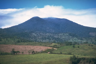
Geological Summary. The 225 km2 dominantly andesitic Tenorio volcanic massif anchors the SE end of the Guanacaste Range and consists of a cluster of densely forested NNW-SSE-trending volcanic cones. Overlapping lava flows from the principal peak, Tenorio, cover the NW-to-SW flanks and descend the NE flank. The NW-most of three craters on the central cone is sparsely vegetated and appears to be the most recently active. Volcán Montezuma to the north has two craters, the northern of which was the source of a lava flow to the NE. Additional pyroclastic cones are found to the NE and SW of the central complex, and the Bijagua lava domes were constructed on the N flank. A major debris avalanche covered about 100 km2 below the S flank. A legend exists of an eruption in 1816 CE, but the volcano was densely forested at the time of an 1864 visit by Seebach and no documented eruptions are known. Fumarolic activity is present on the NE flank.
Information Contacts: Rafael Barquero, Observatorio Sismológico y Vulcanológico Arenal-Miravalles (OSIVAM), Instituo Costaricense de Electricidad (ICE), Apdo. 10032-1000, San José, Costa Rica.