Report on Yasur (Vanuatu) — April 1999

Bulletin of the Global Volcanism Network, vol. 24, no. 4 (April 1999)
Managing Editor: Richard Wunderman.
Yasur (Vanuatu) Cyclical eruptive activity documented during 1994-98
Please cite this report as:
Global Volcanism Program, 1999. Report on Yasur (Vanuatu) (Wunderman, R., ed.). Bulletin of the Global Volcanism Network, 24:4. Smithsonian Institution. https://doi.org/10.5479/si.GVP.BGVN199904-257100
Yasur
Vanuatu
19.532°S, 169.447°E; summit elev. 361 m
All times are local (unless otherwise noted)
Five years of seismic monitoring at Yasur (figure 17) suggests cycles of several months duration. Long periods of vigorous Strombolian and associated seismic activity have been followed by shorter periods of lower activity. Specifically, as seen in the upper part of figure 17, more vigorous eruptions and seismic activity prevailed from January 1994 to February 1995; this was followed by a sustained period of lower intensity activity during April-August 1995. More vigorous Strombolian eruptions and seismicity returned during May 1996-June 1997; this was followed by a quieter period during July-December 1997 (middle part of figure 17). Next, intense eruptive and seismic activity again prevailed during January-May 1998 (bottom part of figure 17); limited explosive behavior occurred from June 1998 to May 1999. The latter interval included the explosions seen during 9-10 September 1998 (BGVN 23:09), events that in the broad overview of Yasur's behavior ranked as comparatively modest.
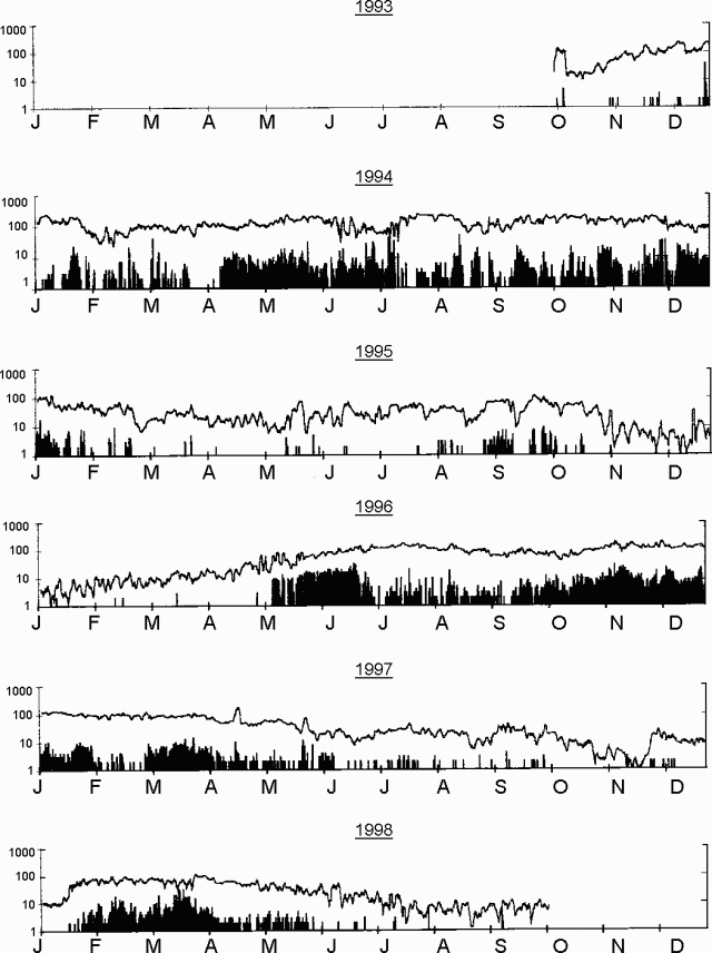 |
Figure 17. Daily seismicity recorded 2 km from Yasur during January 1994 through October 1998. The lines represent total counts for events with seismograph displacements greater than 12.5 µm; note that the lines are plotted on a logarithmic vertical scale. Data after October 1998 were not available. Courtesy of IRD. |
A large bomb ejected during January 1998 landed in a relatively flat spot more than 300 m from the crater's E rim (figure 18, bold star). Figure 19 shows a photo of the bomb and its impact crater taken after the bomb cooled. The bomb's size and the distance from the crater attests to the danger of approaching the vents and working on the volcano.
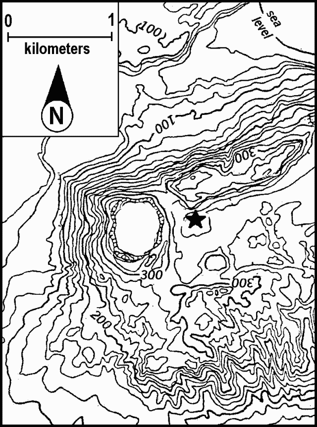 |
Figure 18. A topographic map of Yasur's crater and vicinity (N Tanna Island) showing the point where a large bomb struck (bold star to E of crater) in January-February 1998. Contours indicate elevations in meters (20 m contour interval). The sea lies on the map's upper right corner. Courtesy of Michel Lardy, IRD. |
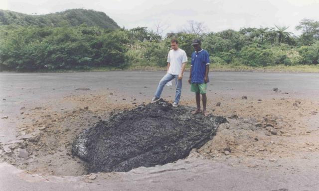 |
Figure 19. Bomb ejected from Yasur found ~ 300 m from the E rim. The photograph was taken in January 1998. Courtesy IRD. |
An artist's rendering (figure 20) depicts the crater configuration in March 1998; this morphology was established following the high-activity period of 1994. Only two crater-like vents remained, B and C ("A" was gone; BGVN 20:08, 21:08, 21:09, 22:08, and 22:11). Few if any subsequent changes occurred between March 1998 (when the sketch was made) and mid-May 1999; similarly, structural changes were also absent in this interval.
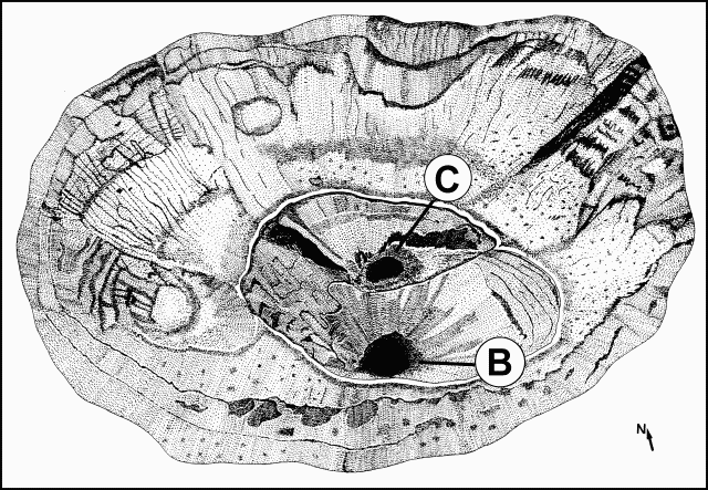 |
Figure 20. Yasur crater (Tanna Island) as it appeared in March 1998; the crater stretches ~ 700 m in the NE-SW direction by ~ 400 m in the NW-SE direction. Labels B and C correspond to named craters. The sketch was made from a photograph; courtesy of Alfréda Mabonlala and IRD. |
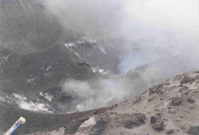 |
Figure 21. Yasur's two active intracrater vents, B (foreground) and C (farther back), as shot looking to the N in March 1998. The tube in the left foreground holds a filter for collecting samples for Polonium lab analysis. Courtesy of Michel Lardy, IRD. |
Geological Summary. Yasur has exhibited essentially continuous Strombolian and Vulcanian activity at least since Captain Cook observed ash eruptions in 1774. This style of activity may have continued for the past 800 years. Located at the SE tip of Tanna Island in Vanuatu, this pyroclastic cone has a nearly circular, 400-m-wide summit crater. The active cone is largely contained within the small Yenkahe caldera, and is the youngest of a group of Holocene volcanic centers constructed over the down-dropped NE flank of the Pleistocene Tukosmeru volcano. The Yenkahe horst is located within the Siwi ring fracture, a 4-km-wide open feature associated with eruption of the andesitic Siwi pyroclastic sequence. Active tectonism along the Yenkahe horst accompanying eruptions has raised Port Resolution harbor more than 20 m during the past century.
Information Contacts: Michel Lardy, Institut de recherche pour le développement (IRD), P.O. Box 76, Port Vila, Vanuatu; Jeannette Tabbagh, CRG-CNRS,58150 Garchy, France; Douglas Charley, Department of Geology, Mines and Water Resources, PMB 01, Port Vila, Vanuatu.