Report on Cosiguina (Nicaragua) — April 1999
Bulletin of the Global Volcanism Network, vol. 24, no. 4 (April 1999)
Managing Editor: Richard Wunderman.
Cosiguina (Nicaragua) Temperature and pH measurements of the fresh crater lake
Please cite this report as:
Global Volcanism Program, 1999. Report on Cosiguina (Nicaragua) (Wunderman, R., ed.). Bulletin of the Global Volcanism Network, 24:4. Smithsonian Institution. https://doi.org/10.5479/si.GVP.BGVN199904-344010
Cosiguina
Nicaragua
12.98°N, 87.57°W; summit elev. 872 m
All times are local (unless otherwise noted)
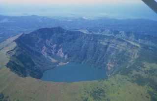
A team from the Université de Montréal, Open University, and INETER visited Cosigüina volcano on 25 February 1999. The summit crater contains a roughly circular lake with a dark green color. The lake has a maximum diameter of ~1.5 km and occupies about 90% of the crater bottom, the remaining area being covered with dense vegetation. The surface temperature of the lake measured from the NW shore with a thermocouple was ~27°C, slightly lower than the ambient air temperature (~31°C) measured at noon. The pH of the lake surface water measured directly with a glass electrode was slightly alkaline (pH ~7.5). Feeble, diffuse gas was bubbling at the surface of the lake along the NW shore. Temperature of the ground in these areas reached a maximum of ~80°C. There was no sign of recent hot spring or fumarolic activity in the crater. One spring located on the E flank of the volcano near the village of Potosi had a temperature of ~42°C, a flow rate of ~2 l/s and a total dissolved solids content 100 mg/kg. Apparently, it is the only permanent, visible hydrothermal manifestation near the volcano.
Geological Summary. Cosigüina (also spelled Cosegüina) is a low basaltic-to-andesitic composite volcano that is isolated from other eruptive centers in the Nicaraguan volcanic chain. The stratovolcano forms a large peninsula extending into the Gulf of Fonseca at the western tip of the country. It has a pronounced somma rim on the northern side; a young summit cone rises 300 m above the northern somma rim and buries the rim on other sides. The younger cone is truncated by a large elliptical prehistorical summit caldera, 2 x 2.4 km in diameter and 500 m deep, with a lake at its bottom. Lava flows predominate in the caldera walls, although lahar and pyroclastic-flow deposits surround the volcano. A brief but powerful explosive eruption in 1835 is Nicaragua's largest during historical time. Ash fell as far away as México, Costa Rica, and Jamaica, and pyroclastic flows reached the Gulf of Fonseca.
Information Contacts: Pierre Delmelle, Département de Géologie, Université de Montréal, Montréal, Québec H3C 3J7, Canada; Glyn Williams-Jones, Department of Earth Sciences, The Open University, Milton Keynes MK7 6AA, England, United Kingdom; José Garcia Alavarez, Martha Navarro, and Wilfried Strauch, INETER, Apartado Postal 2110, Managua, Nicaragua.