Report on Slamet (Indonesia) — May 1999
Bulletin of the Global Volcanism Network, vol. 24, no. 5 (May 1999)
Managing Editor: Richard Wunderman.
Slamet (Indonesia) Tremor and ash emission mark greatest unrest since last eruption in 1989
Please cite this report as:
Global Volcanism Program, 1999. Report on Slamet (Indonesia) (Wunderman, R., ed.). Bulletin of the Global Volcanism Network, 24:5. Smithsonian Institution. https://doi.org/10.5479/si.GVP.BGVN199905-263180
Slamet
Indonesia
7.242°S, 109.208°E; summit elev. 3428 m
All times are local (unless otherwise noted)
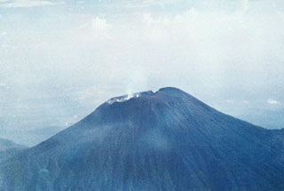
Mount Slamet has been predominantly quiet since its last eruption in 1989. During the week of 27 April-3 May, however, the volcano's status was raised to "Alert." That week and the next, "white ash emissions" reached 400 m and hot-spring temepratures ranged from 40 to 81°C. Tremors constituted the dominate seismic events. Slamet ejected black ash from its crater over 1-2 May, prompting concern. Government officials warned residents to stay away from the area following several outbursts within a 10-day period.
During 4-17 May seismicity was dominated by tremor with 4- to 30-mm amplitudes, and "thin-to-thick white ash plumes" reached 400 m height. During 18-24 May ash plumes only rose 25-100 m; tremor amplitudes declined to 0.5-20 mm. There was an increase in volcanic events, with B-type events increasing from 9 to 68 and A-type increasing from 10 to 26.
Geological Summary. Slamet is one of Java's most active volcanoes. It has a cluster of about three dozen cinder cones on its lower SE-NE flanks and a single cinder cone on the W flank. It is composed of two overlapping edifices, an older basaltic andesite to andesitic volcano on the west and a younger basaltic to basaltic andesite one on the east. Gunung Malang II cinder cone on the upper E flank on the younger edifice fed a lava flow that extends 6 km E. Four craters occur at the summit of Gunung Slamet, with activity migrating to the SW over time. Eruptions recorded since the 18th century have originated from a 150-m-deep, 450-m-wide, steep-walled crater at the western part of the summit and have consisted of explosive eruptions generally lasting a few days to a few weeks.
Information Contacts: Volcanological Survey of Indonesia (VSI), Jalan Diponegoro No. 57, Bandung 40122, Indonesia (URL: http://www.vsi.esdm.go.id/).