Report on Iwatesan (Japan) — May 1999
Bulletin of the Global Volcanism Network, vol. 24, no. 5 (May 1999)
Managing Editor: Richard Wunderman.
Iwatesan (Japan) A M 3.6 tectonic earthquake in September preceded ongoing seismic swarms
Please cite this report as:
Global Volcanism Program, 1999. Report on Iwatesan (Japan) (Wunderman, R., ed.). Bulletin of the Global Volcanism Network, 24:5. Smithsonian Institution. https://doi.org/10.5479/si.GVP.BGVN199905-283240
Iwatesan
Japan
39.853°N, 141.001°E; summit elev. 2038 m
All times are local (unless otherwise noted)
A large tectonic earthquake near Iwate on 3 September 1998 (BGVN 23:09) was followed by elevated rates of seismicity and ground deformation that declined in subsequent months (figure 3). In late 1998 volcanic tremor was recorded up to ten times per month and earthquakes around the Moho discontinuity occurred >10 times per month.
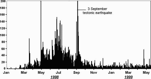 |
Figure 3. Daily numbers of earthquakes at Iwate (recorded at the Matsukawa station) during 1 January 1998-14 May 1999. Courtesy JMA. |
At 1909 on 22 May 1999, a M 3.6 earthquake occurred around the W edge of Nishi-Iwate. The earthquake was followed 8 minutes later by another of M 2.2. These volcanic earthquakes were the largest of a swarm centered at 3-6 km depth. No episodes of tremor were observed and no surface manifestations were detected by video monitoring or during a helicopter flight.
The National Coordination Committee for Prediction of Volcanic Eruption said that the largest earthquakes in the swarm occurred in the W region of the volcano, where shallow (5-10 km in depth) low-frequency volcanic earthquakes had been increasing (figure 4). They also observed that deep (~30 km in depth) low-frequency earthquakes had been occurring regularly with some minor increases and decreases in frequency. GPS observation showed relatively low but steady ground-deformation in the western region of the volcano. Gas measurement showed an increase in below-ground temperature and also indicated the gas chemistry had become more magmatic since September 1998. Their conclusion was that Iwate was showing a slight increase in activity.
 |
Figure 4. Hypocenters of earthquakes around Iwate during 1 April-13 May 1999. Courtesy JMA. |
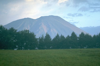
Geological Summary. Viewed from the east, Iwatesan volcano has a symmetrical profile that invites comparison with Fuji, but on the west an older cone is visible containing an oval-shaped, 1.8 x 3 km caldera. After the growth of Nishi-Iwate volcano beginning about 700,000 years ago, activity migrated eastward to form Higashi-Iwate volcano. Iwate has collapsed seven times during the past 230,000 years, most recently between 739 and 1615 CE. The dominantly basaltic summit cone of Higashi-Iwate volcano, Yakushidake, is truncated by a 500-m-wide crater. It rises well above and buries the eastern rim of the caldera, which is breached by a narrow gorge on the NW. A central cone containing a 500-m-wide crater partially filled by a lake is located in the center of the oval-shaped caldera. A young lava flow from Yakushidake descended into the caldera, and a fresh-looking lava flow from the 1732 eruption traveled down the NE flank.
Information Contacts: Hiroyuki Hamaguchi, Faculty of Science, Tohoku University, Sendai 980, Japan; Kazuo Sekine, Sendai District Meteorological Observatory, Japan Meteorological Agency, 1-3-15 Gorin, Miyagino-ku, Sendai 983, Japan; Volcano Research Center, Earthquake Research Institute (ERI), University of Tokyo, Yayoi 1-1-1, Bunkyo-ku, Tokyo 113, Japan (URL: http://www.eri.u-tokyo.ac.jp/VRC/index_E.html).