Report on Yellowstone (United States) — September 1999
Bulletin of the Global Volcanism Network, vol. 24, no. 9 (September 1999)
Managing Editor: Richard Wunderman.
Yellowstone (United States) Earthquake swarm during June along mapped faults
Please cite this report as:
Global Volcanism Program, 1999. Report on Yellowstone (United States) (Wunderman, R., ed.). Bulletin of the Global Volcanism Network, 24:9. Smithsonian Institution. https://doi.org/10.5479/si.GVP.BGVN199909-325010
Yellowstone
United States
44.43°N, 110.67°W; summit elev. 2805 m
All times are local (unless otherwise noted)
A series of earthquake swarms began along the NW edge of Yellowstone National Park on the evening of 13 June 1999. Between 13 and 22 June over 630 earthquakes were recorded in a region ~13 km NE of the town of West Yellowstone, Montana and ~5 km SE of Grayling Creek Junction, Montana. The largest of the earthquakes, M 3.5, occurred at 1038 on 16 June. No residents reported noticing the earthquakes. The activity was located along mapped faults that extend eastward from the S end of 1959 Hebgen Lake rupture (the 7.5 magnitude Hebgen Lake earthquake was the largest in the history of the Intermountain region). Earthquake swarms are common in Yellowstone, but this was the largest since June 1997. That swarm also occurred along the NW edge of the park, the area that historically records the most persistent swarms. The most extensive recorded earthquake swarm occurred ~10 km SE of the June activity over a period of several months in 1985 and 1986.
Seismicity in the Yellowstone region is recorded by 22 University of Utah Seismograph Stations and two Global Positioning System stations. The telemetered surveillance system provides coverage for both earthquakes and ground movement related to volcanic or earthquake activity. The project is conducted cooperatively with the U.S. Geological Survey Volcano Hazards Program and the National Park Service.
As discussed by Robert B. Smith on his web pages at the University of Utah, Yellowstone National Park is located on a hotspot within the North American Plate; its three calderas are the most recent in a string that extends to the SW across Idaho. Dubbed "The Restless Giant" for its geological instability, Yellowstone could one day have another major eruption like the one that formed its youngest caldera 600,000 years ago. Symptoms include numerous earthquakes (most too small to be felt), uplift and subsidence of the ground surface, and persistent hydrothermal activity. The current rates of seismicity, ground deformation, and hydrothermal activity at Yellowstone, although high by most geologic standards, are probably typical of long time periods between eruptions and therefore not a reason for immediate concern. Scientists from the U.S. Geological Survey and the University of Utah are studying the Yellowstone region to assess the potential hazards from future earthquakes and eruptions and to provide warning if the current level of unrest should intensify.
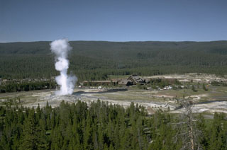
Geological Summary. The Yellowstone Plateau volcanic field developed through three volcanic cycles spanning two million years that included some of the world's largest known eruptions. Eruption of the over 2,450 km3 Huckleberry Ridge Tuff about 2.1 million years ago created the more than 75-km-long Island Park caldera. The second cycle concluded with the eruption of the Mesa Falls Tuff around 1.3 million years ago, forming the 16-km-wide Henrys Fork caldera at the western end of the first caldera. Activity subsequently shifted to the present Yellowstone Plateau and culminated 640,000 years ago with the eruption of the over 1,000 km3 Lava Creek Tuff and the formation of the present 45 x 85 km caldera. Resurgent doming subsequently occurred at both the NE and SW sides of the caldera and voluminous (1000 km3) intracaldera rhyolitic lava flows were erupted between 150,000 and 70,000 years ago. No magmatic eruptions have occurred since the late Pleistocene, but large hydrothermal events took place near Yellowstone Lake during the Holocene. Yellowstone is presently the site of one of the world's largest hydrothermal systems, including Earth's largest concentration of geysers.
Information Contacts: U.S. Geological Survey, Cascades Volcano Observatory, 5400 MacArthur Blvd., Vancouver, WA 98661 USA (URL: https://volcanoes.usgs.gov/observatories/cvo/); Michael Finley, Tom Deutch, and Anne Deutch, National Park Service, P.O. Box 168, Yellowstone, WY 82190 USA (URL: https://www.nps.gov/yell/); Robert B. Smith, Department of Geology and Geophysics, 135 S. 1460 East, Room 702, University of Utah, Salt Lake City, UT 84112 USA.