Report on Kilauea (United States) — September 1999

Bulletin of the Global Volcanism Network, vol. 24, no. 9 (September 1999)
Managing Editor: Richard Wunderman.
Kilauea (United States) Abrupt changes in tilt, tremor, and extrusive output due to an inferred intrusion
Please cite this report as:
Global Volcanism Program, 1999. Report on Kilauea (United States) (Wunderman, R., ed.). Bulletin of the Global Volcanism Network, 24:9. Smithsonian Institution. https://doi.org/10.5479/si.GVP.BGVN199909-332010
Kilauea
United States
19.421°N, 155.287°W; summit elev. 1222 m
All times are local (unless otherwise noted)
Early on the morning of 12 September monitoring instruments detected a swarm of small earthquakes and volcanic tremor on the east rift zone, and a sharp deflation (tilt) of the summit area and parts of the east rift zone. A pause in on-going eruptive activity also occurred. These effects were interpreted as due to a new intrusion of magma. Apparently, magma moved from both the summit area and from near Pu`u `O`o into the upper rift zone, forming a dike in the area between Pauahi Crater and Mauna Ulu.
Figure 142 shows the seismic record for part of 11-12 September. After tremor associated with the seismic swarm ceased, another pause in episode 55 of the Pu`u `O`o-Kupaianaha eruption began at 0131 on 12 September. This change was thought to be due to the above-mentioned intrusion.
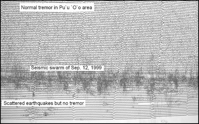 |
Figure 142. Part of the 11-12 September seismogram for station STC near Pu`u `O`o at Kīlauea. There is a time difference of 15 minutes between each horizontal line and 1 minute between each small tic. Volcanic tremor was normal before the seismic swarm of 12 September but absent afterward. This absence of tremor was due to a pause in eruptive activity during the time of the swarm. Courtesy of the Hawaiian Volcano Observatory. |
The onset of seismic activity and tilting on 12 September was abrupt and simultaneous to within the one-minute resolution of the tilt data. Strong tilt commenced early on 12 September, as indicated by the vertical line on figure 143, where tilt for a station was toward the caldera. A swarm of small earthquakes along the upper rift zone accompanied the ground deformation. The downward tilt (figure 143) suggested that magma was moving away from and out of the summit reservoir. Data from two other tiltmeters on the E rift zone (E of Pauahi Crater and just uprift from Pu`u `O`o) indicated that the magma was moving into the rift zone. The reversal of summit tilt about 4-6 hours later suggests that when the intrusion stopped, magma once again moved into the summit reservoir. An inspection of the ground above the intrusion on 12 September did not reveal new ground cracks, which indicated that the intrusion remained 1-2 km below the surface. On the other hand, leveling across the zone of intrusion on 14 September showed elevation changes indicative of a dike, but its size and depth remained to be calculated. It was estimated that 3-5 million cubic meters intruded into the rift zone.
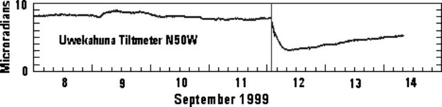 |
Figure 143. Kīlauea tiltmeter record for early September 1999 at Uwekahuna (tilt along an azimuth of N50W). Courtesy of Hawaiian Volcano Observatory. |
About eight hours after the start of the intrusion, the active lava bench on the S coast of Kīlauea began collapsing into the sea. Several small collapses were observed by scientists on 12 September. The lava bench began to collapse during 0800-0915 on 12 September and this process continued for most of the day (figure 144). By the evening of 13 September, about 2 x 10⁴ m2 of the S coast had been removed. The discharge of lava into the sea stopped completely in the afternoon of 13 September.
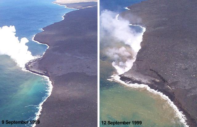 |
Figure 144. W-looking view of the lava bench on the S coast of Kīlauea as it appeared on 9 September (left) and at about noon on 12 September 1999 (right). Photo courtesy of J. Kauahikaua. |
Background. Kīlauea is one of five coalescing volcanoes that comprise the island of Hawaii. Historically its eruptions have originated primarily from the summit caldera or along one of the lengthy E and SW rift zones that extend from the caldera to the sea. The latest Kīlauea eruption began in January 1983 along the east rift zone. The eruption's early phases, or episodes, occurred along a portion of the rift zone that extends from Napau Crater on the uprift (toward the summit) end to ~8 km E on the downrift end (toward the sea). Mike Garcia has compiled a tabular summary of the episodes, now available on the web.
Activity eventually centered on the area and crater that were later named Pu`u `O`o. Between July 1986 and January 1992, the Kupaianaha lava lake was active ~3 km NE (downrift) of Pu`u `O`o. It was during this period that the town of Kalapana and most of the 181 homes lost were destroyed. In December 1991, one month before the shutdown of Kupaianaha, eruptive activity returned to Pu`u `O`o. More than 1 km3 of lava was erupted from January 1983 through January 1997.
Geological Summary. Kilauea overlaps the E flank of the massive Mauna Loa shield volcano in the island of Hawaii. Eruptions are prominent in Polynesian legends; written documentation since 1820 records frequent summit and flank lava flow eruptions interspersed with periods of long-term lava lake activity at Halemaumau crater in the summit caldera until 1924. The 3 x 5 km caldera was formed in several stages about 1,500 years ago and during the 18th century; eruptions have also originated from the lengthy East and Southwest rift zones, which extend to the ocean in both directions. About 90% of the surface of the basaltic shield volcano is formed of lava flows less than about 1,100 years old; 70% of the surface is younger than 600 years. The long-term eruption from the East rift zone between 1983 and 2018 produced lava flows covering more than 100 km2, destroyed hundreds of houses, and added new coastline.
Information Contacts: Hawaiian Volcano Observatory (HVO), U.S. Geological Survey, PO Box 51, Hawaii Volcanoes National Park, HI 96718, USA (URL: https://volcanoes.usgs.gov/observatories/hvo/); Mike Garcia, Hawaii Center for Volcanology, University of Hawaii, Dept. of Geology & Geophysics, 2525 Correa Rd., Honolulu, HI 96822 USA (URL: http://www.soest.hawaii.edu/GG/HCV/puuoo-episodes.html)