Report on Katla (Iceland) — September 1999
Bulletin of the Global Volcanism Network, vol. 24, no. 9 (September 1999)
Managing Editor: Richard Wunderman.
Katla (Iceland) Tremor in mid-July followed by a jökulhlaup and ice cauldron formation
Please cite this report as:
Global Volcanism Program, 1999. Report on Katla (Iceland) (Wunderman, R., ed.). Bulletin of the Global Volcanism Network, 24:9. Smithsonian Institution. https://doi.org/10.5479/si.GVP.BGVN199909-372030
Katla
Iceland
63.633°N, 19.083°W; summit elev. 1490 m
All times are local (unless otherwise noted)
In the early morning of 18 July, a small jökulhlaup (sudden glacier-outburst flood) lasting less than 24 hours, occurred in "Jökulsá á Sólheimasandi," one of the rivers draining from the Mýrdalsjökull icecap (figure 2) towards the S. Inspection of the icecap revealed that a new ice cauldron, ~2 km wide, and 50 m deep, had formed just above the origin of the Sólheimajökull outlet glacier. The jökulhlaup was preceded on 17 July by a 20-minute-long burst of modest volcanic tremor (reported by P. Einarsson). Intrusion of magma at a low level within the subglacial Katla volcano or even a small subglacial eruption may have occurred, possibly associated with pulse of CO2 which could have caused boiling in geothermal areas under the icecap.
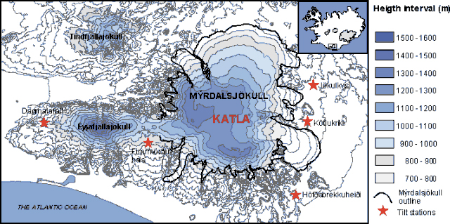 |
Figure 2. Topographic map of the Mýrdalsjökull icecap over Katla volcano showing tilt stations. Courtesy of the Nordisk Vulkvanologisk Institut. |
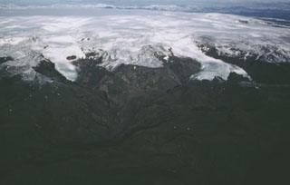
From 18 July until mid-August, ten new ice cauldrons formed along the W, S, and E borders of the Mýrdalsjökull caldera (figure 3), signifying increased geothermal activity along a large part of the caldera rim. Changes on the icecap surface have been reported for some of the earlier eruptions of Katla, and the current activity could be a possible long-term precursor to a new eruption. A flight over the area on 9 September by Reynir Ragnarsson at Vík, revealed that the ice cauldrons did not develop much after mid-August.
 |
Figure 3. One of the new ice cauldrons on Mýrdalsjökull, July-August 1999. Photo by Freysteinn Sigmundsson. |
Geological Summary. Katla volcano, located near the southern end of Iceland's eastern volcanic zone, is hidden beneath the Myrdalsjökull icecap. The subglacial basaltic-to-rhyolitic volcano is one of Iceland's most active and is a frequent producer of damaging jökulhlaups, or glacier-outburst floods. A large 10 x 14 km subglacial caldera with a long axis in a NW-SE direction is up to 750 m deep. Its high point reaches 1380 m, and three major outlet glaciers have breached its rim. Although most recorded eruptions have taken place from fissures inside the caldera, the Eldgjá fissure system, which extends about 60 km to the NE from the current ice margin towards Grímsvötn volcano, has been the source of major Holocene eruptions. An eruption from the Eldgjá fissure system about 934 CE produced a voluminous lava flow of about 18 km3, one of the world's largest known Holocene lava flows. Katla has been the source of frequent subglacial basaltic explosive eruptions that have been among the largest tephra-producers in Iceland during historical time and has also produced numerous dacitic explosive eruptions during the Holocene.
Information Contacts: Rósa Ólafsdóttir, Guðrún Sverrisdóttir, Freysteinn Sigmundsson, Erik Sturkell, and Níels Óskarsson, Nordisk Vulkvanologisk Institut, Grenásvegur 50, 108 Reyjavík, Iceland (URL: http://nordvulk.hi.is); Helgi Björnsson, Páll Einarsson, and Magnús Tumi Guðmundsson, Science Institute, University of Iceland, Dunhaga 3, 107 Reykjavík, Iceland (URL: http://www.raunvis.hi.is/); Ármann Höskuldsson, South Iceland Institute of Natural History, Strandvegur 50, 900 Vestmannaeyjar, Iceland (URL: https://www.nattsud.is/).