Report on Additional Reports (Unknown) — November 1999

Bulletin of the Global Volcanism Network, vol. 24, no. 11 (November 1999)
Managing Editor: Richard Wunderman.
Additional Reports (Unknown) Japan: Hydro-acoustic signals of a possible eruption detected
Please cite this report as:
Global Volcanism Program, 1999. Report on Additional Reports (Unknown) (Wunderman, R., ed.). Bulletin of the Global Volcanism Network, 24:11. Smithsonian Institution. https://doi.org/10.5479/si.GVP.BGVN199911-600500
Additional Reports
Unknown
Lat Unknown, Unknown; summit elev. m
All times are local (unless otherwise noted)
Robert Dziak at the NOAA/Pacific Marine Environmental Laboratory in Newport, Oregon reported that the large-aperture hydrophone array deployed throughout the north Pacific Ocean basin has been detecting extremely loud, tremor-like signals since May 1998. The best preliminary estimates of the signal sources lie ~1,000 km S of Honshu Island, Japan along the Volcano Island chain (astride the Bonin trench, figure 1).
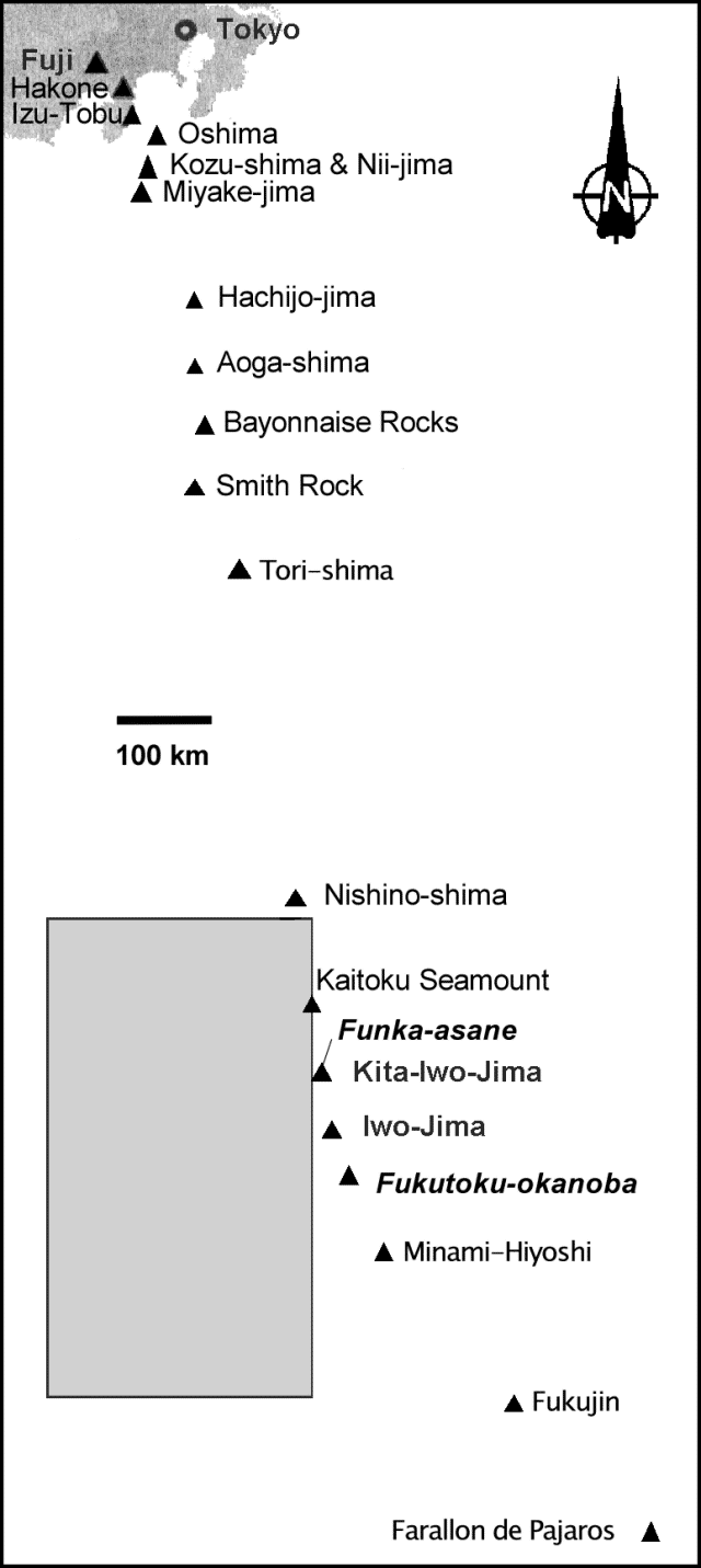 |
Figure 1. A sketch map of part of the island of Honshu, and some of the historically active volcanoes of the Izu, Marianas, and Bonin arcs. Data from the NOAA large-aperture hydrophone array indicates a submarine volcano has been erupting in the area within the box shown. Two possible candidate sources for the eruption discussed in the text are Fukutoku-okanoba and Kita-Iwo-jima (Funka-asane). Courtesy of Robert Dziak and Yasuo Otani. |
Dziak believes these tremors to be volcanic in origin. The signals are characterized by a high amplitude fundamental around 10 Hz and the next three harmonics (20, 30, and 40 Hz). Typically signals appear as discrete packets lasting 4-5 minutes, with a brief ~30 second quiescence period, followed by the beginning of the next signal packet. For the duration of each signal packet, the spectral peaks typically increase monotonically by 5-10 Hz while maintaining their harmonic spacing. Similar distinctive characteristics have been previously identified in volcanic tremor records from both seismic and airborne acoustic measurements at Arenal Volcano in Costa Rica (Garces et al., 1998) and at Pavlof Volcano, Alaska (Garces and Hansen, 1998).
Unfortunately, the source of these signals is outside the optimum coverage area for the NOAA array, so the estimated locations are not accurate; the best preliminary estimates place the signal source in a box at 22-27°N and 138-141°E that lies W of the Bonin arc (figure 1).
The tremor has been occurring intermittently since May 1998, and was still being recorded as of late December 1999. During this period, intense tremor activity was recorded on 30 different days. The signals have for the most part been occurring continuously (with quiet times ranging from several days to several weeks) since first detected. Specific periods of peak amplitude and duration in 1998 and 1999 are presented in table 1. Signals measured on 10-12 December 1999 were the loudest yet detected.
Table 1. Dates of the strongest hydro-acoustic signals registered on the NOAA large-aperture hydrophone array compared to observation dates of discolored seawater over Fukutoku-okanoba and the Funka-asane vent of Kita-Iwo-jima. Hydro-acoustic data courtesy of R. Dziak; seawater observations courtesy of Yasuo Otani, Japan Maritime Safety Agency and Japan Meteorological Agency.
| Periods of peak tremors from hydro-acoustic data | Discolored Seawater at Fukutoku-okanoba | Discolored Seawater at Kita-Iwo-jima (Funka-asane) |
| 16-18 Aug 1998 | -- | -- |
| 31 Aug 1998 | -- | -- |
| -- | 16 Oct 1998 | -- |
| -- | 28 Oct 1998 | -- |
| -- | 14 Dec 1998 | -- |
| -- | 16 Dec 1998 | -- |
| -- | 12-13 Jan 1999 | -- |
| 22 Apr 1999 | -- | -- |
| 20-27 Aug 1999 | -- | -- |
| -- | -- | 07 Sep 1999 |
| -- | 08 Sep 1999 | -- |
| 10-11 Oct 1999 | -- | -- |
| -- | 22 Nov 1999 | -- |
| -- | 10-12 Dec 1999 | -- |
Yasuo Otani of the Hydrographic Department of Japan has provided subsequent information (courtesy of Yukio Hayakawa) regarding periods of discolored sea water seen over Fukutoku-okanoba (24.3°N, 141.5°E). The latter is a known volcanic area located S of Iwo-Jima (24.75°N, 141.33°E) on the fringes of the area delineated above by Dziak. These dates are also presented in the second column of table 1; however, there does not appear to be an obvious correlation between the two data sets. On the other hand, what is not yet known is the density of visual observations, in effect, the number of observations of these sites when surface discolorations were absent. Without such details, trying to correlate the two data sets could be biased by sampling density.
Japan Meteorological Agency reports provided one other case of sea surface discoloration, at Funka-asane, but this lone observation also failed to show any temporal correlation and has the same limitations of sampling bias mentioned above. Funka-asane, a submarine vent ~2 km NW of Kita-Iwo-jima (25.43°N, 141.23°E), is just E of the preliminary box delineated by the acoustical data.
Olivier Hyvernaud at the Geophysical Laboratory in Tahiti had found no evidence of volcanic T-waves from the region in question through the end of 1999.
The area of the preliminary box is large, and could include many other volcanic centers. Given all of the uncertainty, anyone having possibly related data or comments is urged to contact Robert Dziak or the Smithsonian's Global Volcanism Network.
References. Garces, M.A., Hagerty, M.T., Schwartz, S.Y., 1998, Magma acoustics and time-varying melt properties at Arenal Volcano, Costa Rica: Geophysical Research Letters, v. 25, no. 13, p. 2293-6.
Garces, M.A., Hansen, R.A., 1998, Wave form analysis of seismoacoustic signals radiated during the fall 1996 eruption of Pavlof volcano, Alaska: Geophysical Research Letters, v. 25, no.7, p. 1051-4.
Geological Summary. Reports of floating pumice from an unknown source, hydroacoustic signals, or possible eruption plumes seen in satellite imagery.
Information Contacts: Robert P. Dziak, Oregon State University/NOAA, Hatfield Marine Science Center, 2115 SE OSU Drive, Newport, OR 97365 USA (URL: http://newport.pmel.noaa.gov/); Yasuo Otani, Coastal Surveys and Cartography Division, Hydrographic Department, Maritime Safety Agency, 3-1 Tsukiji, 5-Chome, Chuo-ku, Tokyo 104-0045, Japan; Olivier Hyvernaud, Laboratoire de Géophysique, BP 640 Pamatai, Tahiti, French Polynesia.