Report on Pacaya (Guatemala) — December 1999

Bulletin of the Global Volcanism Network, vol. 24, no. 12 (December 1999)
Managing Editor: Richard Wunderman.
Pacaya (Guatemala) Mid-January eruption spawns lava flow, 8-km-high plume, and evacuations
Please cite this report as:
Global Volcanism Program, 1999. Report on Pacaya (Guatemala) (Wunderman, R., ed.). Bulletin of the Global Volcanism Network, 24:12. Smithsonian Institution. https://doi.org/10.5479/si.GVP.BGVN199912-342110
Pacaya
Guatemala
14.382°N, 90.601°W; summit elev. 2569 m
All times are local (unless otherwise noted)
An INSIVUMEH report noted that Pacaya, which erupts frequently, had been relatively quiet through at least 1 September 1999. At that time its behavior was fumarolic only and tremor registered sporadically.
The rest of this report covers the interval from late December to 16 January. Anomalously large explosions took place during the days preceding 23 December, when Strombolian eruptions sent material 300-500 m high. The explosions originated in a narrow depression 50-75 m long on the upper SW flank, facing the city of Patrocinio. The activity was observed from points on the S coast. Shallow explosions created earthquakes in and around the volcano.
Atmospheric conditions remained relatively stable; a clear, calm wind blew from the N at ~35 km/hour. On 29 December weak explosions deposited rocks and fine ash over the edifice, and a constant fumarole emitted white and blue colored gases. The explosions that day created a plume 25 m high. A lava flow extended 75 m from the crater rim toward the SW, in the direction of Patrocinio. Tremor and explosions also occurred.
In January 2000, Pacaya remained restless. Otto Garcia reported that on 14 January a period of Strombolian activity began with lava flows and small explosions. Then, on 16 January, a comparatively violent explosion took place. Photographs taken from the NW (figures 25-28) showed high tephra ejections, a dark plume, and lava flows. According to NOAA reports received by Garcia, the tephra-bearing plume reached ~8-km altitude after the eruption climaxed around 2245. Winds spread tephra S and SE to the provinces of Escuintala, Siquninala, and Santa Lucia Cotz, and as far as 50 km S of the volcano. Lava fountains that rose 500-750 m above the cone were visible from Guatemala City, ~35 km N; the vigorous outburst lasted ~4 hours. In nearby villages 1,500 residents were evacuated.
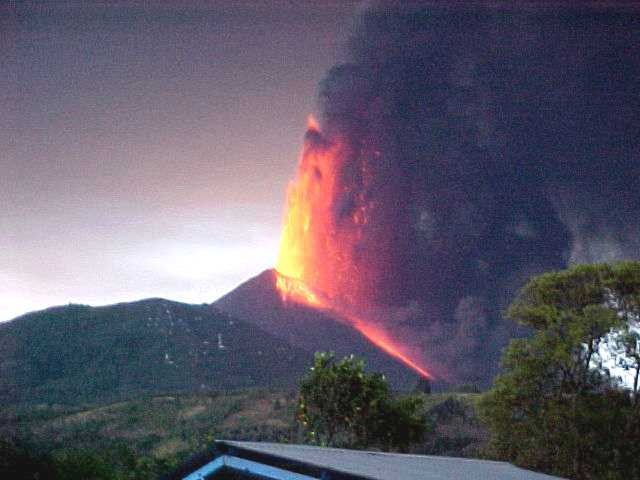 |
Figure 25. A powerful incandescent lava fountain rises above the summit of MacKenney cone at Pacaya on 16 January 2000. This view from the NW shows the forested flank vent Cerro Chino to the left. A dense ash column rises and is blown SW. A more vigorous phase of the eruption apparently occurred later, after dark. Courtesy of Manolo Barillas (CONRED). |
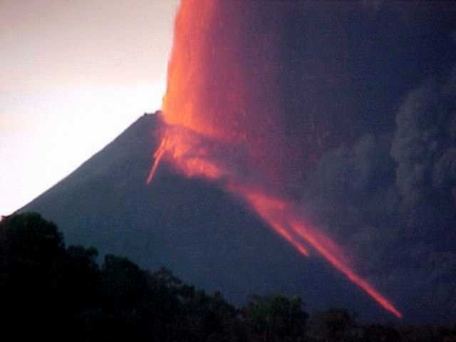 |
Figure 26. A daytime scene of the 16-17 January Pacaya eruption. The view is from the NW. Courtesy of Manolo Barillas (CONRED). |
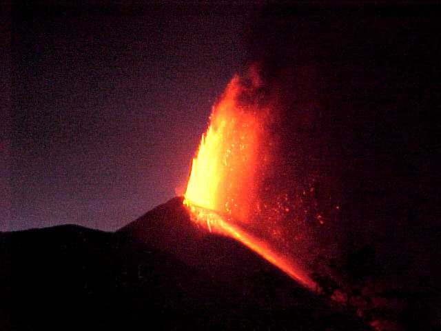 |
Figure 27. Pacaya's fountaining seen on the night of 16-17 January 2000. The view is from the NW. Courtesy of Manolo Barillas (CONRED). |
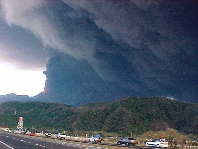 |
Figure 28. Dense, billowing ash clouds from Pacaya on 16 January 2000. Cars along the road between the towns of Amatitlán and Esquintla are in the foreground. Courtesy of Manolo Barillas (CONRED). |
The eruption was photogenic and appeared in numerous media reports. A CNN news report stated that by 17 January Eddie Sanchez of INSIVUMEH estimated that the lava flow had advanced 900 m down the mountain.
Tourist's photos and impressions. On the afternoon of 16 January guided tourist groups were visiting the volcano; some had ascended to an overlook when unusually energetic explosions occurred. One tourist, Gene Weast, wrote of his experience during the explosion in a brief letter that appeared on a website along with documenting photographs, including figure 29.
During the hike up the volcano, the guide cautioned the group to keep their distance from fresh lava, since such material had become larger and hotter in the last few days. Every 10 seconds an explosion from the summit sent rocks and lava 40-100 m high. As the sun began to set the explosions suddenly became louder, and chunks of lava (volcanic bombs) were thrown 0.5-1 km into the sky. Soon after the large explosions commenced, these bombs began to fall on the sides of the mountain. All of the guides and tourists ran back down the volcano and managed to escape the explosions safely.
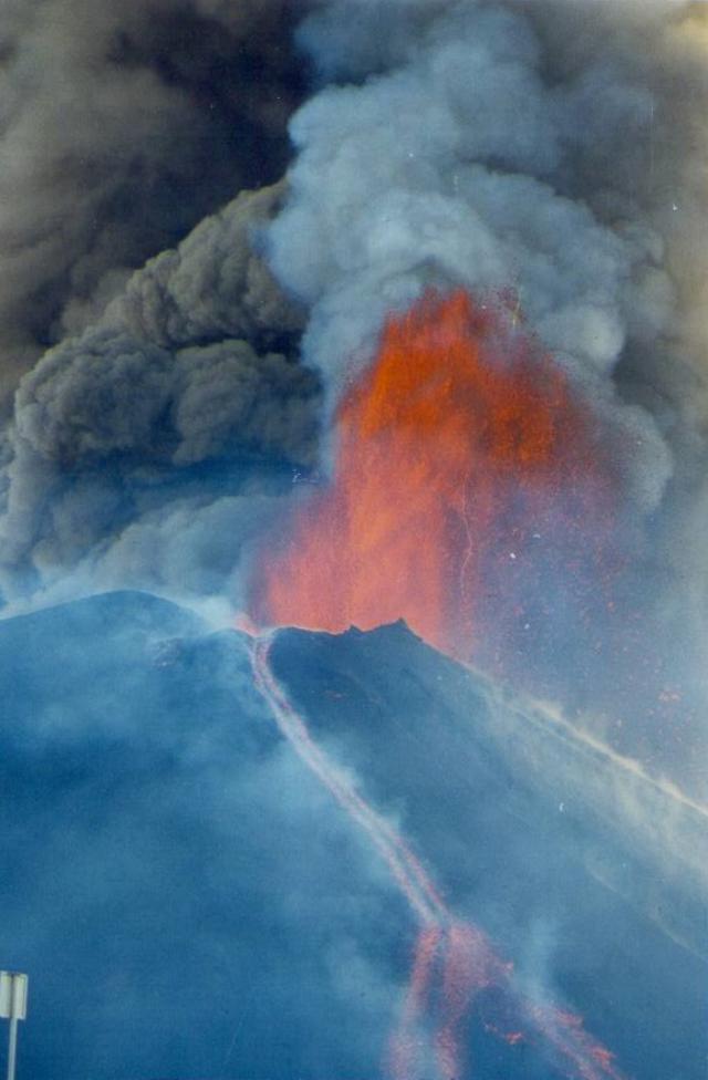 |
Figure 29. A photo of the violent 16 January 2000 explosion at Pacaya taken in the late afternoon with an 80 mm lens as the photographer stood on the rim of La Meseta, ~500 m from the summit vent. A Strombolian explosion ejected a spray of incandescent lava hundreds of meters into the air; the stream was framed by billows of dark, gray plumes that continued to rise above it. Some erupted material escaped through a notch in the MacKenney cone and formed a small lava flow that bifurcated in the lower part of the photograph. This flow headed toward the moat between the MacKenney cone and La Meseta rim. Courtesy of Gene Weast. |
Geological Summary. Eruptions from Pacaya are frequently visible from Guatemala City, the nation's capital. This complex basaltic volcano was constructed just outside the southern topographic rim of the 14 x 16 km Pleistocene Amatitlán caldera. A cluster of dacitic lava domes occupies the southern caldera floor. The post-caldera Pacaya massif includes the older Pacaya Viejo and Cerro Grande stratovolcanoes and the currently active Mackenney stratovolcano. Collapse of Pacaya Viejo between 600 and 1,500 years ago produced a debris-avalanche deposit that extends 25 km onto the Pacific coastal plain and left an arcuate scarp inside which the modern Pacaya volcano (Mackenney cone) grew. The NW-flank Cerro Chino crater was last active in the 19th century. During the past several decades, activity has consisted of frequent Strombolian eruptions with intermittent lava flow extrusion that has partially filled in the caldera moat and covered the flanks of Mackenney cone, punctuated by occasional larger explosive eruptions that partially destroy the summit.
Information Contacts: Eddie Sanchez and Otoniel Matias, Instituto Nacional de Sismología, Vulcanología, Meteorología e Hydrología (INSIVUMEH), Ministerio de Communicaciones, Transporte y Obras Publicas, 7A Avenida 14-57, Zona 13, Guatemala City, Guatemala; Otto García, 7a Avenida 14-44 zona 9, Edificio La Galeria, Oficina 11, 2do. Nivel, Guatemala, Guatemala; Manolo Barillas, Coordinadora Nacional para la Reducción de Desastres (CONRED), Avenida Hincapie 21-72 zona 13, Guatemala City, Guatemala; Gene Weast, 1061 SW Western Blvd., Corvallis, OR 97333 USA; Cable News Network (CNN) (URL: http://www.cnn.com/).