Report on Santa Ana (El Salvador) — December 1999
Bulletin of the Global Volcanism Network, vol. 24, no. 12 (December 1999)
Managing Editor: Richard Wunderman.
Santa Ana (El Salvador) Scientists visit the summit crater and sample the acid lake
Please cite this report as:
Global Volcanism Program, 1999. Report on Santa Ana (El Salvador) (Wunderman, R., ed.). Bulletin of the Global Volcanism Network, 24:12. Smithsonian Institution. https://doi.org/10.5479/si.GVP.BGVN199912-343020
Santa Ana
El Salvador
13.853°N, 89.63°W; summit elev. 2381 m
All times are local (unless otherwise noted)
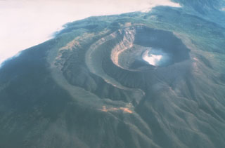
The acid lake within the summit crater of Santa Ana was extensively sampled by a scientific team using a small boat on 28-29 January 2000. The ambient lake temperature was ~18.9°C with 1.01 pH. A fumarole field on the crater wall adjacent to the lake had a maximum temperature of 523°C. A hot spring vent near the fumarole field feeds warm water (80°C) into the lake. This new lake sampling allows comparisons with data taken in 1992-93.
Santa Ana, El Salvador's highest volcano, is a large stratovolcano immediately W of Coatepeque Caldera. The broad volcano summit is cut by several crescent craters. A series of parasitic vents and cones have formed along a fissure system that extends from near the town of Chalchuapa N of the volcano to the San Marcelino cinder cone on the SE flank.
Geological Summary. Santa Ana (also known as Ilamatepec), is a massive, dominantly andesitic-to-trachyandesitic stratovolcano in El Salvador immediately W of Coatepeque Caldera. Collapse during the late Pleistocene produced a voluminous debris avalanche that swept into the Pacific Ocean, forming the Acajutla Peninsula. Reconstruction of the volcano subsequently filled most of the collapse scarp. The broad summit is cut by several crescentic craters, and a series of vents and cones have formed along a 20-km-long fissure system that extends from near the town of Chalchuapa NNW of the volcano to the San Marcelino and Cerro la Olla cinder cones on the SE flank. Small to moderate explosive eruptions from both summit and flank vents have been documented since the 16th century. The San Marcelino cinder cone on the SE flank produced a lava flow in 1722 that traveled 13 km E.
Information Contacts: Demetrio Escobar and Marisa Orantes, Centro de Investigaciones Geotecnicas, Calle Antigua La Chacra, Costado Oriente de Talleres "El Coro", PP 109 San Salvador, El Salvador; Alain Bernard, BRUGEL, Université Libre de Bruxelles 160/02 50, Ave. Roosevelt, 1050 Brussels, Belgium; Bill Rose, Colleen Riley, and Keith MacPhail, Department of Geological Engineering and Sciences, Michigan Technological University, Houghton, MI 49931, USA; Uwe Grunewald, Insitut fuer Geowissenschaften, Burgweg 11, 07749 Jena, Germany.

