Report on Pacaya (Guatemala) — January 2000

Bulletin of the Global Volcanism Network, vol. 25, no. 1 (January 2000)
Managing Editor: Richard Wunderman.
Pacaya (Guatemala) Map of new lava flows, satellite data, and perspective on the 16 January eruption
Please cite this report as:
Global Volcanism Program, 2000. Report on Pacaya (Guatemala) (Wunderman, R., ed.). Bulletin of the Global Volcanism Network, 25:1. Smithsonian Institution. https://doi.org/10.5479/si.GVP.BGVN200001-342110
Pacaya
Guatemala
14.382°N, 90.601°W; summit elev. 2569 m
All times are local (unless otherwise noted)
A vigorous new phase of explosive and effusive activity began at Pacaya in late 1999 (BGVN 24:12). The eruption began with Strombolian activity on 23 December 1999 and, by 16 January 2000, built a ~50-m-high cinder cone within the summit crater. On 4 January the lava had started to flow beyond the summit crater and, by 10 January, the lava extended 1 km down the SW flank. Subsequently, the summit crater fed a second lava flow that descended the 30-40° slopes along the N flank of Pacaya's central cone (figure 30). At the base of the cone, the lava channel bifurcated and the outer crater wall deflected the flows NW. Along its medial section, the southernmost channel was 5-7 m deep and 7-10 m wide. By 2130 on 14 January this portion of the flow had formed a tube. After exiting the channel and tube system, the lava formed a pond in the basin between the base of the cone and outer crater wall building a 200-m wide compound aa lava field ~1 km long. This field overlaid most of the lava field formed by the September 1998 eruption.
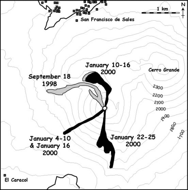 |
Figure 30. Sketch map of Pacaya showing flow fields active during September 1998 and January 2000. Courtesy of Otoniel Matías, Andy Harris, Bill Rose, Luke Flynn, and James Vallance. |
At 1615 on 16 January the eruption increased in intensity and changed from Strombolian to fountaining. These fountains fed ash plumes, which were observed on GOES images, and the cinder cone built earlier was destroyed during the first 5 minutes of the high intensity activity. Fountaining initially reached heights of 800 m but diminished to 300 m by 1830. Fallout from the fountains fed near-constant nuées ardentes and a lava flow that extended 600-700 m to the SW (figure 30). Within the summit crater lava fountaining appeared from about four vents, or possibly a fissure, with the highest and most vigorous fountains issuing from the southernmost sources. Fountains from these southernmost sources projected obliquely to the S. Strombolian activity returned around 2030.
The 16 January episode was one of the most spectacular at Pacaya in all of its current 35-year-long history of eruption. While the population of Guatemala City watched the fountaining, the fall of over 30 cm of tephra in the area S of the vent forced over 1,000 people to leave that area and closed the Aurora Airport that evening.
Activity in the morning of 19 January was characterized by low-level degassing but at 1325 an ash plume rose ~5 km above summit level. Ballistic block fall occurred during the first minute and a maximum temperatures of 97°C was measured at the base of the column a few minutes later. The plume spread mainly to the S, but wind shear caused spreading of the plume to the N and W. The intensity of ash emission began to wane and by 1415 the plume height had declined to 200-300 m and the ash plume temperature decreased to 24-35°C. Persistent ash emission continued from at least two sources within the summit crater throughout the afternoon with frequent larger pulses causing the plume to increase in height and temperature. Persistent ash emission continued to heights of ~50 m, with occasional puffs pushing the plume to ~100 m, causing higher temperatures and ash drifting 3-6 km to the S. Seismic records show that the high intensity portion of this eruption lasted 8 minutes followed by a 30-minute-long hiatus and then 7 to 8 pulses each lasting between 45 seconds and 4 minutes.
Seismic records indicated a renewal of activity in the late afternoon of 22 January. GOES hot spot monitoring tool (http://hotspot.higp.hawaii.edu/) indicated hot-spot activity beginning between 1725 and 1745 and relating to intracrater activity. A Landsat-7 Enhanced Thematic Mapper (ETM+) scene acquired at ~1030 on 23 January shows an intense thermal anomaly within the summit crater, a point source 180-240 m in diameter. The absence of an elongated anomaly extending from this source indicates that flow activity had not begun at that time.
By 24 January, Strombolian eruptions fed a persistent, diffuse plume of fine ash that rose ~1.5 km above the summit. Later observations on the same day showed vigorous, near-continuous Strombolian activity with explosions occurring at a rate of 19-28 events per minute and throwing incandescent bombs as large as 1-2 m in diameter and occasional ribbon spatter to heights of about 300 m. At nightfall observers from Guatemala City could see a continuous glow from the crater. Bombs from at least two vents landed within a few hundred meters from the vents on the N, S and W flanks; the ejecta on the S causing incandescent avalanches within 200-300 m of the crater as bombs tumbled down the steep slopes of the summit cone. Lava flow extended southward for 400-500 m, and turned SSE to SE at the base of the cone. For the first 400-500 m, the flow was mainly contained in a 5- to 10-m-wide channel with two heavily crusted sections, but at the break of slope of the cone an incandescent aa flow widened to ~200 m. The flow front contained three lobes, each 30-70 m wide and the longest of which advanced ~ 1 km from the vent (figure 30).
Although a persistent ash plume was observed from Guatemala City the following day (25 January), the plume had disappeared by 0900. A rapid decline in GOES-recorded hot spot radiance between 2143 on 24 January and 0056 on 25 January indicated that lava had ceased to flow.
At 1815 on the evening of 29 February, a second major eruption began. An ash column rose 2 km into the sky and then, at 2140, a column of erupting lava rose to ~700 m above the summit. Wind blew the ashes to the SSW, falling on the towns of Escuintla and Siquinala. The National Disaster network declared a red alert and surrounding communities were evacuated. A hot spot appeared on the GOES image around 2045 and a peak of activity was reached around 2200 which diminished sharply thereafter. However, by 1030 on 1 March, the hot spot intensity was still fairly high, albeit lower than the peak the previous evening.
On 1 March Andy Harris and co-workers in the HIGP/SOEST group noted a "big flash" in the GOES data depicting Pacaya. This appeared to develop from a hot spot that began around 2045 on 29 February (0245 on 1 March GMT), possibly as early as 2015. Peak hot spot activity (and the flash) was reached around 2202, and an ash cloud tracking NE (which extended seven to nine GOES pixels during 15 minutes) was apparent in imagery at that time. After 2202, the hot spot intensity fell sharply but as of 1032 on 1 March it still remained.
Harris also noted that their system issued an automated email notice for this event at 0424 GMT, just 22 minutes after acquiring the image. Since their system alerted them to the hot spot a few hours prior to the main flash and ash emission, this enabled them to watch as activity escalated.
Geological Summary. Eruptions from Pacaya are frequently visible from Guatemala City, the nation's capital. This complex basaltic volcano was constructed just outside the southern topographic rim of the 14 x 16 km Pleistocene Amatitlán caldera. A cluster of dacitic lava domes occupies the southern caldera floor. The post-caldera Pacaya massif includes the older Pacaya Viejo and Cerro Grande stratovolcanoes and the currently active Mackenney stratovolcano. Collapse of Pacaya Viejo between 600 and 1,500 years ago produced a debris-avalanche deposit that extends 25 km onto the Pacific coastal plain and left an arcuate scarp inside which the modern Pacaya volcano (Mackenney cone) grew. The NW-flank Cerro Chino crater was last active in the 19th century. During the past several decades, activity has consisted of frequent Strombolian eruptions with intermittent lava flow extrusion that has partially filled in the caldera moat and covered the flanks of Mackenney cone, punctuated by occasional larger explosive eruptions that partially destroy the summit.
Information Contacts: Otoniel Matías, INSIVUMEH, 7a Av. 14-57, Zona 13, Guatemala City, Guatemala; Andy Harris and Luke Flynn, HIGP/SOEST, University of Hawai'i, 2525 Correa Road, Honolulu, HI 96822, USA (URL: http://modis.higp.hawaii.edu/); Bill Rose, Department of Geological Engineering and Sciences, Michigan Technological University, Houghton, MI 49931, USA; James Vallance, Department of Civil Engineering and Applied Mechanics, McGill University, Montreal, Quebec H3A 2K6, Canada; Edouard Gegout, c/o European Volcanological Society, C.P.1-1211 Geneva 17, Switzerland.