Report on Kirishimayama (Japan) — February 2000

Bulletin of the Global Volcanism Network, vol. 25, no. 2 (February 2000)
Managing Editor: Richard Wunderman.
Kirishimayama (Japan) Earthquake swarm during 6-15 November 1999
Please cite this report as:
Global Volcanism Program, 2000. Report on Kirishimayama (Japan) (Wunderman, R., ed.). Bulletin of the Global Volcanism Network, 25:2. Smithsonian Institution. https://doi.org/10.5479/si.GVP.BGVN200002-282090
Kirishimayama
Japan
31.934°N, 130.862°E; summit elev. 1700 m
All times are local (unless otherwise noted)
A Volcanic Advisory on Kirishima volcano (figure 4) was issued on 10 November 1999 by the Japan Meteorological Agency (JMA) after seismicity began increasing on 6 November. This is the first advisory at Kirishima since 27 August 1995 (BGVN 20:08 and 20:09). Earthquakes detected at a site 1.7 km SW of Shinmoe-dake totaled 666 during 6-15 November (table 1), peaking at 192 events on the 10th. No volcanic tremor was observed.
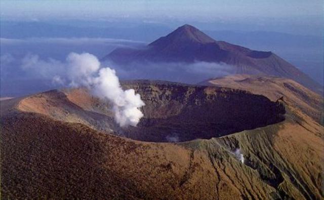 |
Figure 4. Steam from Shinmoe-dake at Kirishima looking towards the SE in 1991. Naka-dake is the adjacent cone with a flat top, and in the background is Ohachi (crater to the right), Takachiho-no-mine (the highest peak in the center), and Futatsuishi (left). Courtesy of T. Kagiyama, ERI. |
Table 1. Daily numbers of volcanic earthquake events at Kirishima, 5-15 November 1999. Courtesy of JMA.
| Date | Volcanic Earthquakes |
| 05 Nov 1999 | 0 |
| 06 Nov 1999 | 12 |
| 07 Nov 1999 | 16 |
| 08 Nov 1999 | 40 |
| 09 Nov 1999 | 81 |
| 10 Nov 1999 | 192 |
| 11 Nov 1999 | 128 |
| 12 Nov 1999 | 69 |
| 13 Nov 1999 | 86 |
Geological Summary. Kirishimayama is a large group of more than 20 Quaternary volcanoes located north of Kagoshima Bay. The late-Pleistocene to Holocene dominantly andesitic group consists of stratovolcanoes, pyroclastic cones, maars, and underlying shield volcanoes located over an area of 20 x 30 km. The larger stratovolcanoes are scattered throughout the field, with the centrally located Karakunidake being the highest. Onamiike and Miike, the two largest maars, are located SW of Karakunidake and at its far eastern end, respectively. Holocene eruptions have been concentrated along an E-W line of vents from Miike to Ohachi, and at Shinmoedake to the NE. Frequent small-to-moderate explosive eruptions have been recorded since the 8th century.
Information Contacts: JMA-Fukuoka, Japan Meteorological Agency (JMA), 1-3-4 Ote-machi, Chiyoda-ku, Tokyo 100, Japan; Setsuya Nakada and Tsuneomi Kagiyama, Volcano Research Center, Earthquake Research Institute, University of Tokyo, Yayoi 1-1-1, Bunkyo-ku, Tokyo 113, Japan (URL: http://www.eri.u-tokyo.ac.jp/VRC/index_E.html).