Report on San Cristobal (Nicaragua) — February 2000

Bulletin of the Global Volcanism Network, vol. 25, no. 2 (February 2000)
Managing Editor: Richard Wunderman.
San Cristobal (Nicaragua) Continued frequent eruptions and ashfall through December 1999
Please cite this report as:
Global Volcanism Program, 2000. Report on San Cristobal (Nicaragua) (Wunderman, R., ed.). Bulletin of the Global Volcanism Network, 25:2. Smithsonian Institution. https://doi.org/10.5479/si.GVP.BGVN200002-344020
San Cristobal
Nicaragua
12.702°N, 87.004°W; summit elev. 1745 m
All times are local (unless otherwise noted)
A new eruption began at about 2200 on 20 November 1999 (figure 4) with a series of explosions that caused ashfall near the volcano. More than 100 people were evacuated from the Hacienda Las Rojas. A commercial airline pilot reported that the ash plume reached about 2.4-3 km altitude. As of the start of this increased activity, the Nicaraguan Institute of Territorial Studies (INETER) reported that volcanic tremor and sporadic minor ash emissions had occurred for more than a year.
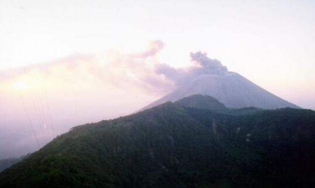 |
Figure 4. Photograph showing ash emissions from San Cristóbal on the afternoon of 21 November 1999. The view is from the top of Casita volcano, 4 km away. The dark part in the foreground is the edge of the Casita crater. Courtesy of Wilfried Strauch, INETER. |
The last previous significant eruptive activity at San Cristóbal began on the night of 19-20 May 1997 and spread fine ash on Chinandega, 18 km W (BGVN 22:05 and 22:06). On 30 October 1998 earth movements on the S flank of Casita volcano (4 km ESE of San Cristóbal) resulted from heavy hurricane rains, killing an estimated 1,560-1,680 people, with hundreds more displaced and several towns and settlements destroyed (BGVN 23:10). The following is based on INETER reports from November through the end of February 2000, with additional information based on crater visits in January and February and satellite imagery of a large eruption plume on 21 February.
Seismic tremor increased during the night of 19-20 November and quickly reached a maximum that was not matched at least through the end of December (figure 5). Tremor amplitude declined throughout 20 November, and then remained at levels of ~25-60% of the 20 November peak until a volcano-tectonic earthquake on 27 November.
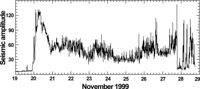 |
Figure 5. RSAM (real-time seismic amplitude measurement) data showing the relative amplitude of seismic tremor at San Cristóbal recorded at the seismic station near the Hacienda Las Rojas, at the foot of the volcano, 19-28 November 1999. Seismicity began during the night of 19-20 November, although volcanic activity at the surface was not reported until the following night of 20-21 November. Ashfall was reported at dawn on the 21st near the volcano. The high peak at 1520 on 27 November was caused by a volcano-tectonic earthquake. Courtesy of INETER. |
Small explosions preceded emissions on 22 November. Activity decreased after the initial eruptions, but a lack of winds caused the ash and gases to remain near the volcano. Concentrations of CO2 and SO2 measured on 22 November at three different sites exceeded the permissible limits established by the World Health Organization (WHO). INETER inspections showed that expelled gas and ash have been accumulating in local communities. However, on 23 November a slight increase in the wind speed facilitated the transport of volcanic material as far as the city of Chinandega 10 km to the SW. That day an observation post was established near the summit of Casita, where INETER staff could make visual observations and measurements of eruption column heights.
Ash emanations during 24-27 November varied in frequency, and the observer at Casita saw ash columns to heights of 100-300 m above the crater during the same period. At 0920 on 27 November a small earthquake (M 2.3) occurred ~2 km underneath the volcano. Volcanic gas monitoring on 24 November showed a significant increase in the concentrations of SO2 in the San Rafael and Las Rojas areas. However, the concentration of CO2 showed a diminution compared to 23 November. Concentrations of SO2 and CO2 decreased again on the 25th, although in some communities the level of SO2 remained unchanged. A correlation spectrometer (COSPEC) for measuring SO2 flux was brought from the INSIVUMEH of Guatemala on 26 November, with the support of the Coordination Center for the Prevention of Natural Disasters in Central America (CEPREDENAC).
Seismic tremor amplitude remained fairly stable, around 30-50% of the 20 November peak, during 26 November through 13 December. Seismicity fluctuated, with periods of higher and lower amplitude; a corresponding fluctuation in the ash-and-gas emissions was noted. The amounts of gases emitted by the volcano also showed this correlation, with SO2-flux values that oscillated between 100 and 1,000 tons/day.
By 2 December ash emissions had decreased considerably, although low-level gas emissions remained continuous. There was a slight increase in emissions on 4 December, but activity remained low through the 13th. Higher wind speeds during this period helped keep gas concentrations low in local towns. Seismic tremor began to rise the night of 12-13 December to a high of 70% of the previous peak. On 14 December small amounts of volcanic ash fell in Chinandega. Tremor amplitude returned to ~40% of the peak on 15 December, then decreased to 20-30% of the peak by dawn on the 16th.
Lahars on 16 December 1999. The Civil defense and local residents reported that a mass-flow on the NW side of the volcano on 16 December stopped ~2 km from populated areas. On 21 December, two specialists visited the affected Rancherías region NW of San Cristóbal in the Municipality of Chinandega (Dpto. Chinandega) to investigate the event. According to the meteorological station of Chinandega, 7.9 mm of rain fell from 1824 until 2012; in the first hour strong rains were reported, and from 1920 there were light to moderate rains. Previous strong rains have produced erosion gullies on the slopes of the volcano.
Due to the recent eruptive activity, large amounts of ash and lapilli had accumulated in these gullies; these were mobilized by the rains into lahars. Several sources were identified between 1,400 and 1,500 m elevation. The mobilized material formed a debris flow containing ash and lapilli that carried blocks varying from centimeters to meters in size. The flow quickly cemented into an extremely hard deposit. The material eroded from the highest slopes of San Cristóbal moved along one main gully, leaving a very deep channel and, below 500 m elevation, an extended lobate deposit that reached within ~2 km of the community of Ranchería. The main flow had a length of ~7 km and variable widths between 10 and 150 m; deposit thickness varied from less than 10 cm up to 2 m at the terminus.
Similar events happened on the S slope of the volcano that same day. At least five lahars were visible from the Leon-Chinandega highway.
Minor ash emissions continue. Activity remained consistently low and unchanged until noon on 28 December when earthquakes began. These were centered SE of Casita with magnitudes between 2 and 3.5 and depths of a few kilometers. The occurrence of earthquakes near San Cristóbal is a new phenomenon in the current eruption. Ash emission also increased and small amounts fell in Chinandega.
Seismic tremor on 29 December increased to as high as 40% of the 20 November peak. Small amounts of ash fell in Chinandega and El Viejo. No significant changes in activity were noted on 30 December. Moderate ashfalls were reported near the volcano and in Chinandega. Depending on the wind direction, ashfall sporadically reached the communities of Higueral, 10.5 km NE, and Pelona, 9 km E.
Activity during January-February 2000. Small explosions continued during January with ash and gas emissions (figure 6) and 4,444 registered volcanic earthquakes. Seismicity was higher in the first 17 days of January, but the seismic tremor (RSAM) stayed constant. Between 17 and 23 February activity increased, causing significant ashfall in Chinandega. The number of registered volcanic earthquakes in February was of 1,784.
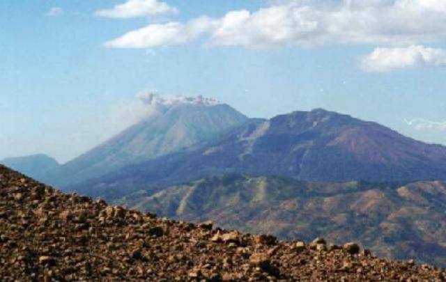 |
Figure 6. Ash emissions from San Cristóbal on 13 January 2000. The view is from the summit of Telica volcano. Courtesy of INETER. |
Alain Creusot visited the crater on 10 January and observed rhythmic, phreatic explosions, which included rock ejections and ash columns from three vents. At 0600 that day, a violent explosion threw bombs high above the crater rim. Creusot visited the crater again on 4 February and observed a 50-cm-deep ash layer over the crater area and 30-cm depths over the entire summit. Rhythmic phreatic explosions continued and new bombs were observed and sampled on the E crater rim (figure 7). These bombs apparently originated from a Strombolian explosion on 30 January. A third visit on 20 February showed a 1-m-deep ash layer in the crater area and 50-cm depths elsewhere in the summit area. Rocks 50 cm in size had been ejected.
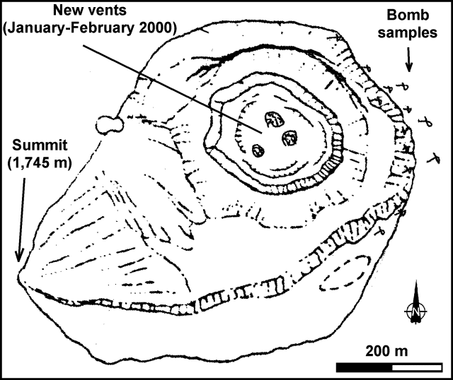 |
Figure 7. Sketch map of the San Cristóbal summit area showing the new vents within the crater and locations of bombs deposited following an explosion on 30 January 2000. Courtesy of Alain Creusot. |
Benjamin van Wyk de Vries noted that GOES images on 21 February showed a long plume extending from San Cristóbal to ~100 km over the Pacific Ocean. He also reported that this was the strongest ash eruption at San Cristóbal since the 1997 eruption. At 1100 on 24 February, a violent explosion threw bombs over the entire summit. A similar explosion and effects occurred at 0900 on the 25th.
Geological Summary. The San Cristóbal volcanic complex, consisting of five principal volcanic edifices, forms the NW end of the Marrabios Range. The symmetrical 1745-m-high youngest cone, named San Cristóbal (also known as El Viejo), is Nicaragua's highest volcano and is capped by a 500 x 600 m wide crater. El Chonco, with several flank lava domes, is located 4 km W of San Cristóbal; it and the eroded Moyotepe volcano, 4 km NE of San Cristóbal, are of Pleistocene age. Volcán Casita, containing an elongated summit crater, lies immediately east of San Cristóbal and was the site of a catastrophic landslide and lahar in 1998. The Plio-Pleistocene La Pelona caldera is located at the eastern end of the complex. Historical eruptions from San Cristóbal, consisting of small-to-moderate explosive activity, have been reported since the 16th century. Some other 16th-century eruptions attributed to Casita volcano are uncertain and may pertain to other Marrabios Range volcanoes.
Information Contacts: Wilfried Strauch and Virginia Tenorio, Dirección General de Geofísica, Instituto Nicaragüense de Estudios Territoriales (INETER), Apartado 1761, Managua, Nicaragua (URL: http://www.ineter.gob.ni/); Alain Creusot, Instituto Nicaraguense de Energía, Managua, Nicaragua (URL: http://www.ine.gob.ni/); Benjamin van Wyk de Vries, Departement des Sciences de la Terre, Universite Blaise Pascal, 63038 Clermont-Ferrand, France.