Report on Toya (Japan) — March 2000
Bulletin of the Global Volcanism Network, vol. 25, no. 3 (March 2000)
Managing Editor: Richard Wunderman.
Toya (Japan) Eruptions began on 31 March and proceeded from multiple craters on the NW flank
Please cite this report as:
Global Volcanism Program, 2000. Report on Toya (Japan) (Wunderman, R., ed.). Bulletin of the Global Volcanism Network, 25:3. Smithsonian Institution. https://doi.org/10.5479/si.GVP.BGVN200003-285030
Toya
Japan
42.544°N, 140.839°E; summit elev. 733 m
All times are local (unless otherwise noted)
Following several days of increased seismicity, an eruption of Usu volcano began on 31 March. The eruption, the first at Usu since 1977-82, was continuing in April. This report is based on information compiled from a wide variety of sources cited in the text by Setsuya Nakada at the Volcano Research Center, University of Tokyo. Vigorous activity continued through April, and by the end of the month there were more than 50 craters; details will be provided in the next Bulletin.
Precursory activity. The number of volcanic earthquakes around Usu began increasing after 0800 on 27 March, prompting a series of Volcano Advisory notices from the Japan Meteorological Agency (JMA). At the site of the seismic station, ~2 km S of the summit, there were 16 earthquakes recorded on 27 March, followed by 599 (including 68 felt earthquakes) on the 28th (table 5). Neither volcanic tremor nor visible change in fumarolic gas had been observed by the night of 28 March.
Table 5. Numbers of earthquake events at Usu during 27 March-4 April 2000. The JMA seismometer is located ~2 km S of the summit. Courtesy of JMA.
| Date | Volcanic | Low-frequency | Felt | Tremor |
| 27 Mar 2000 | 16 | 0 | ? | 0 |
| 28 Mar 2000 | 599 | 5 | 68 | 0 |
| 29 Mar 2000 | 1629 | 164 | 600 | 0 |
| 30 Mar 2000 | 2454 | 326 | 537 | 0 |
| 31 Mar 2000 | 788 | 139 | 299 | 0 |
| 01 Apr 2000 | 159 | 24 | 52 | 0 |
| 02 Apr 2000 | 48 | 3 | 3 | 0? |
| 03 Apr 2000 | 22 | 0 | 2 | 0? |
| 04 Apr 2000 | 9 | 0 | 1 | 0? |
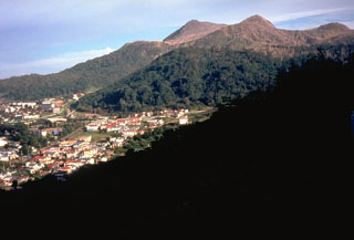
On the evening of 28 March the National Coordination Committee of Volcanic Eruption Prediction (chaired by Yoshiaki Ida, Univ. of Tokyo) warned about the high possibility of an imminent eruption. JMA also called resident's attention to the hazard of mudflows triggered due to snow melting during an eruption. A hot spring resort at the N foot of the volcano had about 1,600 guests this night. However, more than 400 persons living around the volcano voluntarily evacuated by the night of 28 March.
A Volcano Alert was issued by JMA on the morning of 29 March. That day the number of volcanic earthquakes totaled 1,629 (600 of them felt), including low-frequency earthquakes whose number increased with time. At 0708 on 29 March a M 3.4 had a hypocenter on the N slope. Later that day, at 1722, one of M 4.2 was centered on the NW slope; analysis indicated faulting along a nearly vertical slip plane. The GPS network around the volcano, maintained by the Geographical Survey Institute (GSI), detected inflation. Neither volcanic tremor nor visible changes in fumarolic gas had been observed yet. People living in a city and two towns around the volcano were required to evacuate on the afternoon of 29 March. By that night, more than 9,000 people evacuated, including all tourists in resorts at the N foot of the volcano.
The number of volcanic earthquakes continued to increase on 30 March, to a total of 2,454, including 326 low-frequency earthquakes and 537 felt events. During a helicopter flight, Yoshio Katsui and Hiromu Okada (Hokkaido University) found chains of cracks as long as 100 m along the NW part of the caldera rim, just above the hypocenters of the volcanic earthquakes. A group of geologists from the same university, the Geological Survey of Japan (GSJ), and the Geological Survey of Hokkaido also found small cracks and signs of ground deformation at the N-NW foot of the volcano. The hot-spring resort on the S shore of Lake Toya, Toyako-Onsen, lies within the area that these phenomena were observed. The Usu Volcano Observatory of Hokkaido University, at the N foot of the volcano, was moved ~8 km S to the western part of Date City. Frequency and magnitude of earthquakes changed in a manner similar to that seen in the 1910 eruption; that event started with a phreatic eruption after 5 days of precursory phenomena. This was followed by explosions from 45 craters aligned along a 2.7-km-long, EW-trending zone. The 1910 eruption ended with a 3-month period of cryptodome emplacement.
Eruptions begin on 31 March. At 1310 on 31 March a phreatic eruption ~4 km NW of the summit and ~2 km NE of the epicenters of the volcanic earthquakes sent ash 3,200 m above the crater. Ash and cinders from the newly formed craters fell on nearby houses. After about 2 hours of strong ash emissions the eruption declined. No injuries were reported. According to Yoshio Katsui, who did a helicopter inspection, five craters formed successively that joined into one larger crater (roughly 200 m long and 60 m wide) during this eruptive episode.
According to the Joint University Research Group (JURG) on the morning of 31 March, additional cracks were observed in the W flank of the volcano, and on the summit of the old lava dome within the caldera. Cracks found the previous day on the NW flank and foot of the volcano became wider. Seismicity had decreased from the previous day.
According to a Volcano Advisory at 0312 on 1 April, a M 4.8 earthquake occurred, the largest so far during this eruption. Observations using a JMA camera indicated that another phase of the eruption started at the W foot around 0250, when explosions formed new craters near the previous craters W of Nishi-yama and also 1.5 km NE, on Konpira-yama. The latter were close to houses in the resort on the shore of Lake Toya. Cock's-tail-shaped jets were frequently observed from the active craters. Sometimes eruption clouds rose more than 2 km above the vents. According to Tadahide Ui, petrological work in Hokkaido University identified a few juvenile fragments in the products of the first eruption. Takayuki Kaneko (VRC, U. Tokyo) inspected the craters from the Asahi Shinbun news helicopter on 1 April (figure 21 and table 6).
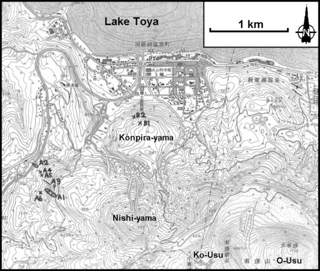 |
Figure 21. Topographic map of the NW sector of Usu, showing the distribution of new craters in the Nishi-yama and Konpira-yama dome areas, 1 April 2000. The summit, on the O-Usu dome, is at the lower right. Craters are numbered in the order of their opening. Courtesy of Takayuki Kaneko. |
Table 6. Venting from west of Nishi-yama dome (craters A1-A6) and near Konpira-yama dome (craters B1-B2) at stated times on 1 April 2000, as seen from helicopter by Takayuki Kaneko (VRC, U. Tokyo). Craters formed in the same order as their numbers, but the opening sequence of A4 and A5 was unclear.
| Crater | Status on 1 April (1110-1130) | Status on 1 April (1310-1330) |
| A1 | Inactive | Inactive |
| A2 | Active (white-to-dark cloud) | Active (white) |
| A3 | Active (dark) | Active (dark) |
| A4 | Not open | Active (white) |
| A5 | Not open | Active (white) |
| A6 | Not open | Activity began (white) |
| B1 | Not open | Active (white) |
| B2 | Not open | Activity began (white) |
According to the JURG and the GSJ, deformation on the NW part of the volcano continued. During 31 March to 1 April, with respect to the volcano's foot, the NW caldera rim uplifted by as much as 30 cm a day and migrated NE by 25 cm over a period of 19 hours. Small crack systems observed in the N foot also supported some slow but continual migration on the NW part of the volcano.
The GSJ and Hokkaido University noted that on 2 April fresh pumice fragments floated in Toya Lake, ~3.7 km ENE of the 31 May eruption vent. Three faults extending E-W for a few hundred meters were seen on 3 April near the explosion craters (NW of Nishi-yama). The maximum throw of the faults was ~10 m. They form a normal fault system with subsidence in the N side according to Kiyoaki Niida of Hokkaido University. A new fault system was found on 4 April a few hundred meters N of the one near the craters NW of Nishi-yama, according to Okada, and the area between the two fault systems was subsiding to form a graben. In early April, the fracture, which formed near the NW part of the summit caldera rim on 30 March, widened to ~4-5 m. The eruptive activity continued and the Asahi newspaper reported that at 1700 on 4 April at least one new crater lying between the two existing groups of craters sent a white plume 600 m high.
A new crater formed on the morning of 5 April on Konpira-yama near the previous two craters and sent a grayish plume to ~400 m height, according to JMA. On the W slope of Konpira-yama, a mudflow moved down slowly toward the spa, raising steam.
The main edifice consists of basaltic to basaltic-andesites (49-53% SiO2) with a small summit caldera. Ten dacitic lava or cryptodomes (68-73 % SiO2) lie on the summit and N slope arranged in two lines trending NW-SE. The eruptions that occurred at the summit (in 1663, 1769, 1822, 1853 and 1977-82) commenced with a strong Plinian phase and, apart from 1977-82, were accompanied by pyroclastic flows. All but perhaps the 1769 eruption also involved the growth of lava or cryptodomes in the middle to final stages. Both summit (O-Usu and Ko-Usu) and flank (Showa-Shinzan) lava domes, along with seven cryptodomes, were erupted in historical time. The war-time growth of Showa-Shinzan was painstakingly documented by the local postmaster, who created the first detailed record of lava-dome growth.
During the flank eruptions (in 1910 and 1943-45) the building of lava or cryptodomes was preceded by phreatic explosions in the initial stage. Each eruption lasted from one month to two years, with between thirty and one hundred years of repose between them. According to Akihiko Tomiya (Geological Survey of Japan), precursory seismicity of the historical eruptions (mainly volcanic earthquakes) lasted from 32 hours (1977-82) to 6 months (1943-45).
Geological Summary. Usuzan, one of Hokkaido's most well-known volcanoes, is a small stratovolcano located astride the southern topographic rim of the 110,000-year-old Toya caldera. The center of the 10-km-wide, lake-filled caldera contains Nakajima, a group of forested Pleistocene andesitic lava domes. The summit of the basaltic-to-andesitic edifice of Usu is cut by a somma formed about 20-30,000 years ago when collapse of the volcano produced a debris avalanche that reached the sea. Dacitic domes erupted along two NW-SE-trending lines fill and flank the summit caldera. Three of these domes, O-Usu, Ko-Usu and Showashinzan, along with seven crypto-domes, were erupted during historical time. The 1663 eruption of Usu was one of the largest in Hokkaido during historical time. The war-time growth of Showashinzan from 1943-45 was painstakingly documented by the local postmaster, who created the first detailed record of growth of a lava dome.
Information Contacts: Volcano Research Center, Earthquake Research Institute, University of Tokyo, Yayoi 1-1-1, Bunkyo-ku, Tokyo 113-0032, Japan (URL: http://www.eri.u-tokyo.ac.jp/VRC/index_E.html); Geological Survey of Japan, 1-1-3 Higashi, Ibaraki, Tsukuba 305, Japan (URL: https://www.gsj.jp/); Usu Volcano Observatory, Institute of Seismology and Volcanology, Graduate School of Science, Hokkaido University, Sohbetsu-cho, Usu-gun, Hokkaido, 052-0103, Japan (URL: http://www.sci.hokudai.ac.jp/isv/english/); Japan Meteorological Agency, Volcanological Division, 1-3-4 Ote-machi, Chiyoda-ku, Tokyo 100, Japan.