Report on Yellowstone (United States) — May 2000
Bulletin of the Global Volcanism Network, vol. 25, no. 5 (May 2000)
Managing Editor: Richard Wunderman.
Yellowstone (United States) On 2 May powerful Steamboat geyser discharged over 190 m3 of water
Please cite this report as:
Global Volcanism Program, 2000. Report on Yellowstone (United States) (Wunderman, R., ed.). Bulletin of the Global Volcanism Network, 25:5. Smithsonian Institution. https://doi.org/10.5479/si.GVP.BGVN200005-325010
Yellowstone
United States
44.43°N, 110.67°W; summit elev. 2805 m
All times are local (unless otherwise noted)
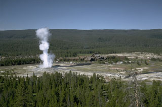
Yellowstone's Norris basin (White and others, 1988) includes the powerful but erratic Steamboat geyser. Steamboat suddenly ejected a vigorous plume of boiling water and steam on the morning of 2 May 2000. For 9 years prior to this-since 2 October 1991-it ejected only modest water discharges to heights under 20 m. This report discusses the basic observations surrounding the outburst, the minimum volume of the water discharged, and some collateral changes seen at neighboring Cistern Spring.
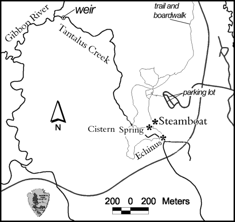
Shaken campers. Around 0700, National Park Service (NPS) employee Bob Lindstrom stopped at Norris to investigate an anomalously tall vapor column. Two park visitors, who had spent the night sleeping in their camper pickup truck in the otherwise deserted Norris parking area (figure 5), told him that they were abruptly awakened about 0500. The campers had felt the ground trembling as their truck started rocking, an effect they mistook for an earthquake. Frightened, they initially drove away, but upon looking back they saw a huge vapor plume and returned to Norris.
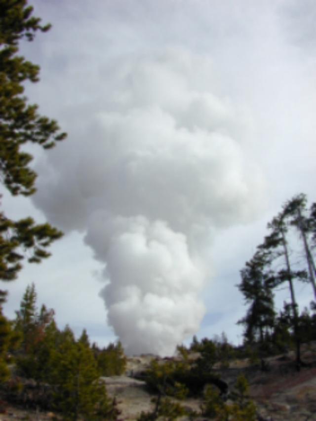
By 0700 when Lindstrom arrived, a wet mist enveloped most of the area around Steamboat geyser; it appeared as local rainfall, even though elsewhere the sky remained blue. The subfreezing air temperature caused ice to form where water fell on the boardwalks running out to the geysers. Discharging steam emitted a jet-engine-like roar. Steamboat was in full steam phase, with a vapor plume then approximately 150 m tall. Although the campers took early photos not yet available to the Park, other photos were taken during the steam phase of the outburst (figure 6). The loud roaring associated with the steam phase continued unabated through at least 0800 and other sources said noises remained audible at 1100 on 2 May. According to Paul Strasser, the outburst left rocks and sand on atop the bridge over the eastern runoff channel at the base of the hill.
Water runoff. To study changes in the Norris basin, for the past 12 years Irving Friedman has monitored the output of a small creek that drains the basin, ~2 km from Steamboat and Echinus geysers (Tantalus creek, figure 5). His efforts have been substantively aided by NPS support and collaboration in addition to help from a cadre of volunteers.
Tantalus creek's discharge gets measured at a small dam with a notch of known dimension (a weir). The height of the water passing through the weir relates to the stream discharge. The water height gets measured by a float gauge similar to those in automobile fuel tanks. The float's position gets recorded every 10 minutes by a data logger. The 10-minute sampling rate means that the instrumentation can only be expected to reflect behavior with periods over 20 minutes; signal processing theory suggests shorter processes can be aliased (i.e., biased leading to misleading results). Since each of the outburst's two phases each lasted over an hour, the sampling interval appears to have been adequate to describe the two phases.
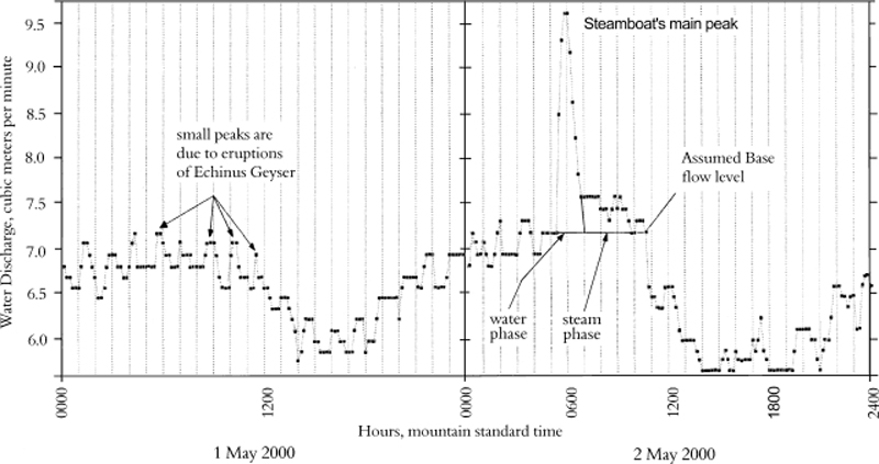
As shown on figure 7, the 1 and 2 May weir data show runoff changing in a long-period cycle somewhat over 20 hours in length, with the Steamboat peak on 2 May superimposed on or near the peak of this long-period cycle. Similar long-period runoff cycles occur often in the weir data, but their cause has not been identified.
The weir data on 1 May and during parts of 2 May showed the typical behavior seen in the basin, in this case with Echinus runoff producing repeated peaks with a range of 0.5-1.7 hours and a mean of ~1.1 hours. Ignoring the interval where the Echinus data became masked by the much larger Steamboat peak, the weir data on 2 May was similarly dominated by Echinus runoff; in this case showing peaks with a range of 0.5-3 hours and a mean of ~1.1 hours.
The strong 2 May discharge at Steamboat furnished runoff that arrived at the weir at about 0520 (figure 7). Friedman estimated that the travel time for water from Steamboat to the measuring weir to be about 20 to 30 minutes, so the outburst must have occurred at about 0500. Within the limitations of the instrumental data at the weir, the discharge reached its apex at 0600.
The water phase of the outburst lasted 40 to 60 minutes, reaching a recorded peak discharge rate of ~10 m3 per minute.
The total amount of water discharged during the outburst can be calculated, giving a minimum estimate of the discharge during the outburst. The calculation was made using the area under the curve from the assumed base flow (figure 7).
In addition, figure 7 shows how Friedman broke the Steamboat outburst into a water-dominated phase and a later steam-dominated phase. For the water phase, the weir discharged ~150 m3 (150,000 Liters); for the steam-phase, ~36 m3 (36,000 ,. In addition to the measured runoff, a large, but unknown amount of steam and condensate escaped into the atmosphere; other losses included water stored in places such as soil, ponded on the surface, etc.
Friedman also discusses several representative day-long intervals of weir data, such as 21 September 1998, a day when small but regular peaks of ~0.4 m3/s occurred almost hourly, caused by the outbursts at Echinus geyser. Similar, though less regular patterns persisted in some of the later data. Unfortunately, an electrical connection corroded and broke electrical continuity, halting data collection during the interval early February-May 1999.
During this interval without instrumental record, changes occurred at Norris: a) approximately 1 km from Echinus a new thermal area emerged; b) Echinus's period between outbursts became less regular; and c) the outbursts varied in duration and size, sometimes becoming absent from the record. It is possible that this emergent thermal area robbed Echinus of some of its water and heat. How or whether this helped drive Steamboat towards its 2 May outburst remains uncertain.
Collateral observations. NPS literature states that Cistern Spring's water supply has been closely associated with Steamboat geyser: "When Steamboat erupts, Cistern Spring slowly drains." This pattern prevailed in the 2 May outburst. At 1100 on 2 May the surface water in Cistern Spring was ~8 cm below overflow. By 1900 on 2 May, it had dropped by 1.2 m. By 0900 on 3 May, Cistern Spring was empty; a photo around that time showed Steamboat's continuing steam phase with a plume tens of meters tall.
In reporting recent geyser news on the Geyser Observation and Study Association (GOSA) web page, Paul Strasser noted that eight days prior to the minor outbursts, water gushed mainly from Steamboat's S vent, but occasionally gushed at its N vent, a pattern similar to the mode of activity seen last year. Strasser also noted some possible precursory effects. After the outburst, visitors allegedly told NPS staff that on 29 and 30 April they had seen water from both vents reaching 12-18 m high and felt a larger outburst might start.
Naturalist John Tebby told Strasser that on 1 May he saw the minor discharges starting from both of Steamboat's vents, but only to ~2 m high; a modest amount of runoff came from the S vent. He was only in the vicinity for a short time. Intriguingly, Cistern Spring was then in heavy boil to depths of 15-20 cm, apparently having heated up.
Background. The following comes from GOSA's descriptive list of Yellowstone's 182 geysers: "Steamboat Geyser is currently the tallest geyser in the world. Its major eruptions [discharges] can soar to nearly 400 feet [120 m]. Unfortunately, its major eruptions [discharges] are rare and erratic. Intervals between majors have ranged from 4 days to 50 years. More common is its minor activity that consists of splashes or small discharges every few minutes. This minor play can reach 30 feet [9 m] or more."
"Steamboat is a cone-type geyser erupting [discharging] from two main vents. The water phase of a major eruption [outburst] lasts from 3 to 20 minutes and is followed by an extremely loud steam phase that can continue for another 12 hours. The water phase emits a large amount of water. The aftermath of which can easily be seen around the geyser . . . [sound intensity] of the steam phase has been described as painful . . . [audible] miles away."
According to the Yellowstone Public Affairs office, Steamboat was dormant from 1911-1961. In recent years, Steamboat has had major discharges in 1989 (three events), 1990 (one event), and 1991 (one event).
Strasser discusses how during 1982-84 Steamboat produced numerous short-interval minor discharges, whereas during 1979 only one outburst took place. Strasser and others (1989) cite more references than shown here.
References. Whittlesey, Lee, 2000, Full steam ahead: Steamboat Geyser erupts!: The Buffalo Chip (a Yellowstone National Park employee resource-management newsletter) (Spring, 2000).
Strasser, P., Strasser, S., and Pulliam, B., 1989, Investigations of patterns of minor behavior of Steamboat geyser, 1982-1984: Geyer Observation and Study Association Transactions, v. 2, p. 43-70 (see GOSA website).
White, D.E., Hutchinson, R.A., and Smith, T.E.C., 1988, The geology and remarkable thermal activity of Norris Geyser Basin, Yellowstone National Park, Wyoming: U.S. Geological Survey Professional Paper 1456, U.S. Government Printing Office.
Geological Summary. The Yellowstone Plateau volcanic field developed through three volcanic cycles spanning two million years that included some of the world's largest known eruptions. Eruption of the over 2,450 km3 Huckleberry Ridge Tuff about 2.1 million years ago created the more than 75-km-long Island Park caldera. The second cycle concluded with the eruption of the Mesa Falls Tuff around 1.3 million years ago, forming the 16-km-wide Henrys Fork caldera at the western end of the first caldera. Activity subsequently shifted to the present Yellowstone Plateau and culminated 640,000 years ago with the eruption of the over 1,000 km3 Lava Creek Tuff and the formation of the present 45 x 85 km caldera. Resurgent doming subsequently occurred at both the NE and SW sides of the caldera and voluminous (1000 km3) intracaldera rhyolitic lava flows were erupted between 150,000 and 70,000 years ago. No magmatic eruptions have occurred since the late Pleistocene, but large hydrothermal events took place near Yellowstone Lake during the Holocene. Yellowstone is presently the site of one of the world's largest hydrothermal systems, including Earth's largest concentration of geysers.
Information Contacts: Bob Lindstrom and Ann Rodman, Yellowstone National Park, Wyoming 82190 USA; Irving Friedman, U.S. Geological Survey, P.O. Box 25046, MS 963, Denver, CO 80225 USA; Geyser Observation and Study Association (GOSA), care of Janet & Udo Freund, 39237 Yellowstone St., Palmdale, CA 93551 USA (URL: http://www.geyserstudy.org/).


