Report on Cameroon (Cameroon) — June 2000
Bulletin of the Global Volcanism Network, vol. 25, no. 6 (June 2000)
Managing Editor: Richard Wunderman.
Cameroon (Cameroon) Explosive eruptions and a lava flow from two vents starting on 29 May
Please cite this report as:
Global Volcanism Program, 2000. Report on Cameroon (Cameroon) (Wunderman, R., ed.). Bulletin of the Global Volcanism Network, 25:6. Smithsonian Institution. https://doi.org/10.5479/si.GVP.BGVN200006-224010
Cameroon
Cameroon
4.203°N, 9.17°E; summit elev. 4095 m
All times are local (unless otherwise noted)
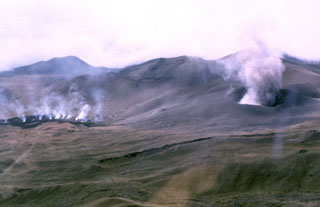
Mt. Cameroon began erupting during the night of 28 May 2000. On 29 May, following a violent explosion, red-tinged fumaroles were observed at an elevation of 3,300 m. On May 30, an earthquake shook the provincial capital of Buea, located to the SE of the volcano. Volcanic ash and gases that were vented during the course of the eruption were blown to the W coast by NE winds.
The eruption occurred at two principle sites separated by 3 km. These sites lie on the central portion of the upper SE flank, upslope of the town of Buea and in the vicinity of vents active in 1904 and 1922. The first site, located at latitude 04°12'40" N and longitude 09°10'45" E and an elevation of 4,000 m, is composed of two craters aligned NE to SW. Juvenile material comprises less than 1% of the total volume of the pyroclastic material surrounding the vents. The larger pyroclasts were found farther away from the vent, while the finer material was deposited closest to the crater. The NE crater, with slopes that are fissured and unstable, showed relatively little activity compared with its neighbor to the SW. The eruption at the SW crater was characterized by sporadic explosions of gas and pyroclastic materials, including juvenile materials such as volcanic bombs, blocks, and scoria. There were no lava flows reported from this site.
The second vent lies at 04°11'15" N and 09°10' E at an elevation of 3,300 m. This site consists of a large open fissure oriented at N 40° E. The following features at the site run NE to SW along the fissure: two lava lakes surrounded by spatter cones, two craters in the process of forming cones with fluid lava, and several hectometer-sized (104 m2) fissure lava flows. The spatter cones are about 40 m from the associated lava lake.
The NE lava lake forms a 60 x 40 m ellipse. This lava lake was the source of the lava flows that moved towards the ocean to the S and away from many of the inhabited parts of the volcano's flanks. There were sporadic explosions at the lava lakes.
Contrary to some media reports that suggested the lava was advancing at rates up to 20-25 m/hour, a scientist from the Ministry of Territorial Administration reported that the lava moved at ~5 m/hour. The scientist also indicated that the lava flows were far from populated areas.
However, on 8 June, various news reports placed the lava flows within 5-7 km of the town of Buea. Reuters reported on 9 June that geologist Isaac Konifer Nijah, a member of a scientific team monitoring the volcano, considered the Buea area a high risk zone. Concern for the residents in this town prompted an evacuation plan for ~3,000 residents to the towns of Limbe to the SW and Tiko to the SE. However, the evacuation plan was not implemented because on 10 June the lava front halted its advance on the town.
The BBC reported that on 19 June, the Prime Minister of Cameroon, Peter Mafany Musonge, visited the village of Bokwango, which is on the outskirts of Buea. News reports stated that at this point the lava flows were 4 km from the edge of the village. However, no new activity had been reported by seismologists for several days preceding the visit.
Thanks to Pierre Vincent and the company ELF Aquitaine, an initially proprietary report on Mount Cameroon geology, eruptions, and hazards (including a geological map) were recently made available to the Smithsonian (Vincent, 1980). The same author has some earlier published work on this volcano (Vincent, 1971).
References. Vincent, Pierre M., 1980, GNL Project in Cameroon, geology and volcanology of Mount Cameroon: Report for ELF Aquitaine (in French), 11 p., appendices, and map (plate).
Vincent, Pierre M., 1971, New data about Cameroon Mountain volcano: 6th Colloquium on African Geology, Leicester, UK, April 1971, Jour. Geol. Soc. London 127, p. 414-415.
Geological Summary. Mount Cameroon, one of Africa's largest volcanoes, rises above the coast of west Cameroon. The massive steep-sided volcano of dominantly basaltic-to-trachybasaltic composition forms a volcanic horst constructed above a basement of Precambrian metamorphic rocks covered with Cretaceous to Quaternary sediments. More than 100 small cinder cones, often fissure-controlled parallel to the long axis of the 1400 km3 edifice, occur on the flanks and surrounding lowlands. A large satellitic peak, Etinde (also known as Little Cameroon), is located on the S flank near the coast. Historical activity was first observed in the 5th century BCE by the Carthaginian navigator Hannon. During historical time, moderate explosive and effusive eruptions have occurred from both summit and flank vents. A 1922 SW-flank eruption produced a lava flow that reached the Atlantic coast, and a lava flow from a 1999 south-flank eruption stopped only 200 m from the sea. Explosive activity from two vents on the upper SE flank was reported in May 2000.
Information Contacts: US State Department, 2201 C St., NW, Washington, DC 20520 USA (URL: http://www.state.gov/); BBC (URL: http://news.bbc.co.uk/); Reuters (URL: http://www.reuters.com).