Report on Miyakejima (Japan) — June 2000
Bulletin of the Global Volcanism Network, vol. 25, no. 6 (June 2000)
Managing Editor: Richard Wunderman.
Miyakejima (Japan) Magma intrusion within W flank and explosive eruption on 7 July
Please cite this report as:
Global Volcanism Program, 2000. Report on Miyakejima (Japan) (Wunderman, R., ed.). Bulletin of the Global Volcanism Network, 25:6. Smithsonian Institution. https://doi.org/10.5479/si.GVP.BGVN200006-284040
Miyakejima
Japan
34.094°N, 139.526°E; summit elev. 775 m
All times are local (unless otherwise noted)
The 27 June 2000 water discoloration ~1 km off the W shore of the island of Miyake-jima (BGVN 25:05) prompted considerable investigation. Remote Operation Vehicle (ROV) work and multi-beam side-scan sonar revealed fractures and what appeared to be three ocean-floor craters around the area of discoloration. Crustal deformation found in this region implies that cracks have opened under the W flank of the volcano. Magma intrusion was confirmed to have occurred in the W flank of the volcano around the time of the 27 June event. The absence of scoria or other eruptive products makes it likely that the event was thermal water released due to intrusion.
Magma intrusion is also thought to be the cause of a series of earthquakes that began on 26 June. Hypocenters migrated from a central position under the island in a curve to the W, NW, and N, reaching a position ~70 km NNW of the island by 21 July (figure 5).
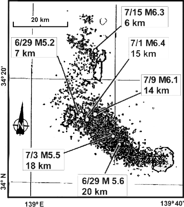 |
Figure 5. A map showing Miyake-jima (lower right-hand corner) and the NW migration of hypocenters, 26 June-21 July 2000. Hypocenters were centered under the summit when activity began and then migrated to a submarine location ~ 10 km NW. This movement was thought to be related to magma intruding to the W. Labels for the higher-magnitude events indicate the month/day, magnitude, and hypocenter depth. Courtesy of the Japan Meteorological Agency. |
Miyake-jima's mayor, Naoyuki Hirose, lifted the evacuation order for the SE district of Tsubota on 29 June, permitting hundreds of the almost 2,000 evacuees to return home. Approximately half of the island's population of 4,000 had been evacuated on 26 June.
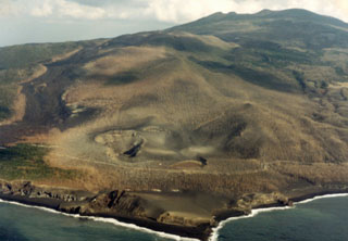
At 0414 on 7 July, an eruption from the summit crater sent ash and rock into the sky; plumes dispersed ash over wide areas of the island. The eruption continued until 1110 and about 140 residents had to be evacuated from the N sector of the island to protect them from heavy ashfall. A second eruption at 1550 sent an ash column 1 km above the crater, ejected rocks, and produced loud booming noises. On 8 July there was a weak yellow-colored emission. Closer inspection of this last eruption revealed that very little material had been ejected, but a pit crater ~200 m in diameter and 100-200 m deep had formed. It is thought that the pit crater marked an empty cavity left when magma progressed from the summit area and intruded to the W.
The month-long crisis (figure 5) involved more than 17,500 earthquakes, including 5,480 strong enough to be felt by humans. The Miyake-jima earthquake swarm included a 7 July, M 5.2 event centered 25 km NW of Miyake-jima under the young volcanic islands of Nii-jima and Kozu-shima at 10 km depth, and a 1 July, M 6.4 event that killed one man on Kozu-shima by rockfall.
Geological Summary. The circular, 8-km-wide island of Miyakejima forms a low-angle stratovolcano that rises about 1,100 m from the sea floor in the northern Izu Islands about 200 km SSW of Tokyo. The basaltic volcano is truncated by small summit calderas, one of which, 3.5 km wide, was formed during a major eruption about 2,500 years ago. Numerous craters and vents, including maars near the coast and radially oriented fissure vents, are present on the flanks. Frequent eruptions have been recorded since 1085 CE at vents ranging from the summit to below sea level, causing much damage on this small populated island. After a three-century-long hiatus ending in 1469 CE, activity has been dominated by flank fissure eruptions sometimes accompanied by minor summit eruptions. A 1.6-km-wide summit crater was slowly formed by subsidence during an eruption in 2000.
Information Contacts: Geological Survey of Japan, Higashi 1-1-3, Tsukuba, Ibaraki 305 Japan; Japan Meteorological Agency, Tokyo, Japan; Associated Press; Reuters.