Report on Kilauea (United States) — June 2000

Bulletin of the Global Volcanism Network, vol. 25, no. 6 (June 2000)
Managing Editor: Richard Wunderman.
Kilauea (United States) During May-July 2000, continued frequent surface flows and earthquakes
Please cite this report as:
Global Volcanism Program, 2000. Report on Kilauea (United States) (Wunderman, R., ed.). Bulletin of the Global Volcanism Network, 25:6. Smithsonian Institution. https://doi.org/10.5479/si.GVP.BGVN200006-332010
Kilauea
United States
19.421°N, 155.287°W; summit elev. 1222 m
All times are local (unless otherwise noted)
The period from 1 May through 17 July 2000 was characterized by frequent surface flows and earthquakes. On 9 May a thick steam and sulfur dioxide fume formed SW of Pu`u `O`o; such fumes, or vog, have often obscured the crater for the past few months. The prominent fumes came from skylights (holes in roofs of lava tubes) along the active tubes leading to a narrow dark aa flow that emerged onto the surface on 6-7 May.
On 15 May lava broke frequently onto the surface, widening the active flow field toward the E. During 16-25 May very little activity took place. On 26 May at 0457, heavy vog hung over Pulama pali and slowly drifted downslope. The ocean entry at Waha`ula remained vigorous over the past several weeks, building a bench 40-45 m seaward of the former coastline (figure 147).
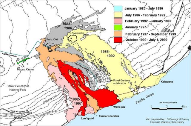 |
Figure 147. Map of Kīlauea showing lava flows (black) on Pulama pali and the coastal plain active since October 1999 through 1 July 2000, as well as flows erupted earlier from Pu`u `O`o and Kupaianaha. Courtesy of the USGS Hawaiian Volcano Observatory. |
On the afternoon of 29 May two successive earthquakes occurred on Kīlauea's S flank. The earthquakes had a preliminary magnitude of 4 and were felt in the town of Hilo 45 km NW of Kīlauea.
Observations of the Pu`u `O`o cone on 1 June revealed no significant changes in the crater or collapse pits on the S and W flanks (figure 148). On the E crater rim, gentle "sloshing" sounds were heard, indicating lava at a shallow level. Direct observation into the vent was prevented by heavy fume. The Pu`u `O`o crater contains three pond vents and two hornitos. Most of these originated during September-November 1999 intracrater activity. Since then the crater has often been obscured by fume, but occasionally HVO observers have witnessed active lava within these vents.
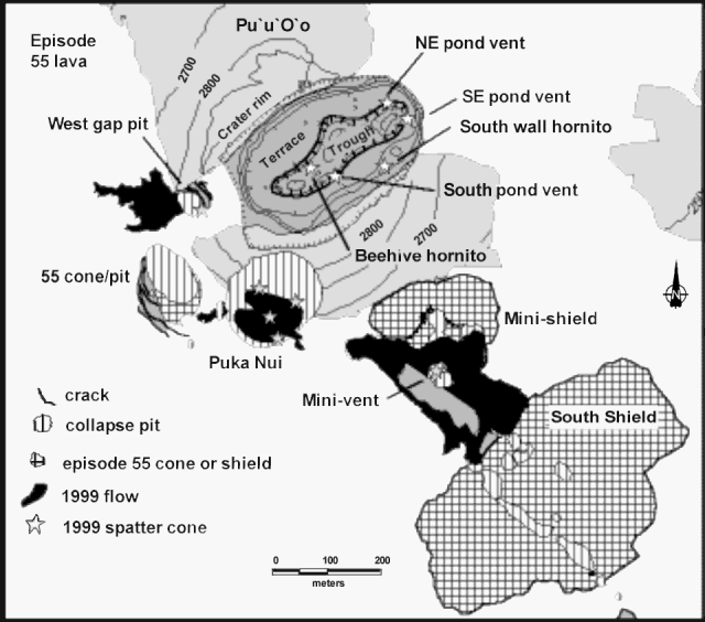 |
Figure 148. A diagram of the Pu`u `O`o cone and surroundings at Kīlauea as of March 2000 showing the area covered by lava since February 1997 during episode 55 (light gray). Inside the crater of Pu`u `O`o, the "trough" is the drained lava pond of September-October 1999. The central portion of the trough was briefly filled with active lava in February 2000. Puka Nui is the prominent collapse pit on the SW flank of Pu`u `O`o, which was floored with lava during September-October 1999. Puka Nui is a slowly expanding collapse crater that has consumed part of the tephra cone and surrounding shield on Pu`u `O`o's SW flank. Flank vents active in 1997 have built the south shield, minishield, and 55 cone. Courtesy of Steven Brantley and Christina Heliker, USGS Hawaiian Volcano Observatory. |
The S shield (figure 148) has about 20 m of relief; the minishield, less than 10 m. The episode 55 cone was about 10 m high; yet has subsided into a slowly expanding collapse crater. The cracks adjacent to the pit wall show the expansion of the 55 cone's pit. These cracks are as wide as 1-2 m and some have slight vertical offsets. Major subsidence occurs in abrupt stages. Entire collapse craters 10-30 m deep and 50 m across form in a few hours or less. The cracked ground then remains stable for weeks or months. The W gap, which formed in January 1997, is the result of the subsidence along the E-rift axis. An E-rift intrusion in September 1999 led to a temporary shutdown of volcanic activity at Pu`u `O`o. When activity resumed, new small spatter cones were active briefly, shedding the lava flows shown as 1999 flows on the sketch map.
Throughout the week of 11-17 June activity remained stable. Lava continued to flow to the sea from Waha`ula entry, and from the entry to its W. Surface lava flows were visible sporadically on Pulama pali and elsewhere. Volcanic tremor near Pu`u `O`o remained weak to moderate.
On 13 June rain cleared vog from Holei Pali and enabled good views of the flow field in the morning. Lava continued to enter the ocean, not only at the Waha`ula entry but also at other entries a few hundred meters to the W (figure 147). Surface flows were apparent several hundred meters inland, and visitors reported breakouts near the western edge of the present flow field for the past several days. Pulama pali remained dark, but the fumes rolling down the pali came from active lava tubes feeding the active ocean entries and surface breakouts. Due to rain clouds and volcanic gas in the crater center, Pu`u `O`o was dark on the morning of 14 June. Seismicity was low across the island. Volcanic tremor near Pu`u `O`o remained weak to moderate. Kīlauea's summit tilt and the tilt near and on Pu`u `O`o and all along the E rift zone were flat and stable.
Two moderate steam plumes rose from coastal entries on the afternoon of 15 June. Summit and rift-zone tilt remained steady, volcanic tremor at Pu`u `O`o was moderate and continued, and there was no unusual earthquake activity. Apparently on 15 June the eruption continued through tubes, with relatively little entering the sea.
On 16-17 June the lava bench at the Waha`ula entry was 30-50 m wide. On top of Pulama pali lava moved through the tube at a speed of ~10 km/hour. On 17 June, from 1330 to 1415, observations during a helicopter flight revealed more lava on the flow field a few hundred meters inland of Waha`ula. As movement of lava continued in Waha`ula, for the first time in several weeks a surface breakout was visible on Pulama pali between 1830 and 2030 on the evening of 17 June. The lava appeared from a distance to be aa and moved slowly down the middle third of the pali, near the eastern edge of the flow field W of Royal Gardens. On the evening of 17 June the Waha`ula entry , and another entry ~800 m to the W became active for several hours.
No breakouts were visible on 20 June on Waha`ula, Pulama pali, or the coastal flat. Fume continued to blanket the flow path down the pali. Above Pulama pali a new ledge was observed on 25 June, only ~1 m below the surface, at 642 m elevation. The ledge indicated that the level of lava in the tube rose temporarily and then subsided, and a breakout was observed at 686 m elevation.
During July there were frequent surface flows. On 6 July a substantial new pahoehoe flow began from a breakout point at about 200 m elevation on Pulama pali. The flow was ~500 m long and 150-200 m wide. Lava continued to spill into the sea at three sites. The most vigorous entry remained at Waha`ula, which generated two steam plumes on 6 July. The Kamokuna entry, the westernmost active bench, was less vigorous than Waha`ula but created a substantially larger steam plume. During mid-day 16 July, several entries were active: Waha`ula was the most active and Kamokuna the second most active. Several moderate-size surface flows were active in the eastern part of the flow field, between Royal Gardens and the coast. Heavy fume continued to flow down Pulama pali above the lava tube system.
Overall the seismicity and volcanic tremor for the months of May through July remained moderate and stable in the area around Kīlauea's summit. Within the summit of Kīlauea activity has remained slightly elevated.
Background. Kīlauea is one of five coalescing volcanoes that comprise the island of Hawaii. Historically its eruptions originate primarily from the summit caldera or along one of the lengthy E and SW rift zones that extend from the caldera to the sea. The latest Kīlauea eruption began in January 1983 along the E rift zone. The eruption's early phases, or episodes, occurred along a portion of the rift zone that extends from Napau Crater on the uprift end (towards the summit) to ~8 km E on the downrift end (towards the sea). Activity eventually centered on the area and crater that was later named Pu`u `O`o.
Between July 1986 and January 1992, the Kupaianaha lava lake was active ~3 km NE of Pu`u `O`o. It was during this period that the town of Kalapana and a majority of the 181 homes lost were destroyed. In December 1991, one month prior to the shutdown of Kupaianaha, eruptive activity returned to Pu`u `O`o. More than 1 km3 of lava has erupted during the 14 years of activity (January 1983-January 1997).
Geological Summary. Kilauea overlaps the E flank of the massive Mauna Loa shield volcano in the island of Hawaii. Eruptions are prominent in Polynesian legends; written documentation since 1820 records frequent summit and flank lava flow eruptions interspersed with periods of long-term lava lake activity at Halemaumau crater in the summit caldera until 1924. The 3 x 5 km caldera was formed in several stages about 1,500 years ago and during the 18th century; eruptions have also originated from the lengthy East and Southwest rift zones, which extend to the ocean in both directions. About 90% of the surface of the basaltic shield volcano is formed of lava flows less than about 1,100 years old; 70% of the surface is younger than 600 years. The long-term eruption from the East rift zone between 1983 and 2018 produced lava flows covering more than 100 km2, destroyed hundreds of houses, and added new coastline.
Information Contacts: Hawaiian Volcano Observatory (HVO), U.S. Geological Survey, PO Box 51, Hawaii National Park, HI 96718, USA (URL: https://volcanoes.usgs.gov/observatories/hvo/).