Report on Copahue (Chile-Argentina) — June 2000

Bulletin of the Global Volcanism Network, vol. 25, no. 6 (June 2000)
Managing Editor: Richard Wunderman.
Copahue (Chile-Argentina) Frequent ash explosions and acidic mudflows starting on 1 July
Please cite this report as:
Global Volcanism Program, 2000. Report on Copahue (Chile-Argentina) (Wunderman, R., ed.). Bulletin of the Global Volcanism Network, 25:6. Smithsonian Institution. https://doi.org/10.5479/si.GVP.BGVN200006-357090
Copahue
Chile-Argentina
37.856°S, 71.183°W; summit elev. 2953 m
All times are local (unless otherwise noted)
An eruption of Copahue (figure 5) began on 1 July 2000. Ash-and-gas emissions, which have continued into late July, are considered to be Copahue's most vigorous activity in the past century. Reports were received from geologists in Argentina and Chile. Except where otherwise noted, Argentine geologists Adriana Bermúdez (CONICET) and Daniel Delpino (Civil Defense of Neuquén Province) reported information for 1-9 July, and Chilean geologists José Naranjo and Gustavo Fuentealba (both of SERNAGEOMIN) reported information from 10-13 July. The scientists submitted joint reports beginning on 13 July. All time references are to Argentina local time; Chilean time is one hour earlier (GMT - 4 hours).
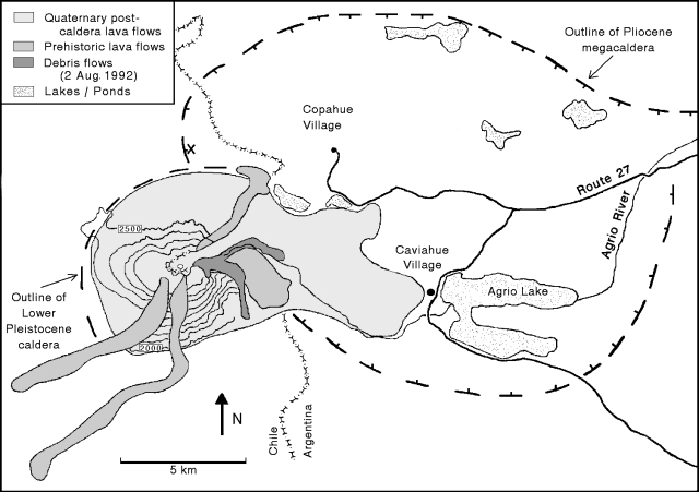 |
Figure 5. Preliminary geologic map of Copahue, showing outlines of Pliocene and Pleistocene calderas and post-caldera lava flows. Contour interval, 100 m. Modified from a previous map in BGVN 17:10. Courtesy of A. Bermúdez and D. Delpino. |
Initial explosions, 1-2 July. Although visibility was poor in late June, at 0030 and at 0430 on 1 July local Argentine police and gendarmerie (National Guard) reported ash mixed with heavy snowfall, as well as a strong sulfur smell. At around 1145, lapilli and ashfall became heavier, eventually covering the snow and the products of previous eruptions around the summit. At 1200 the gendarmerie reported lapilli falling 7.5 km NE of the volcano, in the village of Copahue, Argentina. The alert status was set at yellow; the village's emergency committee restricted tourist access and helped to evacuate 200 people.
Explosions continued throughout 2 July with increasing intensity. Lapilli, ash, and sporadic bombs (15 cm in diameter) fell 8-9 km E on the town of Caviahue, Argentina, with up to 15 cm of materials from the day's explosions eventually being deposited in some areas (figure 6). Until 2345 there were explosions of varying intensities. Preliminary results of an examination of the deposits revealed that they were composed of a very fine silica, sulfur particles, accidental rock fragments from the conduit, and juvenile materials. In Caviahue, visibility was practically zero due to ash particles in the air, and heavy ashfall cut off power for several hours. By midday, eruption plumes blowing SE reached Loncopué, a small village 50 km from the volcano.
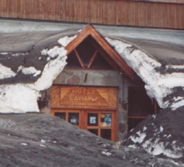 |
Figure 6. Ashfall from the frequent eruptions that began [1 July] at Copahue and heavy snowfall have affected the reliability of power and potable water resources in the town of Caviahue, a popular ski area 8-9 km E of the volcano. Although the town is no longer under official evacuation, many inhabitants have not returned to battle current conditions. Courtesy of A. Bermúdez and D. Delpino. |
Alert status was raised to orange on 2 July when ash was dispersed as far as 100 km away from the crater and the plume covered a total area of 2,000 km2. Maximum ash accumulation of 3-5 cm occurred over an area of 6 km2, including the town of Caviahue and the W sector of Lake Caviahue. Due to the ashfall, the surface of Lake Caviahue changed color from its normal deep blue to gray-green, and a water sample taken had a pH of 2.l.
Tests by Argentine geologists on ash samples deposited in Caviahue revealed a grain-size distribution of 15% coarse ash (> 1 mm), 80% fine ash (0.5-1.0 mm), and 5% fine ash dust (< 0.5 mm). The coarse ash contained a small quantity of juvenile and lapilli-sized (3-6 mm) accidental fragments; the juvenile materials were dark gray vitric scoria. Non-juvenile accessory materials accounted for 7-10% of the coarse ash and consisted primarily of white-gray silica from the bottom of the crater lake. The fine ash-sized particles had similar components and characteristics.
Irregularly shaped dark gray scoriae, 3-8 cm in size, were found as far as 12 km N of the crater; scoriae completely covered the area within a 1.0-1.5 km radius around the crater. The scoriae contained spherical vesicles 3-5 mm in diameter. Cooling cracks marked the scoriae's surfaces and their shapes had been modified during flight.
Ashfall was also reported 60 km SE of the volcano in the town of Loncopué, where the stream closest to the volcano had cloudy brown-gray waters.
Continuing activity through 25 July. Activity decreased after 2345 on 2 July. The only explosion of 3 July, at 1720 in the main crater, deposited tephra on the flanks and generated a dense, dark gray ash plume that blew NW and produced a local ashfall. According to the Buenos Aires Volcanic Ash Advisory Center, the ash plume reached an altitude of 10.6 km and blew NE. On 4 July there were explosions at 1030, 1830, and 2000. In the town of Caviahue, Delpino noted a strong sulfur smell and great booming sounds that caused windows to shake. A dark gray ash plume rose 2 km above the summit. Bermúdez and Delpino reported that at 0020 on 5 July a new cycle of rhythmic explosions began; by 1325 a total of 37 explosions had occurred. The biggest explosion, at 0515, generated a pyroclastic surge down the E and N slopes.
A report was received on 5 July from Ralco-Lepoy, a town 30 km SW of the volcano, indicating that dead fish had washed up along the banks of the Lomín river. The Lomín, as well as the Agrio river, which drain the acidic, active crater, were marked by a deep, dark-colored gully but there was no evidence of lahars. However, it is possible that ashfall covered up the evidence. The dead fish found along the Lomín River on 5 July confirmed that acidic mudflows from the crater had been channeled down this river. Chilean geologists Naranjo and Fuentealba recommended that states bordering the Lomín river (to the SW) and Queuco to Trapa-Trapa (to the N) be alerted that an acidic mudflow was moving down the river. Accordingly, authorities noted that inhabitants should be evacuated outside of an enforced safety radius. It was also recommended that professionals regularly measure the pH of affected Lomín drainages, meteorological reports be kept up to date, and that town officials periodically reevaluate the yellow alert.
Naranjo and Fuentealba also noted that at 2030 on 5 July a patrol of carabineros (Chilean National Guard) approached the volcano on horseback and observed small dark ash emissions moving SE from the volcano.
Observers in Argentina during the night of 5-6 July reported an incandescent pyroclastic emission flowing down the cone and, at one point, a white light emanating from the crater for ~15 seconds. In the same time interval, gendarmerie officers from Copahue village described "an orange-red light coming up from the crater." It is thought that the light was produced when magma rose to the surface but did not spill over the crater walls. They also noted the vertical ejection of large incandescent blocks that fell back into the crater, as well as smaller incandescent fragments that fell onto the volcano's slopes, rolled downhill, and broke up into smaller pieces.
On 6 July, Delpino reported to Naranjo and Fuentealba from Caviahue that the eruption was Strombolian with explosion pulses every 1-2 hours. Winds blew ash S of Caviahue without any ashfall in the town. There was no evidence of lahars or floods. Throughout the morning of 6 July snow continued, and there was zero visibility of the volcano.
Bermúdez and Delpino reported that during 0100-1020 on 7 July, loud explosions and ash emissions occurred at 15-minute intervals. At about 2000, the wind changed, blowing W, and ash began falling over Caviahue. About 1 mm of ashfall was observed from 20 km W of the crater.
The same day, ice blocks 15-20 cm in diameter, as well as ash and lapilli, were carried down the swollen Agrio river from the volcano's permanent ice cap. At 1300, a sample of the river water taken at the bridge near Caviahue had a pH of 2, and at 2000 a sample from the same location had a pH of 1.5. The Dulce stream source lies 4.5 km E of the cone and it flows 5.5 km W of the cone into Lake Caviahue. Ashfall altered the stream's typical pH of 7 to a pH of 2.5. Preliminary investigations by Argentina's Provincial Water Division also indicated an increased iron content.
A loud explosion summit at 0300 on 8 July awakened citizens of Caviahue; a day-long ash emission moved SE through clear skies. On 9 July at 0100 a glowing light was seen over the crater, but cloud cover obscured visual observations throughout the day.
Naranjo and Fuentealba reported that on 10 July, explosions were gray to dark brown and it is thought that the ash fell over a 25 km2 area to the W, in the direction of Chile. Ash reached the summit of neighboring Callaqui volcano, covering it in gray ash. Samples from this ashfall taken 4 km W of the active crater were found to contain juvenile volcanic glass fragments, 0.3-0.5 mm in diameter.
During 1200-1230 on 12 July, a Chilean overflight revealed that explosions inside the active crater (El Agrio) occurred at 1- to 3-minute intervals, ejecting fine material up to 500 m above the crater. This material was dispersed via a plume of fine ash and gases moving NNE for more than 250 km. Observers reported that 1-2 mm of fine ash was deposited in the village of Copahue. Throughout the day, activity increased and, at 2300, there was an explosion heard in Caviahue that was thought to have deposited 1-2 cm of ash 5 km NNE of Copahue. On 12 July, scientists noted that Copahue was in an eruptive phase of lower intensity (a Volcano Explosivity Index, VEI, of 1) compared to that seen on 1-2 July (an inferred VEI of 2).
At 1100 on 13 July, explosions generated white-gray to bluish gas emissions rising 200-300 m over the crater. A gas cloud with a strong sulfur odor remained trapped in the Agrio valley over a 10 km2 area; it later descended, and strong winds spread it over a 20 km2 area. At 2310, an explosion produced a 1-km-high plume and incandescent fragments were ejected onto the flanks of the cone reaching up to 1 km from the crater. The plume covered Caviahue, obscuring the moon, but there was no ashfall on the town.
A Chilean helicopter flight on the morning of 13 July observed explosions emitting pale gray ash columns up to 300 m above the crater rim. Winds dispersed the ash ENE to Caviahue. Carabineros sampling water at the source of the Lomín river found it slightly acidic (pH = 5-6).
At 1250 on 13 July, an eruption plume that rose 3-5 km over the crater was reported by military and civilian pilots. The column dispersed to the NE and was a reddish-brown color. Reports from Caviahue stated that on 15 July the eruption stayed at the same intensity as previous days, and fine ash was dispersed to the N. Ash samples from 13 July were found to have an andesitic composition and to include juvenile fragments, the presence of which indicates the volcano's potential to produce even larger explosions. Water samples from the Lomín river on the same date revealed high fluorine and sulfate levels.
At 1700-1730 on 16 July, and also between 0300 and 0400 on 17 July, a dusting of ash fell over Caviahue and there was a strong sulfur smell in the air. At 0905 on 18 July, a civilian pilot reported a pale gray ash column at 3.5-4 km above sea level (just over the top of the cordillera) dispersed over 10 km to the volcano's NNW. At this time, the ongoing eruptions were considered to be of VEI 1. Ash from the weak explosions was dispersed by low winds as it escaped from the crater.
At 2206 on 19 July, members of the gendarmerie reported that a series of explosions continued to generate columns of ash and water vapor 0.5-1.0 km above the crater. The plumes dispersed to the NE depositing a fine dusting of ash over the village of Copahue. A strong sulfurous odor was reported at 2100 in Caviahue. On 20 July activity remained low, and no noises or odors were detected. Winds carried the gas-and-ash plume NNE, depositing a light ashfall over the N sector of Caviahue.
On 21 July, light ashfall dusted Caviahue and, although the crater was obscured, ash columns were sighted rising above the summit and through the clouds to heights of 700-1,000 m. At 1048 (Argentina), Caviahue residents heard a series of rhythmic explosions occurring every 2-5 minutes for one hour. The plume carried ash NNE toward Trapa-Trapa. The volcano was obscured by cloud cover on 22 July but intermittent explosions continued emitting ash plumes carried NE toward Trapa-Trapa.
A seismological team from the Southern Andes Volcanological Observatory (OVDAS) installed a portable seismic station on 21 July at a spot ~2 km NNW of the active crater in the vicinity of Trapa-Trapa, Chile. After taking 15 hours of readings, the team left on 23 July after cold temperatures had prematurely reduced battery power. These readings were fortunately during a time of elevated activity, and registered seismic events generally correlated with visual observations. Despite this similarity, it was impossible to establish an exact correlation between the periodicity of the explosions (occurring every 1-3 minutes) and their microseismic signals at distance.
During the stay of the seismic team, no ashfall was reported in the Queco river region and no correlation was established between seismicity and sporadic thundering sounds reported by villagers in the area. These sounds have been attributed to chunks of the ice cap breaking off and rolling down Copahue's flanks. Due to over 3 m of snowfall, access to the area is difficult.
Explosions of low to intermediate intensity continued emitting ash-and-gas plumes on 23 July. The clouds continued to partially obscure the volcano, but at 1930 an ash column blew E toward Caviahue. On 24 July, the active crater was producing small explosions and dark gray ash emissions; a dusting of ash fell over Caviahue. When the Argentina gendarmerie and the Chilean carabineros compared respective observations no discrepancies were found.
Two pilots reported a strong sulfur odor at 1.8-2.1 km altitude, ~250 km WSW of Copahue on 25 July. At 1000 another pilot reported an ash plume extending 200 km WNW from the summit; plume height was ~2 km and width was 10-15 km. Although this explosion was not seen from Caviahue, a light ashfall fell over the town.
Due to the continued frequent ashfalls over Caviahue, town officials decided to reestablish a yellow alert. The prolonged fall of fluorine-rich ash has posed a possible problem for grazing animals in the affected fields, but heavy snowfall has made it less likely that vegetation will absorb the fluorine.
Background. Volcan Copahue is a composite cone constructed along the Chile-Argentina border. The cone lies within an 8-km-wide caldera formed 0.6 million years ago at a spot near the NW rim of the Pliocene, 20 x 15 km Del Agrio caldera. Copahue's eastern summit crater, part of a 2-km-long, ENE-WSW line of nine craters, contains an acidic crater lake (also referred to as Del Agrio) and displays intense fumarolic activity. Infrequent explosive eruptions have been recorded since the 18th century. Eruptions in 1992 and 1995 produced several phreatic and phreatomagmatic explosions and emissions that contained higher levels of water vapor but lower ash particle content than the current eruption. The current eruption has been of longer duration than either of the previous two.
The Agrio river emerges from a crack in the edifice of the volcano 50 m below the active El Agrio crater. The river water is highly acidic and has a yellow color. Near Caviahue, the Agrio river enters the Caviahue lake basin. The lake is formed by 2 glacial finger lakes over a 9.2 km2 area and is a reservoir of acidic water.
Most residents of Copahue village leave each winter, but Caviahue's population of 400 can grow to 10,000 during the ski season. Eruption-related damage has cut off power and potable water, and there remains an inability to keep ski slopes cleared of ash. In late July there were reportedly only about 419 people staying in Caviahue.
Geological Summary. Volcán Copahue is an elongated composite cone constructed along the Chile-Argentina border within the 6.5 x 8.5 km wide Trapa-Trapa caldera that formed between 0.6 and 0.4 million years ago near the NW margin of the 20 x 15 km Pliocene Caviahue (Del Agrio) caldera. The eastern summit crater, part of a 2-km-long, ENE-WSW line of nine craters, contains a briny, acidic 300-m-wide crater lake (also referred to as El Agrio or Del Agrio) and displays intense fumarolic activity. Acidic hot springs occur below the eastern outlet of the crater lake, contributing to the acidity of the Río Agrio, and another geothermal zone is located within Caviahue caldera about 7 km NE of the summit. Infrequent mild-to-moderate explosive eruptions have been recorded since the 18th century. Twentieth-century eruptions from the crater lake have ejected pyroclastic rocks and chilled liquid sulfur fragments.
Information Contacts: Adriana Bermúdez, National Council of Scientific and Technical Research (CONICET) and the National University of Comahue, Buenos Aires 1400, Neuquén Capital, Argentina; Daniel Delpino, Advisor to the Civil Defense of Neuquén Province, Argentina and the National University of Comahue, Buenos Aires 1400, Neuquén Capital, Argentina; José Naranjo, National Geology and Mining Service (SERNAGEOMIN), P.O. Box 10465, Avda. Santa Maria 0104, Providencia, Santiago, Chile; Gustavo Fuentealba, Southern Andes Volcanological Observatory (OVDAS), SERNAGEOMIN, P.O. Box 10465, Avda. Santa Maria 0104, Providencia, Santiago, Chile; Buenos Aires Volcanic Ash Advisory Center, Argentina (URL: http://www.ssd.noaa.gov/ VAAC/OTH/AG/messages.html).