Report on Rabaul (Papua New Guinea) — July 2000

Bulletin of the Global Volcanism Network, vol. 25, no. 7 (July 2000)
Managing Editor: Richard Wunderman.
Rabaul (Papua New Guinea) Two periods of increased summit explosive activity in June
Please cite this report as:
Global Volcanism Program, 2000. Report on Rabaul (Papua New Guinea) (Wunderman, R., ed.). Bulletin of the Global Volcanism Network, 25:7. Smithsonian Institution. https://doi.org/10.5479/si.GVP.BGVN200007-252140
Rabaul
Papua New Guinea
4.2459°S, 152.1937°E; summit elev. 688 m
All times are local (unless otherwise noted)
This report covers the period April-June 2000. During mid-April, the inflationary trend that began in February 2000 tapered off (BGVN 25:03). However, the realtime GPS system, along with electronic and water tilt data, continued to indicate a long-term inflation trend.
Emissions from the 1941 vent were characterized by thin, white vapor throughout the months of April and May. The 1995 vent was free of vapor emissions except for gentle puffs of grey ash-clouds on 5, 14-16, and 28-30 April, and 5 and 30 May. During April, these ash clouds rose several hundred meters above the summit before being blown to the W, NW, and SW. Towards the end of May, the general haze produced began to contain a weak ash component and there was a strong smell of SO2.
In April, a single high-frequency earthquake was recorded and located NE of the caldera wall. Low-frequency earthquakes continued to occur throughout April and were related to the eruptive activity associated with Tavurvur (figure 35). The number of these earthquakes fluctuated within background levels. There was a significant decrease in the number of trigger counts from 78 in February and 90 in March to 28 in April. The number rose again in May to 64. However, it should be noted that these trigger counts include only events that trigger two or more stations. The count that includes non-triggered events (seismic events that do not trigger more than one station) is much higher. On 15 and 30 April, bands of sub-continuous, 2-3 hour long, non-harmonic tremor were recorded.
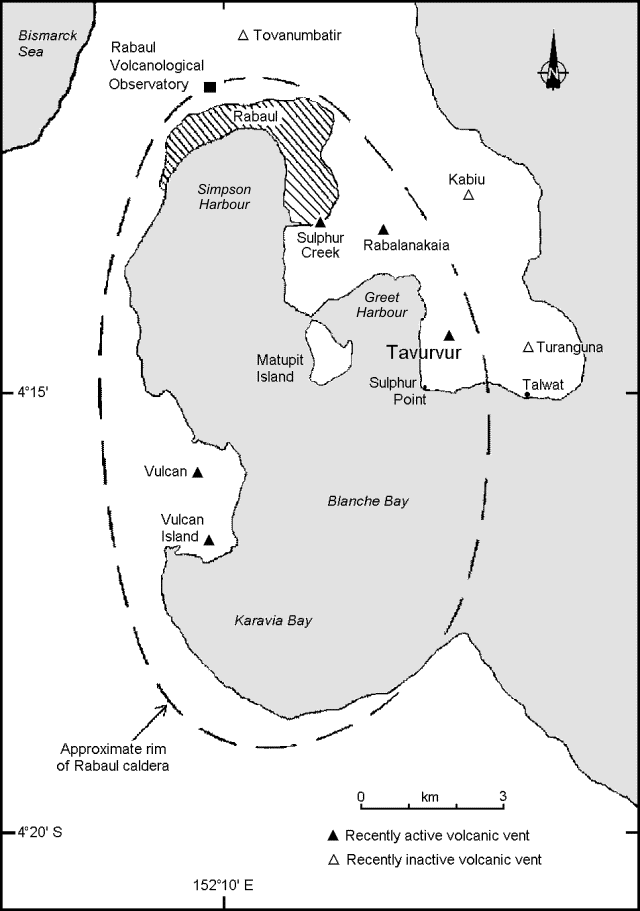 |
Figure 35. Map of Rabaul caldera showing locations of volcanic vents, selected towns, and features (modified from Almond and McKee, 1982). |
For most of May, seismic activity was low. The exception was a ~M 4.8 earthquake that occurred at 1649 on 10 May and was centered 30 km NE of Rabaul. This produced several aftershocks; a total of 95 high-frequency triggered events were recorded on this date. Because of the proximity of these events to the established 'NE earthquake zone,' which is associated with ongoing eruptive activity, there was an expectation that higher levels of summit activity would occur at Tavurvur.
In June, 13 high-frequency events were recorded. Most originated NE of the Rabaul caldera. The S-P interval for these events was 1-4 seconds. Earthquakes occurring in this region have apparently been associated with the ongoing eruptive activity that began on 28 November 1995. A total of 185 low-frequency triggered events were recorded in June. Most of these events were related to explosions during two episodes of ashfall, one on 5 June and the other on 28 June. In addition, quasi-monochromatic volcanic tremor with durations ranging from a few minutes to a few hours were recorded during these periods. An increase in low- frequency non-triggered events was noted before each of the two episodes.
The 5 and 28 June episodes were characterized by moderate ashfall that emanated from Tavurvur. The first episode began on 5 June with a Vulcanian eruption that deposited lithic blocks beyond the crater rim. Through 8 June there was moderate-to-heavy ashfall. On 6 June at 1150 a loud explosion occurred at the 1941 vent. This was followed by increased explosive activity until the afternoon of 7 June when explosions occurred at 30-minute intervals. The explosion clouds contained moderate amounts of ash and rose to about 1.0-1.5 km above the summit. These ash clouds were blown such that they deposited ash towards the N, NE, and NW where Rabaul Town is located. By 8 June, the explosions had subsided to occasional emissions of light-to-moderate white vapor. For the following two weeks, the areas to the N, NE, and NW were continuosly blanketed in a thin fog of white vapor from Tavurvur.
At 0527(?) on 28 June, another explosion from the 1941 vent triggered the second period of light-to-moderate ashfall. The explosion was followed immediately by a dark grey ash cloud that rose to 1.5 km above the summit before being blown to the N and NW. Over the next two days, further ash clouds were produced that attained heights of several hundred meters. Discrete explosions, occurring at long intervals, marked the end of this period of activity. The last explosion occurred on 30 June.
Beginning in early May, electronic and wet-tilt measurements showed a downward tilt with a total deflation of ~9.0 µrad throughout May and June. However, an inflation of 4.0 µrad was recorded before the activity of 5-8 June and 5.5 µrad was recorded before the 27-30 June activity.
The low-lying Rabaul caldera forms a sheltered harbor once utilized by New Britain's largest city Rabaul prior to the 1994 eruption, which forced the abandonment of the city. Tavurvur and Vulcan are two eruption centers within the Rabaul caldera complex. These volcanoes have had virtually simultaneous eruptions in 1878, 1937, and 1994.
Geological Summary. The low-lying Rabaul caldera on the tip of the Gazelle Peninsula at the NE end of New Britain forms a broad sheltered harbor utilized by what was the island's largest city prior to a major eruption in 1994. The outer flanks of the asymmetrical shield volcano are formed by thick pyroclastic-flow deposits. The 8 x 14 km caldera is widely breached on the east, where its floor is flooded by Blanche Bay and was formed about 1,400 years ago. An earlier caldera-forming eruption about 7,100 years ago is thought to have originated from Tavui caldera, offshore to the north. Three small stratovolcanoes lie outside the N and NE caldera rims. Post-caldera eruptions built basaltic-to-dacitic pyroclastic cones on the caldera floor near the NE and W caldera walls. Several of these, including Vulcan cone, which was formed during a large eruption in 1878, have produced major explosive activity during historical time. A powerful explosive eruption in 1994 occurred simultaneously from Vulcan and Tavurvur volcanoes and forced the temporary abandonment of Rabaul city.
Information Contacts: Ima Itikarai, David Lolok, Herman Patia, and Steve Saunders, Rabaul Volcano Observatory (RVO), P.O. Box 386, Rabaul, Papua New Guinea.