Report on Apoyo (Nicaragua) — July 2000
Bulletin of the Global Volcanism Network, vol. 25, no. 7 (July 2000)
Managing Editor: Richard Wunderman.
Apoyo (Nicaragua) Tectonic seismicity between Apoyo and Masaya in July 2000
Please cite this report as:
Global Volcanism Program, 2000. Report on Apoyo (Nicaragua) (Wunderman, R., ed.). Bulletin of the Global Volcanism Network, 25:7. Smithsonian Institution. https://doi.org/10.5479/si.GVP.BGVN200007-344802
Apoyo
Nicaragua
11.92°N, 86.03°W; summit elev. 600 m
All times are local (unless otherwise noted)
[The following was originally included within the Masaya report, not as a stand-alone report about Apoyo.]
July 2000 seismicity near Masaya and Laguna de Apoyo. During July 2000 there were over 300 earthquakes near Laguna de Apoyo (Apoyo volcano) and Masaya. The earthquakes, determined to be of tectonic rather than volcanic origin, caused surficial damage at both volcanoes.
At 1329 on 6 July a small M 2 earthquake occurred near the N rim of Laguna de Apoyo that was followed at 1330 by a M 5.4 earthquake (figure 1). It was located ~32 km SE of Managua, at 11.96°N, 86.02°E, with a focal depth less than 1 km (figure 2). The earthquake was felt in most of Nicaragua and was most strongly felt in the cities of Managua (Modified Mercalli V-VI) and Masaya (VI), and in the region near Laguna de Apoyo (maximum intensity of VII or VIII). The earthquake caused numerous landslides down the volcano's crater walls and surface faulting was observed. In towns located in the epicentral zone, trees and electric lines fell and many houses were partially or totally destroyed. About 70 people were injured and four children were killed by collapsing walls or roofs of homes. At Masaya volcano, ~8 km from the epicenter, there were minor collapses of Santiago crater's walls. No change in degassing was observed at the volcano.
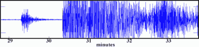 |
Figure 1. Seismogram showing the M 2 and M 5.4 earthquakes near the Masaya volcano station on 6 July 2000. Courtesy of INETER. |
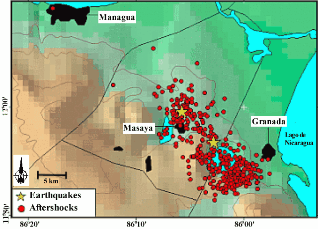 |
Figure 2. Epicenters near Masaya for the M 5.4 earthquake on 6 July, and the M 4.8 earthquake on 25 July 2000 (stars). The aftershocks from these earthquakes are also shown (small circles). Courtesy of INETER. |
Immediately after the earthquake there were many smaller, shallow earthquakes in a zone that includes the area between Masaya, Laguna de Apoyo, and W of Granada (figure 2). In the epicentral zone property was destroyed, cracks opened in the ground, landslides occurred, and trees fell. Several landslides occurred at the edges and steep walls of Laguna de Apoyo. A large number of earthquakes continued until 10 July (figure 3 and table 1). The number of earthquakes then diminished until 1554 on 25 July when a M 4.8 earthquake took place, initiating a series of smaller earthquakes that lasted until about 27 July.
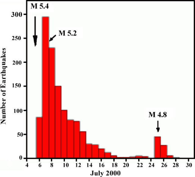 |
Figure 3. Graph showing the number of earthquakes in the Masaya region between 4 and 30 July 2000. Courtesy of INETER. |
Table 1. A summary of earthquakes in vicinity of Masaya and Laguna de Apoyo in early July 2000. Courtesy of INETER.
| Date | Time | Number of daily earthquakes | Maximum magnitude |
| 07 Jul 2000 | 1330 | 180 | 5.2 |
| 08 Jul 2000 | 1100 | 70 | 3.8 |
| 09 Jul 2000 | 1200 | 81 | 3.6 |
| 10 Jul 2000 | 1800 | 27 | 3.1 |
| 11 Jul 2000 | 1800 | 6 | 3.3 |
| 13 Jul 2000 | 1800 | 16 | 2.8 |
The July earthquakes were the most destructive seismic events since the 1972 Managua earthquake. The epicentral zone of the July 2000 earthquakes correlates with the same active zones of past earthquakes, which are caused by fault movement between the Cocos and Caribbean plates.
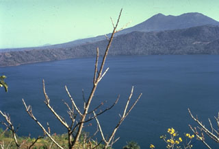
Geological Summary. The scenic 7-km-wide, lake-filled Apoyo caldera is a large silicic volcanic center immediately SE of Masaya caldera. The surface of Laguna de Apoyo lies only 78 m above sea level; the steep caldera walls rise about 100 m to the eastern rim and up to 500 m to the western rim. An early shield volcano constructed of basaltic-to-andesitic lava flows and small rhyodacitic lava domes collapsed following two major dacitic explosive eruptions. The caldera-forming eruptions have been radiocarbon dated between about 21,000-25,000 years before present. Post-caldera ring-fracture eruptions of uncertain age produced lava flows below the scalloped caldera rim. The slightly arcuate, N-S-trending La Joya fracture system that cuts the eastern flank of the caldera only 2 km east of the caldera rim is a younger regional fissure system structurally unrelated to Apoyo caldera.
Information Contacts: Wilfried Strauch and Virginia Tenorio, Dirección General de Geofísica, Instituto Nicaragüense de Estudios Territoriales (INETER), Apartado 1761, Managua, Nicaragua (URL: http://www.ineter.gob.ni/).