Report on El Chichon (Mexico) — September 2000
Bulletin of the Global Volcanism Network, vol. 25, no. 9 (September 2000)
Managing Editor: Richard Wunderman.
El Chichon (Mexico) Warming and solute concentration rises detected during December 1999 visit
Please cite this report as:
Global Volcanism Program, 2000. Report on El Chichon (Mexico) (Wunderman, R., ed.). Bulletin of the Global Volcanism Network, 25:9. Smithsonian Institution. https://doi.org/10.5479/si.GVP.BGVN200009-341120
El Chichon
Mexico
17.3602°N, 93.2297°W; summit elev. 1150 m
All times are local (unless otherwise noted)
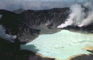
Since the eruptions of 1982, observations at El Chichón have indicated decreasing magmatic fluids. However, sampling in December 1999 revealed that this is no longer the case. On 24 April 2000, water in El Chichón's crater lake had a temperature of 47°C. Previous temperatures had not exceeded 38°C since January 1983 when the lake reached 56°C. Boron concentrations, at 66 mg/L, were also the highest recorded values since January 1983. SiO2 values were 357 mg/L; this is the highest concentration since August of 1992. Sulfide, which had not been present in samples since 1993, was at 3.22 mg/L, the highest concentration ever recorded. At the time of the 24 April sampling, the crater lake covered approximately half of the bottom of the crater. This apparent increase in the level of the crater lake was the only significant change in El Chichón's morphology.
Further Reference. Armienta M.A., De la Cruz-Reyna S., and Macías, J.L., 2000, Chemical characteristics of the crater lakes of Popocatepetl, El Chichón, and Nevado de Toluca volcanoes, Mexico: JVGR 97, p. 105-125.
Geological Summary. El Chichón is a small trachyandesitic tuff cone and lava dome complex in an isolated part of the Chiapas region in SE México. Prior to 1982, this relatively unknown volcano was heavily forested and of no greater height than adjacent non-volcanic peaks. The largest dome, the former summit of the volcano, was constructed within a 1.6 x 2 km summit crater created about 220,000 years ago. Two other large craters are located on the SW and SE flanks; a lava dome fills the SW crater, and an older dome is located on the NW flank. More than ten large explosive eruptions have occurred since the mid-Holocene. The powerful 1982 explosive eruptions of high-sulfur, anhydrite-bearing magma destroyed the summit lava dome and were accompanied by pyroclastic flows and surges that devastated an area extending about 8 km around the volcano. The eruptions created a new 1-km-wide, 300-m-deep crater that now contains an acidic crater lake.
Information Contacts: Silvia Ramos, Monitoreo Volcanológioc y Sismológico, Chiapas, México, Río Cantela 221, Fracc Paraíso II, Tuxtla Gutierrez, Chiapas, México; M. Aurora Armienta, Instituto de Geofisica, UNAM, México 04510, D.F., México.