Report on Karthala (Comoros) — October 2000

Bulletin of the Global Volcanism Network, vol. 25, no. 10 (October 2000)
Managing Editor: Richard Wunderman.
Karthala (Comoros) Increased seismicity during July-September; dramatic increase in October
Please cite this report as:
Global Volcanism Program, 2000. Report on Karthala (Comoros) (Wunderman, R., ed.). Bulletin of the Global Volcanism Network, 25:10. Smithsonian Institution. https://doi.org/10.5479/si.GVP.BGVN200010-233010
Karthala
Comoros
11.75°S, 43.38°E; summit elev. 2361 m
All times are local (unless otherwise noted)
During July, August, and September 2000, seismic activity at Karthala increased from a background level of less than 10 events/month to almost 40 events/month (figure 5). This increase accelerated at the beginning of October, gradually reaching 20 events/day by 15 October. The seismicity, characterized by events located at shallow depths (2-3 km) under the summit caldera, continued at the same rate through the beginning of November. These events were generally minor. However, more significant seismicity was recorded during the night of 22-23 October. This seismic activity showed significant daily variations; a swarm of 17 earthquakes was recorded on 30 October within a period of 15 minutes. Observations by A. Lemarchand (Karthala Volcanological Observatory) allowed the documentation of a very clear increase in the level of the lake that formed in the Chougou Chahalé crater since the July 1991 phreatic eruption.
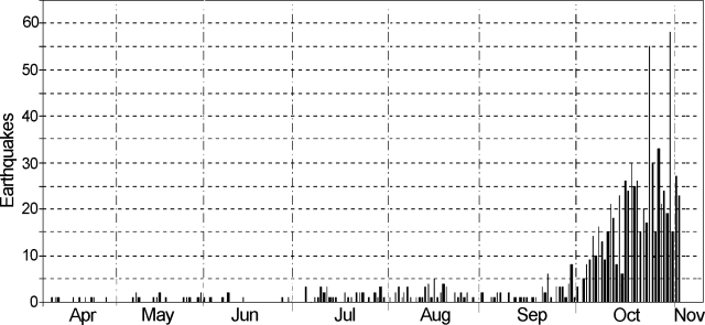 |
Figure 5. Earthquakes at Karthala (Grande Comore, Comoros Islands) during 1 April-2 November 2000. Data provided courtesy of A. Lemarchand, Karthala Volcano Observatory. |
Reuters reported that the inhabitants of Grande Comore, the main island of the Comoros group, were warned on 29 October 2000 that their island's volcano could soon erupt. In messages read on state radio, the Comoros government warned islanders to be vigilant and to avoid the area around the volcano.
Geological Summary. The southernmost and largest of the two shield volcanoes forming Grand Comore Island (also known as Ngazidja Island), Karthala contains a 3 x 4 km summit caldera generated by repeated collapse. Elongated rift zones extend to the NNW and SE from the summit of the Hawaiian-style basaltic shield, which has an asymmetrical profile that is steeper to the S. The lower SE rift zone forms the Massif du Badjini, a peninsula at the SE tip of the island. Historical eruptions have modified the morphology of the compound, irregular summit caldera. More than twenty eruptions have been recorded since the 19th century from the summit caldera and vents on the N and S flanks. Many lava flows have reached the sea on both sides of the island. An 1860 lava flow from the summit caldera traveled ~13 km to the NW, reaching the W coast to the N of the capital city of Moroni.
Information Contacts: A. Lemarchand, Observatoire Volcanologique du Karthala, Centre National de Documentation et de la Recherche Scientifique des Comores (CNDRS), BP 169, Moroni, République Fédérale Islamique des Comores (URL: http://volcano.ipgp.jussieu.fr/karthala/stationkar.html); P. Bachélery, Département des Sciences de la Terre, Université de la Réunion, BP 7151, 15 Avenue Rene Cassin, 97715 Saint Denis Cedex 9, La Réunion, France; Reuters news service.