Report on Bezymianny (Russia) — October 2000
Bulletin of the Global Volcanism Network, vol. 25, no. 10 (October 2000)
Managing Editor: Richard Wunderman.
Bezymianny (Russia) Large ash explosions in late October; hazard status reaches orange
Please cite this report as:
Global Volcanism Program, 2000. Report on Bezymianny (Russia) (Wunderman, R., ed.). Bulletin of the Global Volcanism Network, 25:10. Smithsonian Institution. https://doi.org/10.5479/si.GVP.BGVN200010-300250
Bezymianny
Russia
55.972°N, 160.595°E; summit elev. 2882 m
All times are local (unless otherwise noted)
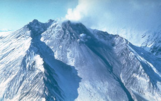
A 4-pixel thermal anomaly, initially detected in satellite images by the Alaska Volcano Observatory (AVO) on 21 September (BGVN 25:09), continued to be observed on 20 October. Each pixel in the center of an AVHRR satellite image is a 1.1-km square, but the pixel dimensions are significantly larger toward the image edge. In the case at hand, the pixel locations within the image were toward the edge, and could have a maximum dimension of 2.3 km x 5.5 km. On 21 October, a fumarolic plume rose 50 m above the volcano and extended E. On 25 October, a fumarolic plume rose to a height of 50 m and drifted 20 km S. Since then, seismic data indicated that hot rock avalanches may have descended from Bezymianny's dome. A few small shallow earthquakes per day occurred beneath the volcano during 20-26 October. Spasmodic seismic tremor was registered during 2040-2100 on 26 October, but was difficult to analyze because of a malfunctioning seismic station. The volcano's hazard status remained at Yellow.
Energy from B-type earthquakes increased beginning at 0115 on 28 October. The thermal anomaly grew to 8 pixels in size with 4 pixels at a saturation temperature of 50°C according to satellite imagery at 0632 on 30 October, and the hazard status was increased to Orange. At 0810 a gas-and-steam plume rose 1,000 m above the volcano and extended NE. Seismic activity increased after 2300 with the most intense seismicity recorded on 31 October during 0146-0215. A distinct explosive event, however, was not detected in the seismic data. AVHRR satellite data from an image at 0600 on 31 October showed an ash plume extending ~80 km SE. It was not possible to estimate the height of the plume. According to a visual report from Koziyrevsk at 0730 on 31 October, a gas-and-steam plume rose 1.5 km above the summit and extended to the SE. At 1210 an ash-poor plume rose 3 km above the volcano. A gas-and-steam plume rose 1 km at 1330, and another plume reached 2 km at 1515.
An image from 1506 on 31 October showed an ash-poor plume extending ~40 km NE of Bezymianny. A larger diffuse cloud was seen off the east coast of Kamchatka and seemed to be continuous with the more distinct plume emanating from the volcano. It extended ~250 km SE, but did not appear to contain an ash component. Intense seismicity was registered during 0320-0400 and at 0626 on 2 November. A satellite image from 0626 showed an ash plume with an estimated altitude of ~3,600 m that extended 50 km W, then 130 km SW of the volcano. A visual report from Koziyrevsk at 0800 indicated that a gas-and-steam plume rose 1 km above the summit and extended SW. At 0842, a gas-and-ash plume reached 1.5 km above the volcano and also extended SW. Seismicity began to decrease beginning at 1200. A satellite image from 1650 revealed a 250-km-long ash plume that drifted ~300 km SW of Bezymianny, centered over the lower third of the Kamchatkan Peninsula. An image from 0618 on 3 November showed that by then the plume reached only ~30 km SW. According to a Koziyrevsk visual report at 1355, a gas-and-steam plume rose 1 km above the volcano. Volcanic ash advisory statements were issued to aviators during 2-3 November, and indicated that aircraft needed to ascend above 6,000 m altitude or divert around the ash plume. Satellite imagery indicated that the ash cloud was moving at up to 37 km/hour SW to WSW. The hazard status for Bezymianny decreased from Orange to Yellow as of 3 November.
Seismicity decreased to background levels by the week of 3-9 November. From 3-6 November, a gas-and-steam plume rose 1-2 km above the summit and extended 20-60 km to the SE. A gas-and-steam plume rose 500 m on 7 November. The hazard status for the volcano was decreased from Yellow to Green on 10 November. AVHRR satellite data from AVO at 0634 on 12 November showed that the thermal anomaly was now only one pixel in size. A gas-and-steam plume rose 100 m above the volcano and extended SE on 16 November. The hazard status for Bezymianny remained at Green on 17 November.
Geological Summary. The modern Bezymianny, much smaller than its massive neighbors Kamen and Kliuchevskoi on the Kamchatka Peninsula, was formed about 4,700 years ago over a late-Pleistocene lava-dome complex and an edifice built about 11,000-7,000 years ago. Three periods of intensified activity have occurred during the past 3,000 years. The latest period, which was preceded by a 1,000-year quiescence, began with the dramatic 1955-56 eruption. This eruption, similar to that of St. Helens in 1980, produced a large open crater that was formed by collapse of the summit and an associated lateral blast. Subsequent episodic but ongoing lava-dome growth, accompanied by intermittent explosive activity and pyroclastic flows, has largely filled the 1956 crater.
Information Contacts: Olga Chubarova, Kamchatka Volcanic Eruptions Response Team (KVERT), Institute of Volcanic Geology and Geochemistry, Piip Ave. 9, Petropavlovsk-Kamchatsky, 683006, Russia; Tom Miller, Alaska Volcano Observatory (AVO), a cooperative program of a) U.S. Geological Survey, 4200 University Drive, Anchorage, AK 99508-4667, USA (URL: http://www.avo.alaska.edu/), b) Geophysical Institute, University of Alaska, PO Box 757320, Fairbanks, AK 99775-7320, USA, and c) Alaska Division of Geological & Geophysical Surveys, 794 University Ave., Suite 200, Fairbanks, AK 99709, USA; Tokyo VAAC, Tokyo, Japan (URL: https://ds.data.jma.go.jp/svd/vaac/data/).