Report on Piton de la Fournaise (France) — December 2000

Bulletin of the Global Volcanism Network, vol. 25, no. 12 (December 2000)
Managing Editor: Richard Wunderman.
Piton de la Fournaise (France) 12 October-13 November eruption near July eruption site
Please cite this report as:
Global Volcanism Program, 2000. Report on Piton de la Fournaise (France) (Wunderman, R., ed.). Bulletin of the Global Volcanism Network, 25:12. Smithsonian Institution. https://doi.org/10.5479/si.GVP.BGVN200012-233020
Piton de la Fournaise
France
21.244°S, 55.708°E; summit elev. 2632 m
All times are local (unless otherwise noted)
Piton de la Fournaise erupted several times during 2000; 14 February to 4 March (BGVN 25:01), 23 June to 30 July (BGVN 25:07), and in October. The last eruption in 2000 began on 12 October after two periods of inflation, high pre-eruptive radon emissions, and three weeks of increased seismicity beneath the volcano.
During the two months prior to the eruption, two tiltmeter stations, "Dolomieu Sud," located at the volcano's summit and "Château Fort" on its southern base, showed tilt variations of up to 50 µrad, which indicated a clear inflation of the S flank. In addition, extensometer data at Château Fort showed that fissure openings had significantly increased since the preceding eruption in June 2000. The fissure expansions confirmed that inflation was occurring.
Three weeks prior to the eruption high seismicity occurred under the volcano, with 10 to 20 earthquakes per day. A small seismic crises that consisted of 57 earthquakes occurred on 6 October (figure 56). Thereafter, the number of seismic events returned to the high levels that had been recorded during the previous 3 weeks until the number of earthquakes significantly increased on 12 October, marking the beginning of the eruption. All of the 278 seismic events that occurred between the end of September and 12 October were of very low energy, usually with magnitudes less than 0.7. Only seven earthquakes were recorded with higher magnitudes, ranging between 0.9 and 1.7.
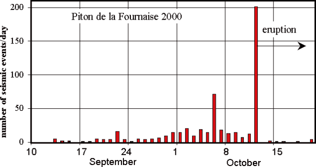 |
Figure 56. The number of daily seismic events recorded at seismic stations at Piton de la Fournaise during 10 September through 21 October 2000. Courtesy of OVPDLF. |
In addition to increased seismicity, high radon activity was measured at the volcano. Three different probes in soil and old eruption vents at the "Bory" station on the W rim of the summit crater showed a high mean level of radon activity. The "Bory 3" radon probe showed about 40 counts per day, which was 2.7 times higher than during January-May 2000. OVPDLF scientists determined that the high counting rates indicated a general increase in volcanic gas emissions from the volcano, reflecting the presence of degassing magma.
At 0401 on 12 October a seismic crisis began that consisted of 201 low-energy events (figure 56). All but five events had magnitudes less than or equal to 1.1, with the largest being 1.6. The seismic crisis lasted 64 minutes and at 0505 a strong eruption tremor, which was localized on the E flank of the volcano, appeared at the summit stations. Visual observations helped to constrain the eruption site between "Signal de l'Enclos" and "Le Langlois" craters, and above "Piton Pârvédi" crater, which formed during the previous eruption in June 2000 (figure 57). Field observations conducted with a hand-held GPS receiver allowed scientists to precisely locate the two fissures where lava was emitted during the eruption. The smaller fissure (fissure 1) was several tens of meters long, located at 2,260 m in altitude, and emitted a small, 50-100 m long aa lava flow. The other fissure (fissure 2) was 680 m long and ran continuously between 2,220 m and 2,000 m in altitude.
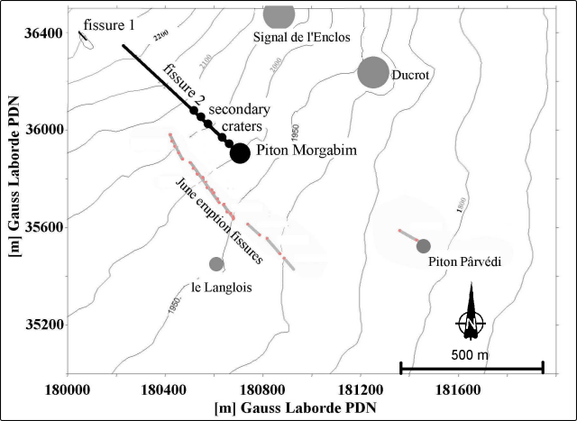 |
Figure 57. Sketch map showing the location of craters of the 12 October activity and fissures where lava flows were emitted. PDN (Piton de Neiges) is a coordinate system used on Reunion Island by IGN and other scientists. In general, IGN maps include both PDN and international ellipsoid coordinates. Courtesy of OVPDLF. |
Almost all of the lava-flow activity occurred at fissure 2. At 1100 on 12 October, lava fountaining still occurred within the lower 350 m of fissure 2, and lava output was relatively high. A large network of numerous aa lava flows of up to 200 m width traveled down the SE flank of the volcano towards "Piton Pârvédi" and continued in a single, large lava flow for 5.5 km on the southern border of the June lava flow until reaching 400 m in altitude. At 2100 on 13 October, about 40 hours after the eruption began, the rate of lava emission was still high with an estimated rate of 40-60 m3/s. A continuous incandescent lava flow, at least 2 km long, was visible.
The following day volcanic activity was focused on the lower end of fissure 2, and a crater began to build up. It was named "Piton Morgabim." Initially the crater was U-shaped with an opening towards the ESE. Throughout the entire period of activity a permanent lava lake was present within the crater, and lava flows were observed on the downhill (SE) side of the crater. During the first week of November the crater closed so that the lava lake was no longer visible, and the upper crater walls were high and sub-vertical. Several tunnels began to form and a tumulus that was several tens of meters high piled up in front of "Piton Morgabim" (figure 58). Since the end of October pahoehoe lava flows appeared in the upper part of the initial aa lava flows and surrounded "Piton Pârvédi" crater to the N and S.
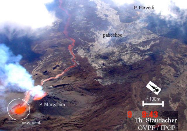 |
Figure 58. Photograph of the eruption, taken from the SW at 0943 on 9 November from a helicopter. The photograph shows the initial crater ("Piton Morgabim") and the new vent (circled to the left) and an active incandescent lava flow channel. The pahoehoe lava flows above "Piton Pârvédi" that began in late October can be distinguished (gray area), as well as the tumulus in front of "Piton Morgabim." Courtesy of OVPDLF. |
Since 29 October, tremor began to increase until it reached the same high value as during the first minutes of the eruption. Tremor remained at high levels for the following 5 days. Beginning on 5 November strong degassing and liberation of H2S occurred just above "Piton Morgabim." On 8 November the upper crater walls collapsed and the [lava] lake, which was ~40 m in diameter, was visible again. On 9 November an intense explosion occurred ~50 m NW of "Piton Morgabim" crater, and rocks and lava were ejected up to 200 m in altitude. A second vent formed in this area and both it and "Piton Morgabim" were simultaneously active for several tens of hours (figure 58 and 59). From 12 November, explosions and black ash were observed at the upper vent, which were most likely phreatomagmatic features. Lava bombs were ejected up to 250 m away from the vent. Both vents fused together, and the initial crater raised up, finally forming one single large crater named "Piton Morgabim" (figure 59). Figures 16 and 17 show different stages of the vents growing together. During the period of increased tremor, new several-km-long pahoehoe flows formed. Again they surrounded Piton Pârvédi to the N and S and covered large parts of the June 2000 lava flow. In particular, one pahoehoe lava flow extended beyond the front of the June eruption in the "Grand Brûlé" by ~500 m length down to 370 m elevation.
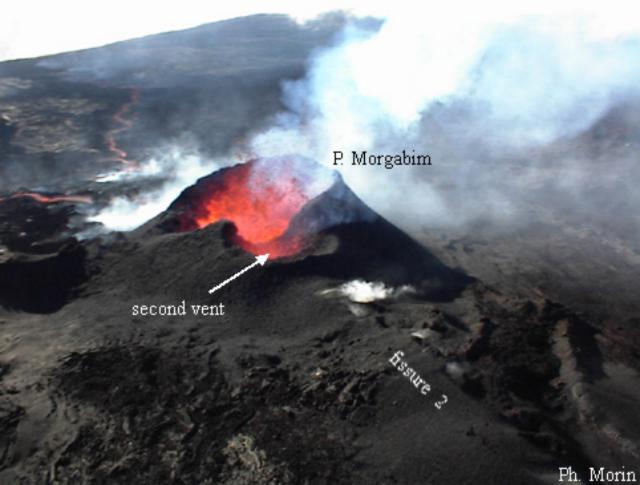 |
Figure 59. Photograph of "Piton Morgabim" and a second crater coalescing at Piton de la Fournaise. The photograph was taken on 11 November from the E flank of the volcano. The saddle-shaped separation between the two craters disappeared during the next days. Bright spots to the left and right of the craters were emanations from the lava flow and fissure 2, respectively. Courtesy of P. Morin. |
The high level of tremor suddenly disappeared at 2310 on 13 November, marking the end of the eruption. By this time the remaining crater, "Piton Morgabim," was ~100 x 75 m across and 30-40 m deep (figure 60). On 15 November, the lava flow SE of the crater was still hot; a temperature of ~800°C was measured 40 cm below the surface.
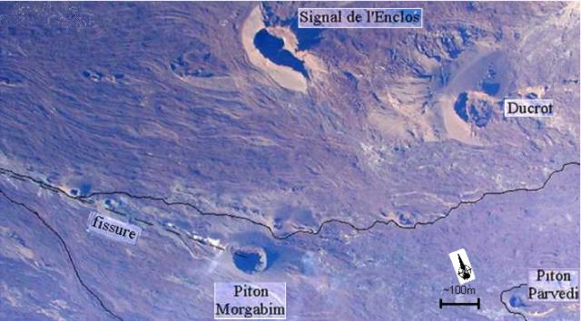 |
Figure 60. Photograph of the surface of the affected area of Piton de la Fournaise after the eruption. The black line shows the outline of the lava flow. Courtesy of OVPDLF. |
Basalt samples were collected throughout the eruption. The initial basalt was apheric, near the end of October olivine crystals appeared, and near the end of the eruption the basalt had numerous centimeter-sized olivine crystals.
Digital photos were analyzed in order to map the lava flow and to obtain an estimate of it's erupted volume. The total erupted volume was estimated to be on the order of 5 x 10⁶ m3, which is a typical value for eruptions at Piton de la Fournaise.
Correction. In BGVN 25:07 the area of the entire lava flow from the 23 June-30 July 2000 eruption of Piton de la Fournaise was reported as being 3 x 10² m2, when it was actually 3 x 10⁶ m2.
Geological Summary. Piton de la Fournaise is a massive basaltic shield volcano on the French island of Réunion in the western Indian Ocean. Much of its more than 530,000-year history overlapped with eruptions of the deeply dissected Piton des Neiges shield volcano to the NW. Three scarps formed at about 250,000, 65,000, and less than 5,000 years ago by progressive eastward slumping, leaving caldera-sized embayments open to the E and SE. Numerous pyroclastic cones are present on the floor of the scarps and their outer flanks. Most recorded eruptions have originated from the summit and flanks of Dolomieu, a 400-m-high lava shield that has grown within the youngest scarp, which is about 9 km wide and about 13 km from the western wall to the ocean on the E side. More than 150 eruptions, most of which have produced fluid basaltic lava flows, have occurred since the 17th century. Only six eruptions, in 1708, 1774, 1776, 1800, 1977, and 1986, have originated from fissures outside the scarps.
Information Contacts: Thomas Staudacher, Jean Louis Cheminée, Observatoire Volcanologique du Piton de la Fournaise, Institut de Physique du Globe de Paris, Institut National des Sciences de l'Univers, 14 RN3 - Km 27, 97418 La Plaine des Cafres, Réunion, France (URL: http://www.ipgp.fr/fr/ovpf/observatoire-volcanologique-piton-de-fournaise).