Report on Ambae (Vanuatu) — January 2001
Bulletin of the Global Volcanism Network, vol. 26, no. 1 (January 2001)
Managing Editor: Richard Wunderman.
Ambae (Vanuatu) Sustained elevation of Lake Voui's temperature indicates increased heat transfer
Please cite this report as:
Global Volcanism Program, 2001. Report on Ambae (Vanuatu) (Wunderman, R., ed.). Bulletin of the Global Volcanism Network, 26:1. Smithsonian Institution. https://doi.org/10.5479/si.GVP.BGVN200101-257030
Ambae
Vanuatu
15.389°S, 167.835°E; summit elev. 1496 m
All times are local (unless otherwise noted)
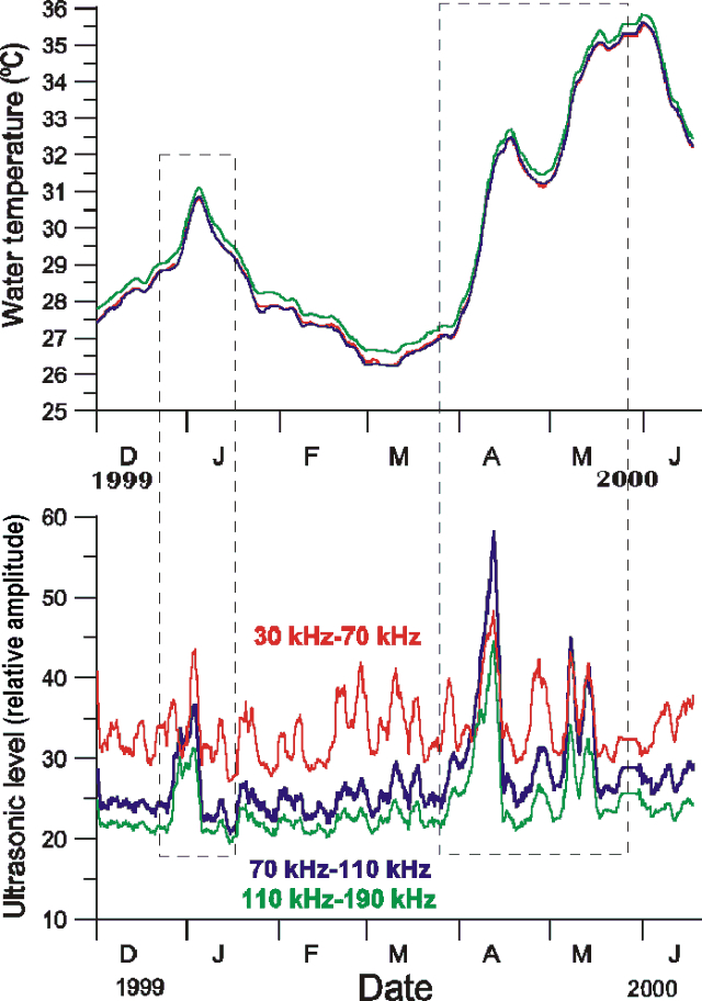
Voui crater lake's temperature and hydro-acoustic signals are measured continuously by an automated station that transmits in real time via satellite (BGVN 23:10). Recent measurements revealed heavy activity under the lake during March-June 2000 (BGVN 25:08), when the estimated 50 x 106 m3 volume of water rapidly increased in temperature by more than 7°C (figure 10).
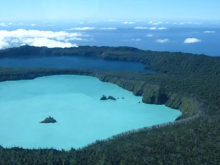
The increase was accompanied by acoustic signals covering a wide range of frequencies (figure 10, bottom). Those in the audible band (> 100 Hz) were thought to be associated with the emission of gas bubbles and an increase in submarine fumarolic activity. Those in the ultrasound band (30-190 kHz) could stem from fluids circulating within the hydrothermal zone beneath the lake (figure 11).
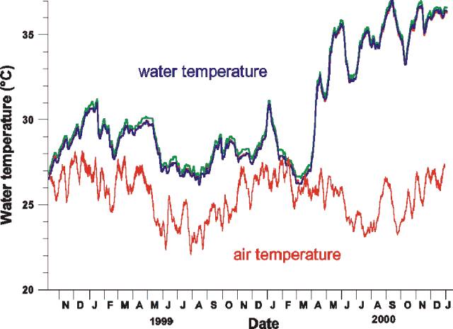
A consistent first-order rise in water temperatures persisted through December 2000 (figure 12). Despite seasonal variations in air temperature and the cooling effect of heavy tropical rainfall (~5 m/yr), Lake Voui's temperature remained stable at ~36°C as of January 2001. The preceding rise and sustained high temperature indicate continued heat transfer from the bottom of the lake. The effect appears more substantial than the heating seen between 1996 and 1999, when water temperature averaged ~30°C.
 |
Figure 12. Aoba's Lake Voui air and water temperatures during October 1998-January 2001. Courtesy of Michel Lardy. |
Geological Summary. The island of Ambae, also known as Aoba, is a massive 2,500 km3 basaltic shield that is the most voluminous volcano of the New Hebrides archipelago. A pronounced NE-SW-trending rift zone with numerous scoria cones gives the 16 x 38 km island an elongated form. A broad pyroclastic cone containing three crater lakes (Manaro Ngoru, Voui, and Manaro Lakua) is located at the summit within the youngest of at least two nested calderas, the largest of which is 6 km in diameter. That large central edifice is also called Manaro Voui or Lombenben volcano. Post-caldera explosive eruptions formed the summit craters about 360 years ago. A tuff cone was constructed within Lake Voui (or Vui) about 60 years later. The latest known flank eruption, about 300 years ago, destroyed the population of the Nduindui area near the western coast.
Information Contacts: Michel Lardy, Institut de Recherche pour le Développement (IRD), Centre d"Ile de France 93143 Bondy Cédex, France; Michel Halbwachs, Université de Savoie, BP1104, F 73376 Le Bourget du Lac Cédex, France; Jeanne Tabbagh, Université Pierre et Marie Curie, Départment de géophysique appliquée, 75252 Paris Cédex O5, France; Douglas Charley, Department of Geology, Mines, and Water Resources, PMB01, Port-Vila, Vanuatu, Oceania.


