Report on McDonald Islands (Australia) — February 2001
Bulletin of the Global Volcanism Network, vol. 26, no. 2 (February 2001)
Managing Editor: Richard Wunderman.
McDonald Islands (Australia) Emission of volatiles on 9 November 2000; morphological changes
Please cite this report as:
Global Volcanism Program, 2001. Report on McDonald Islands (Australia) (Wunderman, R., ed.). Bulletin of the Global Volcanism Network, 26:2. Smithsonian Institution. https://doi.org/10.5479/si.GVP.BGVN200102-234011
McDonald Islands
Australia
53.03°S, 72.6°E; summit elev. 230 m
All times are local (unless otherwise noted)
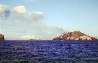
Observations of McDonald Island were made from aboard the vessel "RSV Aurora Australis" on 9 November 2000. These were the first documented observations of the volcano in several months. Atmospheric conditions were overcast but afforded good lateral visibility. Venting of volatiles was first sighted at a distance of 24 km from the island. Subsequent observations were made as close as 7 km offshore. Dispersed activity was visible at several points high on the flanks of the island. On the NE side, fumarolic activity was most pronounced at the top of a short steep gully extending below the apparent summit crater. Pulses of emission produced plumes 30-50 m high from this point every few minutes. Volatiles were also being emitted from several other points on the NW slopes, and at the N end of the island where they originated at the foot of rock bluffs near the top of the coastal slope and at another location on the slope at ~60 m elevation. There was no evidence of activity on the S portion of the island.
The emissions observed during November 2000 were less pronounced than those described on 13 January 1999 (BGVN 24:01). They also appear to have been issuing from higher on the slopes than those observed on 18 March and 2 April 1997 (BGVN 23:02). The position of the most forceful emissions observed during November 2000 appeared identical to those first seen in March 1997. Significant emissions from the face below the crater at ~70 m elevation, and from two points at the head of an apron of dark-colored rubble a few hundred meters N of the gully extending from the summit crater, were also similar to those of 1997. Weak discharges that rose from the N edge of the apron were detectable to ~80 m elevation during November 2000, but were absent during March 1997. No steaming ground was observed below ~60-70 m elevation during November 2000, nor was there any evidence of fumarolic activity at sea level as had been cited during March 1997.
Comparisons of color vertical air photographs taken in 1980 from 3,050 m, 1,650 m, and 980 m altitudes to oblique photographs taken from sea level aboard the "RSV Aurora Australis" on 18 March 1997 and 9 November 2000 (figure 5) indicate that the most significant changes to the morphology of the volcano occurred prior to the vessel's first visit. Some steep coastal slopes appeared to have been replaced by slopes of more moderate angle. A more jagged skyline of bare rock has replaced the relatively smooth, vegetated upper slopes that previously existed.
 |
Figure 5. General view of the NE coast of McDonald Island under hazy conditions on 9 November 2000. Photo by Graeme Snow (AAD), courtesy of Kevin Kiernan. |
Geological Summary. Historical eruptions have greatly modified the morphology of the McDonald Islands, located on the Kerguelen Plateau about 75 km W of Heard Island. The largest island, McDonald, is composed of a layered phonolitic tuff plateau cut by phonolitic dikes and lava domes. A possible nearby active submarine center was inferred from phonolitic pumice that washed up on Heard Island in 1992. Volcanic plumes were observed in December 1996 and January 1997 from McDonald Island. During March 1997 the crew of a vessel that sailed near the island noted vigorous steaming from a vent on the N side of the island along with possible pyroclastic deposits and lava flows. A satellite image taken in November 2001 showed the island to have more than doubled in area since previous reported observations in November 2000. The high point of the island group had shifted to the McDonald's N end, which had merged with Flat Island.
Information Contacts: Suzanne Stallman, Gordon Bain, and Graeme Snow, Australian Antarctic Division (AAD), Channel Highway, Kingston, TAS 7050, Australia (URL: http://www.antarctica.gov.au/); Kevin Kiernan and Anne McConnell, Geography & Environmental Studies, University of Tasmania, GPO Box 252-79, Hobart TAS 7001, Australia.