Report on Fujisan (Japan) — February 2001
Bulletin of the Global Volcanism Network, vol. 26, no. 2 (February 2001)
Managing Editor: Richard Wunderman.
Fujisan (Japan) September 2000-January 2001 swarm includes less than or equal to M 2.2 earthquakes but lacks geodetic changes
Please cite this report as:
Global Volcanism Program, 2001. Report on Fujisan (Japan) (Wunderman, R., ed.). Bulletin of the Global Volcanism Network, 26:2. Smithsonian Institution. https://doi.org/10.5479/si.GVP.BGVN200102-283030
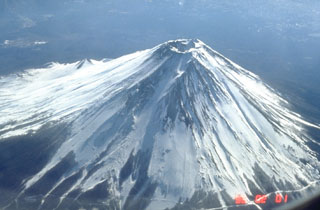
Fujisan
Japan
35.361°N, 138.728°E; summit elev. 3776 m
All times are local (unless otherwise noted)
According to the Japan Meteorological Agency (JMA), a relatively large number of low-frequency, low-magnitude earthquakes have occurred at ~15 km depth below Fuji volcano since September 2000 (table 2, figure 1). For comparison, during recent years before this spike, the number of earthquakes had averaged only 1-2 per month. The maximum earthquake magnitude during September 2000-January 2001 was M 2.2, recorded on 11 October. During November-December earthquakes with M > 2.0 occurred 7 times. Earthquake hypocenters were generally located below an area NE of the summit. Geodetic parameters measured by GPS, EDM, and tilt-meters did not escalate. Located 150 km W of Tokyo, Fuji's close proximity encouraged the installation of enhanced instrumentation in order to better monitor the volcano. Previous seismic swarms at Fuji in 1987 and 1996 (SEAN 12:08 and BGVN 21:02) had lower event counts than the current episode.
Table 2. Seismic events registered at Fuji during September 2000-January 2001. Data courtesy of JMA and Reuters.
| Month | Seismic Events |
| Sep 2000 | 35 |
| Oct 2000 | 133 |
| Nov 2000 | 222 |
| Dec 2000 | 144 |
| Jan 2001 | 36 |
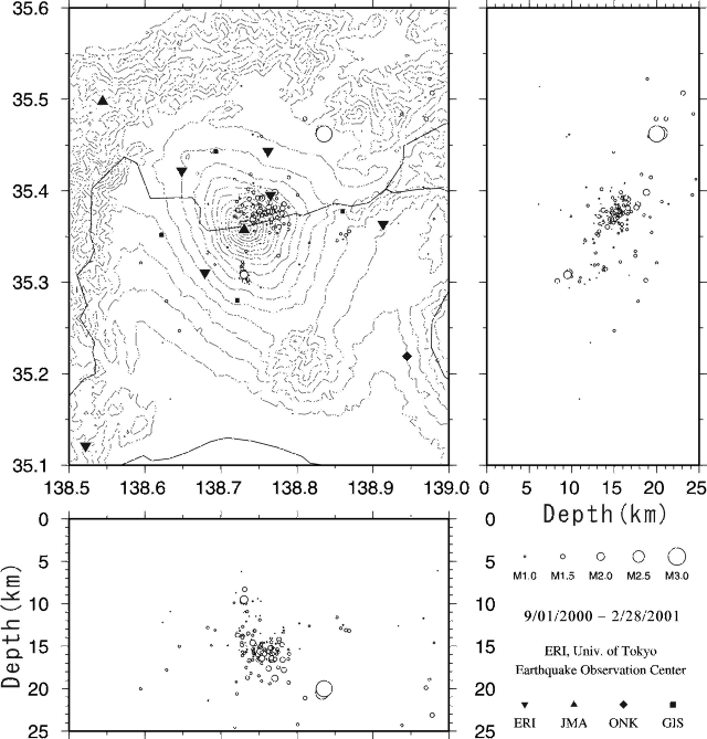 |
Figure 1. Latitude, longitude, depth, and magnitude of seismicity at Fuji during September 2000-February 2001. Earthquake cross-sections are shown in N-S (upper right) and E-W (bottom) planes. Figure by Shin-ichi Sakai; courtesy of Setsuya Nakada (VRC-ERI). |
Geological Summary. The conical form of Fujisan, Japan's highest and most noted volcano, belies its complex origin. The modern postglacial stratovolcano is constructed above a group of overlapping volcanoes, remnants of which form irregularities on Fuji's profile. Growth of the Younger Fuji volcano began with a period of voluminous lava flows from 11,000 to 8000 years before present (BP), accounting for four-fifths of the volume of the Younger Fuji volcano. Minor explosive eruptions dominated activity from 8000 to 4500 BP, with another period of major lava flows occurring from 4500 to 3000 BP. Subsequently, intermittent major explosive eruptions occurred, with subordinate lava flows and small pyroclastic flows. Summit eruptions dominated from 3000 to 2000 BP, after which flank vents were active. The extensive basaltic lava flows from the summit and some of the more than 100 flank cones and vents blocked drainages against the Tertiary Misaka Mountains on the north side of the volcano, forming the Fuji Five Lakes, popular resort destinations. The last confirmed eruption of this dominantly basaltic volcano in 1707 was Fuji's largest during historical time. It deposited ash on Edo (Tokyo) and formed a large new crater on the east flank.
Information Contacts: National Research Institute for Earth Science and Disaster Prevention, 3-1, Tennodai, Tsukuba-shi, Ibaraki-ken, 305, Japan (URL: http://www.bosai.go.jp/); Setsuya Nakada, Hidefumi Watanabe, and Shin-ichi Sakai, Volcano Research Center, Earthquake Research Institute, University of Tokyo, Yayoi 1-1-1, Bunkyo-ku, Tokyo 113-0032, Japan (URL: http://www.eri.u-tokyo.ac.jp/VRC/index_E.html); Japan Meteorological Agency, Volcanological Division, 1-3-4 Ote-machi, Chiyoda-ku, Tokyo 100, Japan (URL: http://www.jma.go.jp/); Reuters (URL: http://www.reuters.com/).