Report on Nyamulagira (DR Congo) — March 2001

Bulletin of the Global Volcanism Network, vol. 26, no. 3 (March 2001)
Managing Editor: Richard Wunderman.
Nyamulagira (DR Congo) Volcanism that began on 6 February 2001 continued into March
Please cite this report as:
Global Volcanism Program, 2001. Report on Nyamulagira (DR Congo) (Wunderman, R., ed.). Bulletin of the Global Volcanism Network, 26:3. Smithsonian Institution. https://doi.org/10.5479/si.GVP.BGVN200103-223020
Nyamulagira
DR Congo
1.408°S, 29.2°E; summit elev. 3058 m
All times are local (unless otherwise noted)
Activity began at Nyamuragira with a swarm of volcanic earthquakes at 0032 on 6 February 2001 (BGVN 26:01). Volcanism continued through at least 2 March.
The Goma Volcanological Observatory reported that the Nyamuragira eruption started on 6 February with the opening of two fissures from the summit crater extending to the N and S flanks. Two cones formed at the beginning of the eruption; the northern-most cone grew close to Gasenyi cone (formed in 1980), and the southern-most cone was close to the Kagano (1989) and Ngerageze (2000) cones. During February, lava flows traveled N of the summit towards the Kitsimbanyi (1958) and Mikombe (1991) cones and S towards a 1982 cone (called Rugarambiro) following a 1977 lava flow (called Burata).
The Goma-Rutshuru and Kalengera-Tongo roads were threatened by being cut off by the lava flows. Ash from the eruption blew W, destroying ~50 km2 of pasture land and ~150 km2 of crops in the towns of Rusayo, Kirolirwe, Burungu, the southern part of Kichanga, the Masisi territory, and Minova. Areas up to 30 km from the eruption site, including the highly populated town of Goma, were also affected. In those areas ash and gas caused many people to experience fever, diarrhea, headache, conjunctivitis, and respiratory problems.
On 2 March a new eruption started on Nyamuragira's S flank. During the beginning of March lava flows reached lengths of 10-20 km as they traveled N, SE, and SW (figure 18). By mid-March volcanologists reported that the intensity of the lava flows lessened, but there was still a large amount of smoke visible. By this time, a total of three cones had formed. One cone, named Tumayhini, was 65 m high and still hot when the scientists visited it. The other two cones formed N of the summit and were named Amani and Kadogo. Volcanologists did not have the opportunity to visit the latter cones prior to the publication of this report.
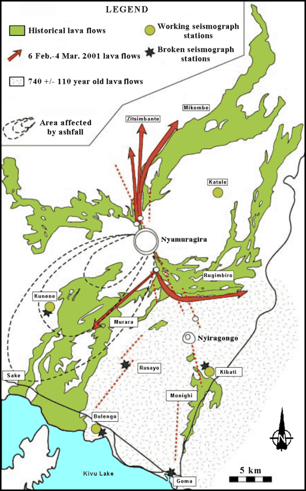 |
Figure 18. Map of historical lava flows at Nyamuragira and Nyiragongo (shaded). Nyamuragira lava flows from 6 February to 4 March 2001 are indicated by arrows. For a more detailed map of historical lava flows and their ages, see BGVN 19:06. Courtesy of the Goma Volcanological Observatory. |
While the intensity of the lava flows decreased in mid-March, registered seismicity was at similar levels to December 2000, shortly before the eruption began. This is an unusual pattern for Nyamuragira; tremor usually ends at the same time as the eruption. Local volcanologists believe this indicates lava and pressure remaining within either Nyamuragira or Nyiragongo, ~15 km to the SE.
TOMS observations. An SO2 cloud probably associated with the February 2001 eruption of Nyamuragira was first detected by the Earth Probe Total Ozone Mapping Spectrometer (TOMS) on 6 February. TOMS image resolution is not sufficient to distinguish between Nyamuragira and nearby Nyiragongo as the source (consequently the images referred to below will provisionally remain associated with both volcanos). The well-defined cloud extended ~800 km NW from the volcano across the Democratic Republic of Congo on 6 February (figure 19a), covering an area of ~160,000 km2, with the highest SO2 values concentrated in a narrow band towards the N edge of the plume. Preliminary analysis indicates that this cloud contained ~230 kilotons (kt) of SO2. TOMS imagery on 7 February showed a diffuse SO2 cloud (estimated SO2 mass ~80 kt) over Cameroon and Congo, and high levels of SO2 WSW of Nyamuragira (truncated by a gap between TOMS swaths; figure 19b). On 8 February, reduced levels of SO2 (estimated mass ~150 kt) were measured in a bifurcating cloud that extended ~500 km WNW and ~200 km SW from the volcano (figure 19c); this appeared to have largely dispersed by the next day. On 10 February TOMS detected a region of dissipating SO2 ~950 km W of Nyamuragira (estimated SO2 mass ~10 kt), and another cloud (detached from the volcano) extending ~250 km SW (estimated SO2 mass ~10 kt). Small, isolated SO2 signals were detected sporadically near the volcano until 6 March.
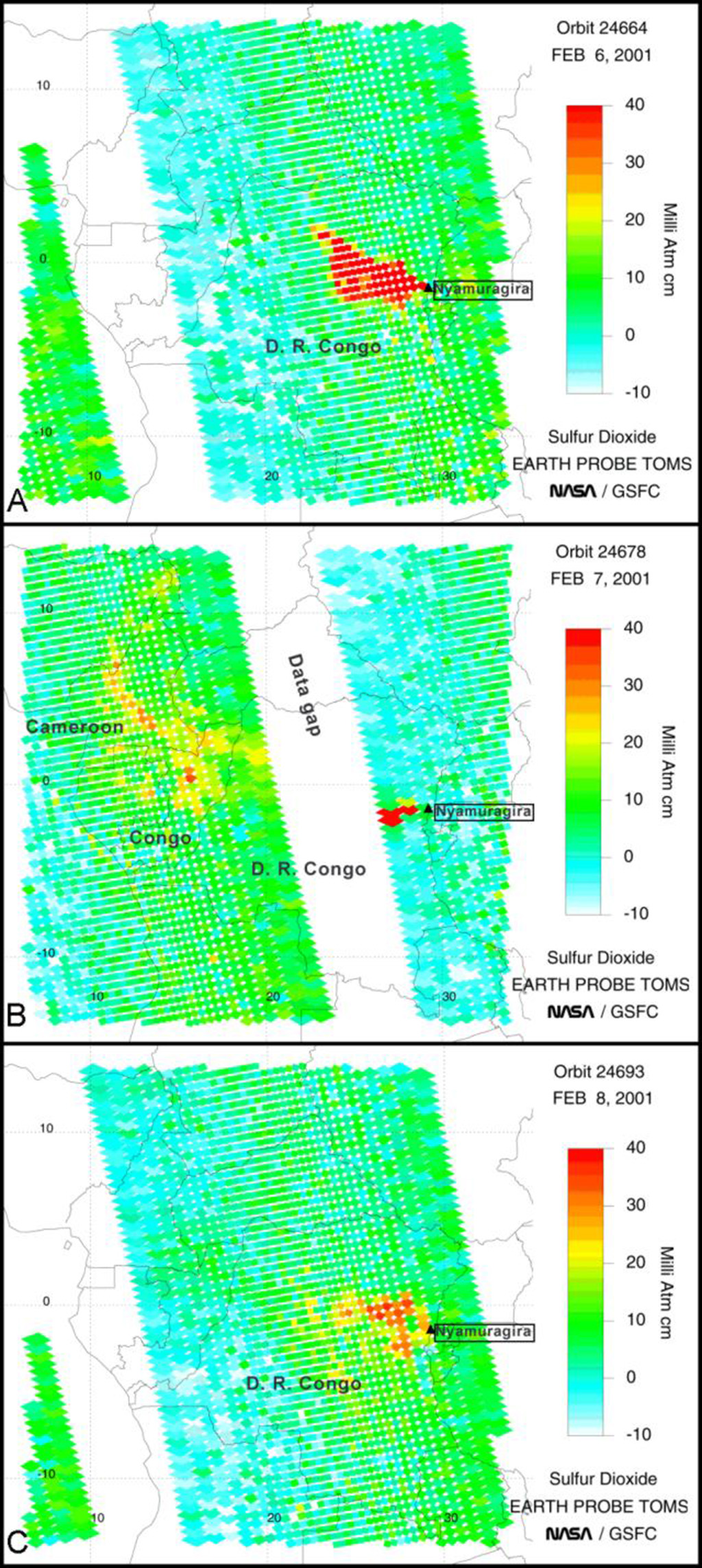 |
Figure 19. Images of an SO2 cloud associated with the February 2001 eruption of Nyamuragira (or possibly Nyiragongo) detected by the Earth Probe Total Ozone Mapping Spectrometer (TOMS) on (a) 6 February, (b) 7 February, and (c) 8 February. Courtesy of Simon Carn, NASA/UMBC. |
Geological Summary. Africa's most active volcano, Nyamulagira (also known as Nyamuragira), is a massive high-potassium basaltic shield about 25 km N of Lake Kivu and 13 km NNW of the steep-sided Nyiragongo volcano. The summit is truncated by a small 2 x 2.3 km caldera that has walls up to about 100 m high. Documented eruptions have occurred within the summit caldera, as well as from the numerous flank fissures and cinder cones. A lava lake in the summit crater, active since at least 1921, drained in 1938, at the time of a major flank eruption. Recent lava flows extend down the flanks more than 30 km from the summit as far as Lake Kivu; extensive lava flows from this volcano have covered 1,500 km2 of the western branch of the East African Rift.
Information Contacts: Wafula Mifundu, Observatore Volcanologie de Goma (RDC-E), Goma, Democratic Republic of Congo; Jim Smith, US Agency for International Development / Office of US Foreign Disaster Assistance, 1300 Pennsylvania Ave., NW, Washington, DC 20523-8602 USA (URL: https://www.usaid.gov/who-we-are/organization/bureaus/bureau-democracy-conflict-and-humanitarian-assistance/office-us); Simon Carn, Joint Center for Earth Systems Technology (NASA/UMBC), University of Maryland Baltimore County, 1000 Hilltop Circle, Baltimore, MD 21250 USA.