Report on Toya (Japan) — March 2001
Bulletin of the Global Volcanism Network, vol. 26, no. 3 (March 2001)
Managing Editor: Richard Wunderman.
Toya (Japan) Explosive activity, major uplift, and fault formation during 31 March-early May 2000
Please cite this report as:
Global Volcanism Program, 2001. Report on Toya (Japan) (Wunderman, R., ed.). Bulletin of the Global Volcanism Network, 26:3. Smithsonian Institution. https://doi.org/10.5479/si.GVP.BGVN200103-285030
Toya
Japan
42.544°N, 140.839°E; summit elev. 733 m
All times are local (unless otherwise noted)
As reported in BGVN 25:03, an eruption at Usu began on 31 March 2000 following several days of increased seismicity. A description of eruption precursors was presented in BGVN 25:06. This report summarizes activity between the 31 March eruption and early May 2000. Vigorous activity continued throughout April 2000 (figures 29 and 30), and activity was continuing in May.
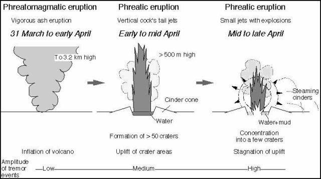 |
Figure 29. Schematic illustration showing the eruption sequence at Usu during 31 March-late April 2000. Courtesy of VRC, ERI. |
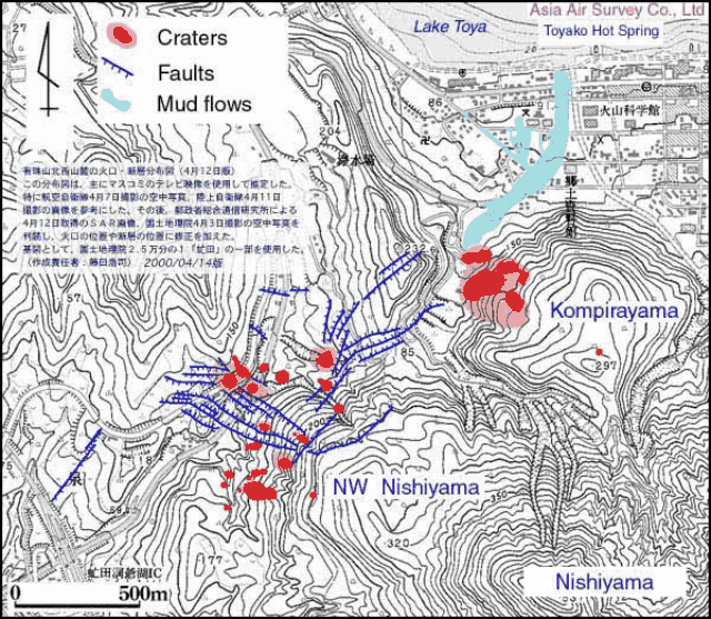 |
Figure 30. Map showing the distribution of active craters, faults, and mudflows as of 14 April 2000. Usu's summit rises to the S, outside the map area. Courtesy of Asia Air Survey Co. Ltd. |
According to the Geographical Survey Institute, the region including the crater areas was elevated 3.3 m/day during the three days from 31 March to 3 April, suggesting the formation of a new cryptodome similar to Meiji-Shinzan, a cryptodome that formed on Usu's N flank in 1910 and Showa-Shinzan, a cryptodome and lava dome that formed during 1944-45 (figure 31).
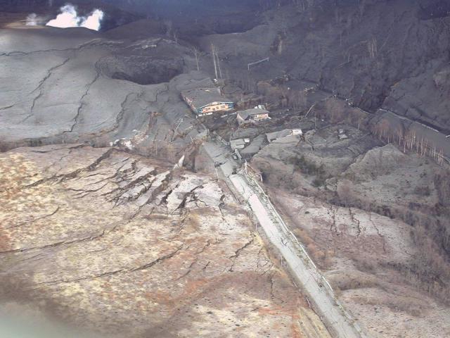 |
Figure 31. View from a helicopter facing N on 17 April 2001, showing multiple steaming vents in the background and several faults formed by uplift of the NW Nishi-yama area. Courtesy of S. Nakada. |
Around 6 April 2000, the eruption style changed from phreatomagmatic ash emissions to phreatic ejection of vertical cock's-tail jets reaching 500 m above the craters. By 10 April, more than 30 craters had formed in the Kompira-yama and NW Nishi-yama areas (figures 30 and 32). Cinders ejected by the continuing explosions steamed after they landed around the craters. The temporal changes in eruption style can be explained by assuming that the magma approached an overlying aquifer, estimated to lie between 0 and 300 m below sea level, and passed almost directly through it. According to the Usu Volcano Observatory, the amplitude of volcanic tremors increased after 6 April and increased further after 12 April.
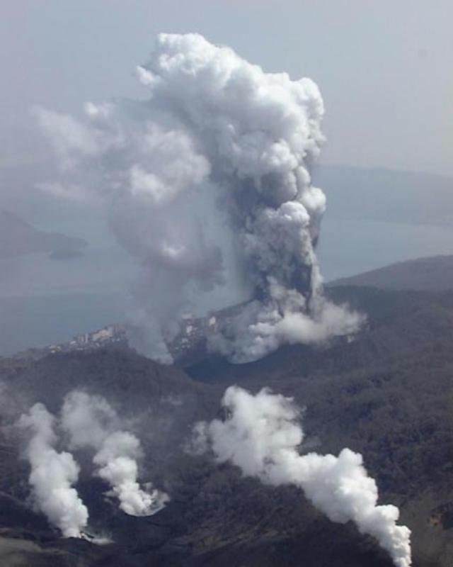 |
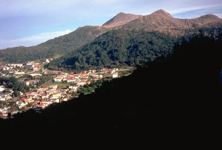
Figure 32. View from a helicopter looking NE on 10 April 2001, showing multiple active vents within the Kompira-yama (center) and NW Nishi-yama (foreground) crater areas. Toyako Hot Spring and town lie in the background. Courtesy of S. Nakada. |
Eruptions continued though late April, although plume activity decreased. White clouds were emitted from the Kompira-yama and NW Nishi-yama craters. Small explosions were observed. Cinders ejected from NW Nishi-yama dusted the Kompira-yama craters. The plumes frequently darkened with ash, implying partial collapse of vent walls. The principal active craters in both areas grew to a few hundred meters across and had dry funnel-shaped floors.
Uplift continued at a decreased rate in the NW Nishi-yama area. The total height of the uplift was 60 m by the end of April according to an air-photo survey by the Geographical Survey Institute. Uplift was < 20 m for the Kompira-yama area except for the crater rims. The total volume of uplift in the two crater areas was estimated to be ~40 x 106 m3; one order of magnitude smaller than the volume of the 1944-45 Showa-Shinzan dome. According to the Joint University Research Group, the uplift rate was the highest in the initial stage of eruption and decreased exponentially to ~10 cm/day by early May.
Geological Summary. Usuzan, one of Hokkaido's most well-known volcanoes, is a small stratovolcano located astride the southern topographic rim of the 110,000-year-old Toya caldera. The center of the 10-km-wide, lake-filled caldera contains Nakajima, a group of forested Pleistocene andesitic lava domes. The summit of the basaltic-to-andesitic edifice of Usu is cut by a somma formed about 20-30,000 years ago when collapse of the volcano produced a debris avalanche that reached the sea. Dacitic domes erupted along two NW-SE-trending lines fill and flank the summit caldera. Three of these domes, O-Usu, Ko-Usu and Showashinzan, along with seven crypto-domes, were erupted during historical time. The 1663 eruption of Usu was one of the largest in Hokkaido during historical time. The war-time growth of Showashinzan from 1943-45 was painstakingly documented by the local postmaster, who created the first detailed record of growth of a lava dome.
Information Contacts: Setsuya Nakada and Hidefumi Watanabe, Volcano Research Center, Earthquake Research Institute, University of Tokyo, Yayoi 1-1-1, Bunkyo-ku, Tokyo 113-0032, Japan (URL: http://www.eri.u-tokyo.ac.jp/VRC/index_E.html); Geological Survey of Japan, 1-1-3 Higashi, Ibaraki, Tsukuba 305, Japan (URL: https://www.gsj.jp/); Geographical Survey Institute of Japan (URL: http://www.gsi-mc.go.jp/); Usu Volcano Observatory, Institute of Seismology and Volcanology, Graduate School of Science, Hokkaido University, Sohbetsu-cho, Usu-gun, Hokkaido, 052-0103, Japan (URL: http://www.sci.hokudai.ac.jp/isv/english/); Tatsuro Chiba, Asia Air Survey Co. Ltd..