Report on Klyuchevskoy (Russia) — April 2001
Bulletin of the Global Volcanism Network, vol. 26, no. 4 (April 2001)
Managing Editor: Richard Wunderman.
Klyuchevskoy (Russia) Consistent gas-and-steam emissions; high seismicity
Please cite this report as:
Global Volcanism Program, 2001. Report on Klyuchevskoy (Russia) (Wunderman, R., ed.). Bulletin of the Global Volcanism Network, 26:4. Smithsonian Institution. https://doi.org/10.5479/si.GVP.BGVN200104-300260
Klyuchevskoy
Russia
56.056°N, 160.642°E; summit elev. 4754 m
All times are local (unless otherwise noted)
The following report covers the interval of 30 December 2000-10 May 2001, during which Kliuchevskoi had a maximum Level of Concern Color Code of Yellow. Since the previous report (BGVN 25:09), gas-and-steam plumes rose from the volcano throughout the entire report period. During 30 December 2000-1 February 2001, seismicity remained at background levels and fumarolic plumes rose up to 1,000 m. Strong shallow earthquakes were subsequently recorded on 4 and 18 February. Gas-and-steam plumes continued to rise and reached a maximum height of 1,200 m above the summit through 22 February.
Beginning during 22-24 and 27-28 February, episodes of weak spasmodic tremor were registered. Weak interrupted tremor continued during 2-29 March. On 4 March the Kamchatka Volcanic Eruptions Response Team (KVERT) reported a gas-and-steam plume with a maximum height of 1,000 m extending 10 km NE of the volcano. Satellite imagery detected the large plume and prompted the Tokyo Volcanic Ash Advisory Center (VAAC) to issue an ash advisory the same day despite no reported detection of ash by KVERT. From 1925 to 1940 on 15 March seismographs recorded an intense series of shallow earthquakes. Gas-and-steam plumes reached heights of 2,000 m during mid-March. At about this time KVERT raised the hazard level of Kliuchevskoi from Green to Yellow.
The level of volcanic tremor began to gradually increase again at 1000 on 7 April; a significantly high level of tremor occurred at 1300 on the same day. At 0717 on 8 April seismicity increased sharply with a swarm of shallow earthquakes (M ~ 2) accompanied by volcanic tremor. No eruptive activity was observed, and after 0900 activity decreased substantially. Similar low-level seismicity continued through 12 April, and KVERT decreased the volcano's hazard level from Yellow to Green following this date.
Elevated seismicity continued at 1259 on 13 April with a strong earthquake (M ~ 5) that occurred between Kliuchevskoi and Ushkovsky volcanoes at a depth of ~12 km. Aftershocks of this event (M <= ~ 4.2) continued to occur through 19 April. Small shallow earthquakes were also registered. During 20 April-10 May low-level fumarolic activity was prevalent with plumes that rose up to 1,500 m and background-level seismicity. KVERT maintained a hazard status of GREEN as of 10 May 2001.
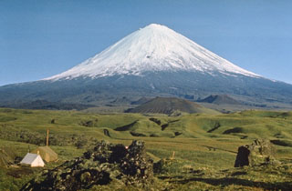
Geological Summary. Klyuchevskoy is the highest and most active volcano on the Kamchatka Peninsula. Since its origin about 6,000 years ago, this symmetrical, basaltic stratovolcano has produced frequent moderate-volume explosive and effusive eruptions without major periods of inactivity. It rises above a saddle NE of Kamen volcano and lies SE of the broad Ushkovsky massif. More than 100 flank eruptions have occurred during approximately the past 3,000 years, with most lateral craters and cones occurring along radial fissures between the unconfined NE-to-SE flanks of the conical volcano between 500 and 3,600 m elevation. Eruptions recorded since the late 17th century have resulted in frequent changes to the morphology of the 700-m-wide summit crater. These eruptions over the past 400 years have originated primarily from the summit crater, but have also included numerous major explosive and effusive eruptions from flank craters.
Information Contacts: Olga Chubarova, Kamchatka Volcanic Eruptions Response Team (KVERT), Institute of Volcanic Geology and Geochemistry, Piip Ave. 9, Petropavlovsk-Kamchatsky, 683006, Russia; Tom Miller, Alaska Volcano Observatory (AVO), a cooperative program of a) U.S. Geological Survey, 4200 University Drive, Anchorage, AK 99508-4667, USA (URL: http://www.avo.alaska.edu/), b) Geophysical Institute, University of Alaska, PO Box 757320, Fairbanks, AK 99775-7320, USA, and c) Alaska Division of Geological & Geophysical Surveys, 794 University Ave., Suite 200, Fairbanks, AK 99709, USA; Tokyo Volcanic Ash Advisory Center (VAAC), Tokyo, Japan (URL: https://ds.data.jma.go.jp/svd/vaac/data/).