Report on Masaya (Nicaragua) — April 2001

Bulletin of the Global Volcanism Network, vol. 26, no. 4 (April 2001)
Managing Editor: Richard Wunderman.
Masaya (Nicaragua) Tourists experience a brief, bomb-charged 23 April 2001 explosion: no fatalities
Please cite this report as:
Global Volcanism Program, 2001. Report on Masaya (Nicaragua) (Wunderman, R., ed.). Bulletin of the Global Volcanism Network, 26:4. Smithsonian Institution. https://doi.org/10.5479/si.GVP.BGVN200104-344100
Masaya
Nicaragua
11.9844°N, 86.1688°W; summit elev. 594 m
All times are local (unless otherwise noted)
INETER report. The Nicaraguan group INETER (Instituto Nicaragüense de Estudios Territoriales) stated that Masaya's active summit crater, Santiago, produced an explosion at 1426 on 23 April. The explosion continued for ~2 minutes and a new 10-m-diameter vent opened on the crater floor ~30 m S of the previous vent. Fragments up to 60 cm in diameter flew through the air, falling up to 500 m from the crater. Episodic ashfall was reported near the settlement of Tecuantepe, 6 km NW of Masaya volcano, and people there contended with abnormal concentrations of volcanic gases. Scientists from Cambridge University (UK) who carried out gas measurements at Santiago crater left just one hour before the explosion and had not noticed any unusual precursory behavior. Preliminary, post-event scrutiny of the seismicity failed to reveal precursory signs.
After the explosion, the volcano returned to its typical stable state and monitored parameters remained at normal levels. INETER volcanologists who continuously monitored Santiago in the afternoon and during the night reported several smaller explosions, gas outbreaks and minor collapses of the crater wall. Following the explosion, Masaya National Park closed public access to the crater-rim areas (including the Plaza Sapper visitor platform and parking lot) for the next several days.
The 24 April report noted minor ash-bearing explosions (specifically mentioning one at 1526), but these events did not exceed those typically seen nor did they accompany abnormally large seismic signals. On this day, the previously active vent no longer gave off gases. The report noted that in the current circumstances, the area of primary hazard lay within 500 m of the vent. It also said that areas farther out, particularly as far away as local habitations or along the Managua-Masaya highway, should not be affected.
SO2 monitoring at the visitor's plaza was conducted at 1020 on 24 April. It indicated that, with respect to 23 April at 1800, the ambient gas concentration there had decreased more than 72%. Since these were not flux measurements but were only ambient SO2 concentrations, fresh winds may have contributed to the decreased concentrations. The 25 April report on Masaya noted slightly larger output than the day before, including ash deposition, but noted 29% lower SO2 concentration than the day before. In harmony with the SO2 concentration decrease on 25 April, sulfurous gases then measured ~2.0 ppm in local settlements (Comarcas La Borgoña and San José de los Ríos), half the value measured the previous day.
The 27 April report noted few episodes of strong degassing during the previous two days, but normal tremor and little seismicity. A second seismic station was installed on the volcano at a spot near the visitor's platform.
23 April eyewitness account and photos. What started out as a routine sightseeing stop escalated into a local crisis as over 120 tourists found themselves on the crater rim during what was one of the more energetic Masaya explosions reported in the Bulletin in the past 30 years. Few, if any, of those earlier events had been witnessed at close range, and in retrospect it seems fortuitous that in this event no one was killed.
The event highlights the difficulty of assessing, preparing for, and conveying the possibility of infrequent, sudden events. The accompanying photos document the ambiguity of assessing the event's magnitude during the explosion's critical early stages. After the event, the majority of eye witnesses with photographs and videos quickly departed from Nicaragua, having shared almost no information with authorities.
Figures 13-19 show selected scenes the tourists captured on film during and just after the explosion. The photos were taken from the 500-m-diameter Santiago crater's N side (for maps of the crater area see SEAN 14:06 and BGVN 16:02). Figures 13-17 are in chronological order; figures 17-19 show selected scenes in the aftermath of the explosion, after the parking area had been largely vacated of vehicles.
The buses were parked in the crater rim area's N parking area. Progressing upslope and along the crater rim, a foot trail leads to the elevated overlook (~200 m W of the parking lot's center). During the explosion this trail became very exposed to ash and ballistics. Although not shown on any of the included photos, a large cross stands at the elevated overlook in the vicinity of where many of the photographers were standing at the time of the eruption (not shown in figures here but labled "La Cruz" on maps in earlier Bulletins).
The photos were furnished to the Bulletin by Joanne Gordon; Mark Headrick also helped explain the significance of some features in the photos. Photos shot by Headrick used an auto-focusing camera with a fixed-focus lens.
Figures 13-15 show the early progression of the ash- and bomb-charged plume. Although in these photos the rising plume can be seen blown towards the W, during the explosion significant numbers of bombs also fell well beyond the plume's margins. For example, some bombs began pelting the N parking lot, forcing people there to take shelter in buses and cars. Fortunately, comparatively few bombs were launched over the local high adjacent the NNW rim where photographers shot figures 13-16. The tens of tourists who had stood at the elevated overlook later retreated in haste cross-country down the hill's more sheltered but trackless back-side (figure 16).
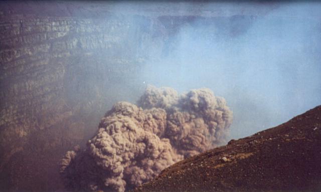 |
Figure 13. The earliest of several available photos taken of Masaya's 23 April 2001 explosion that vented from Santiago crater. This photo was taken looking SW from the elevated overlook on the NNW rim. The crater floor appears as the dark zone in the lower left-hand corner. Photo credit: Lillian Reyes. |
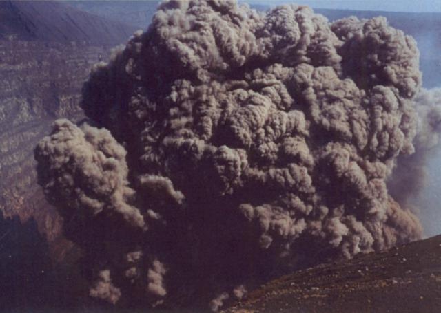 |
Figure 14. In this view from the elevated overlook on the NNW crater rim of Masaya, the ash- and bomb-laden plume-top had risen slightly above the rim early in the 23 April eruption. Photo credit: Jay Barron. |
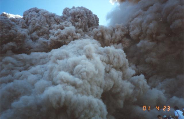 |
Figure 15. The steam- and ash-dominated clouds from Masaya's 23 April 2001 explosion rose well above the crater rim before the hazard presented by the explosion was universally recognized. Among the onlookers in the lower-right of the photograph is a small baby wearing a broad-brimmed hat (second from left). Photo credit: Jay Barron. |
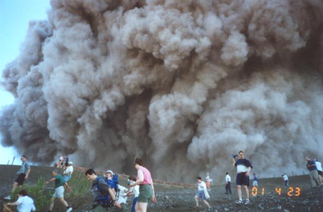 |
Figure 16. Masaya's 23 April 2001 explosion taken in a southward-looking direction on the backside of the elevated overlook. The scene clearly shows tourists making a hasty off-trail retreat away from the crater rim. Photo credit: Mark Headrick. |
Figures 17 and 18 show portions of the bomb-strewn parking lot. Many bombs of roughly half-liter to several-liters in volume can be easily seen. Parking stalls in the lot can be assumed to be roughly 2 x 3 m in size (~6 m2) and typically contain about 1 to 3 such bombs. This implies that on average, roughly 1 such bomb landed in each 2 to 3 m2 area.
Some bombs landing in the parking lot broke into bits on impact and sprayed local areas of the lot with their light-colored fragments (figure 18). Both figures 17 and 18 document local, sometimes circular grass fires, suggesting that some of the bombs were hotter than the several hundred degree kindling temperature of the dry, brown vegetation. Several bombs significantly damaged vehicles in the lot, causing fires, breaking windows, and puncturing and deforming bus roofs. One bomb landed in a then-unoccupied bus seat, and another plowed deep into the hood and engine compartment of a car (figure 19).
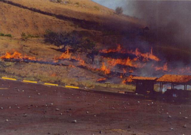 |
Figure 17. Fresh bombs litter the N parking area (foreground) as a result of the 23 April Masaya eruption. Tour buses had been parked adjacent the tile-roofed shelters but had moved by the time this shot was taken. Hot ejecta started grass fires, which can be seen in this photograph still burning on the slope behind the shelters. Photo credit: Mark Headrick. |
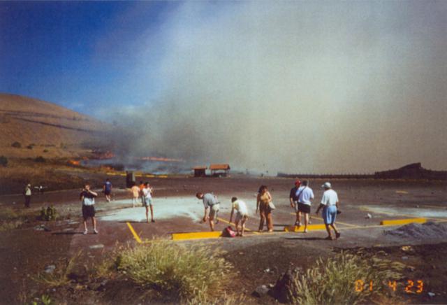 |
Figure 18. Following Masaya's 23 April explosion, tourists who had been at the elevated overlook regrouped at the edge of the bomb-strewn N parking lot. Some bombs shattered into small aggregates that left several light-colored arrays splashed across the pavement. Fires and smoke appear in the background. Photo credit: Mark Headrick. |
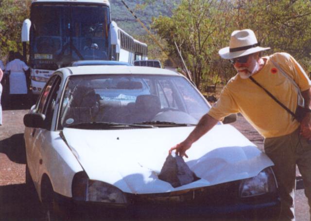 |
Figure 19. A ballistic bomb from Masaya's 23 April eruption ended up lodged in a passenger car's hood. The car was occupied at the time of the incident but there were only minor injuries. Photo credit: Pamela Tores. |
Joanne Gordon recounted the events of 23 April as follows: "While traveling by cruise ship from Costa Rica through the Panama Canal towards our final destination of Aruba, we made a one-day stop in Nicaragua for a city bus tour. The Nicaragua stop was the second day of our seven-day cruise. Approximately 150 cruisers [in] five buses were scheduled for the city tour and a short visit to Masaya volcano. The first two buses visited the volcano and were scheduled to have ~ 30 minutes to view the crater. Many of the tourists reported that the odor of sulfur greatly increased during their visit . . . . Those two buses left before the following three buses arrived.
"I was on the last bus to arrive at the crater. After getting off the bus my brother and I excitedly ascended to the top lookout point next to the cross overlooking the lip of the crater. The climb to the top of the crater was about 200 steps up a very unstable staircase . . . . Once we arrived at the top I took a few pictures of the crater and of us. Then I heard a deep rumble and the ground began to shake. It sounded as if it was a huge landslide at the opposite side of the crater. Within seconds I could see a massive black mushroom-shaped cloud of smoke filling the inside of the crater. At that point I ran–thinking, 'Is this normal?' but not wanting to stand at the edge of the crater to find out.
" . . . I ran down the [steep] back side of the hill not realizing it was like running down a slope of marbles . . . . Then I heard a second boom followed by more black smoke, and I heard rocks being thrown from the crater—people screaming—children crying . . . . "I heard a little girl's voice . . . [then] I lost my footing and rolled down the hill. After falling for the second time, I stopped to look for her. She had fallen and was caught on some brush. I could see the sky was black but the smoke was moving away from us and the explosion had stopped. I waited with her, trying to calm her . . . . I could see her dad and my brother rushing down the hill trying to keep from falling. When they caught up to us we traversed our way down the hill to the buses, which had been parked about 10-15 feet [3-5 m] from the crater and had now moved out of sight. They had driven away, moving out from under the shower of rocks.
"At this point I had thought it was just the 30-50 people crowded at the top lookout point that were in danger. Little did I know that while I was running to get away from the blast of smoke from the top, the people at the bottom were dodging rocks. It looked like a war zone. Bus windows [had] broken . . . [and (according to Mark Headrick) one bus with its backside facing the crater suffered extensive damage from ejecta, including the loss of its rear window and severe damage to the fiberglass engine cowling. The damage went deeper, and although it drove a short distance away, this bus soon ceased functioning and had to be abandoned]. One lava rock had landed on the top of a bus, and . . . [wedged into the roof where it caught fire to combustible material]. People [were] bleeding, limping, crying, and desperate to get as far away as possible. The hillside next to the parking lot was filled with burned circles. As the lava rocks hit the ground they caught fire to the surrounding brush.
"We all piled on buses and drove a little ways to the park entrance to make sure all were accounted for. I got out of the bus for first aid. I suffered abrasions down both of my arms and legs . . . . We all wanted to get in the buses and get the heck away from the mountain as quickly as possible. We left just before the news cameras and fire department arrived. We drove for about an hour and a half back to the port to board the ship and . . . [departed] Nicaragua.
"At least 15 of the 90 people on the last buses were treated by the ship's infirmary for wounds ranging from a broken arm [wrist], broken foot, abrasions, and cuts and bruises from falling or being struck by rocks. Most of the people that were struck with rocks were injured after the rocks bounced and hit the legs, shoulders, and backs.
" . . . [the cruise line] was very accommodating—they flew a crisis counselor to the ship to comfort the passengers and the 28 crew members that were also at the volcano."
Report from the ship's doctor. Medical doctor Sydney Schneidman practices emergency medicine and was the acting physician on board the cruise ship, which was moored at San Juan del Sur when the accident occurred. As injured people returned to the ship, Schneidman quickly learned that the people suffered from both physical and psychological trauma, and many of the injuries within each of these groups were quite similar.
He recalled that the most serious physical injury was a broken wrist due to a fall. This and many other injuries to 10-15 people occurred when people fleeing the fallout took the steep, off-trail escape route described above. The visitors were forced to move quickly in this direction because flying debris blocked the trail leading back to the parking lot and the buses. Many of the abrasions obtained on this forced evacuation route were leg wounds from sharp-edged volcanic rocks. In addition, Schneidman noted two or three missile injuries, one a head puncture, two others to the flank (side of the stomach), and one to a hip. (Joanne Gordon noted that a broken foot bone sustained by one of the passengers was diagnosed sometime after the trip was over.)
Regarding the psychological aspect of the injuries, Schneidman described these as mental trauma from people who thought they were going to die. He advised the visitors be treated without delay by a psychologist skilled in dealing with "critical-instance stress" (CIS) debriefing, and when in Panama one day later, the cruise ship had arranged to pick up a psychologist flown in from the USA specializing in trauma counseling. Over the next several days the psychologist held group therapy sessions. Studies have shown that rapid treatment for trauma can circumvent or decrease several years of difficulties, including sleeplessness, anxiety, and depression (Goenjian and others, 2000; Schmookler, 1996).
Media coverage. The explosion and its effect on tourists were discussed in news articles in the Los Angeles Times and at least one other Southern-California paper (Reich, 2001; Lee, 2001). The television show Inside Edition aired videos and photos taken of the explosion by visitors returning from the cruise ship (Inside Edition, 2001). At the time, Nicaraguan papers covering the story included few if any details about the experiences of the tourists from the cruise ship because they lacked contact with them.
References. Goenjian, A.K., Steinberg, A.M., Najarian, L.M., Fairbanks, L.A., Tashjian, M., and Pynoos, R.S. , 2000, Prospective study of posttraumatic stress, anxiety, and depressive reactions after earthquake and political violence: American Journal of Psychiatry, v. 157, no. 6, p. 911-916.
Inside Edition, 2001, Volcano survivors: King World Productions, 8 May 2001 telecast (video ordering information at the phone number 212-817-5656 ext. 5583); 515 W 57th St., New York, NY 10019 USA.
Lee, Jasmine, 2001, Tested by fire—Area residents recount terror of volcano blast in Nicaragua: Daily Breeze (A Copley Newspaper, Torrance, CA), 3 May 2001, p. A1 and A9.
Reich, Kenneth, 2001, Volcano's eruption shook up vacation of southland sisters—Nicaragua: The two dodged rocks and ash on a sightseeing stop at a crater during a Latin American cruise; one broke her arm: Los Angeles Times, Metro News, 3 May 2001, p. B2.
Schmookler, Edward L., 1996, Trauma treatment manual (URL: http://amsterdam.park.org/Guests/Stream/ trauma_manual.htm).
Geological Summary. Masaya volcano in Nicaragua has erupted frequently since the time of the Spanish Conquistadors, when an active lava lake prompted attempts to extract the volcano's molten "gold" until it was found to be basalt rock upon cooling. It lies within the massive Pleistocene Las Sierras caldera and is itself a broad, 6 x 11 km basaltic caldera with steep-sided walls up to 300 m high. The caldera is filled on its NW end by more than a dozen vents that erupted along a circular, 4-km-diameter fracture system. The Nindirí and Masaya cones, the source of observed eruptions, were constructed at the southern end of the fracture system and contain multiple summit craters, including the currently active Santiago crater. A major basaltic Plinian tephra erupted from Masaya about 6,500 years ago. Recent lava flows cover much of the caldera floor and there is a lake at the far eastern end. A lava flow from the 1670 eruption overtopped the north caldera rim. Periods of long-term vigorous gas emission at roughly quarter-century intervals have caused health hazards and crop damage.
Information Contacts: INETER, Apartado Postal 2110, Managua, Nicaragua; Joanne Gordon, 222 East Carrillo, Ste. 106, c/o PaineWebber, Santa Barbara, CA 93101 USA; Sydney Schneidman, M.D., 1757 Holicong Rd., New Hope, PA 18938 USA.