Report on Ahyi (United States) — May 2001
Bulletin of the Global Volcanism Network, vol. 26, no. 5 (May 2001)
Managing Editor: Richard Wunderman.
Ahyi (United States) Brief explosive activity on 24 April 2001 detected seismically
Please cite this report as:
Global Volcanism Program, 2001. Report on Ahyi (United States) (Wunderman, R., ed.). Bulletin of the Global Volcanism Network, 26:5. Smithsonian Institution. https://doi.org/10.5479/si.GVP.BGVN200105-284141
Ahyi
United States
20.42°N, 145.03°E; summit elev. -75 m
All times are local (unless otherwise noted)
A short episode of explosive submarine volcanism was recorded 24 April 2001 by the Laboratoire de Géophysique's (LDG) Pomariorio (PMO) seismic station on Rangiroa Atoll, Tuamotu Archipelago. This episode began at 1110 UTC, and ended at 1900 UTC, with more than 40 explosive T-waves at a fairly uniform rate. The wave forms were similar to those of December 1989 (from a source NW of Supply Reef, SEAN 14:12), and suggested a source in the Mariana Islands. LDG scientists identified these explosive events on records from some other IRIS and Freesia stations, and computed a well-constrained location at 20.34°N, 145.02°E with an error of 15 km (figure 1).
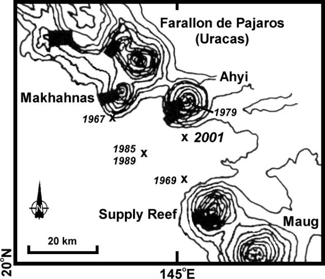 |
Figure 1. Map showing Ahyi and other volcanic edifices along part of the Mariana Arc just north of 20°N, 145°E. The location of the April 2001 activity is indicated, as well as activity reported between Farallon de Pajaros and Supply Reef in 1967, 1969, 1979, 1985, and 1989. Contour interval is 200 m; bathymetry is based on US Navy narrow-beam SASS data. Thick black bars show 1985 dredge locations. Scale and volcanic activity locations are approximate. Base map modified from Bloomer and others (1989). |
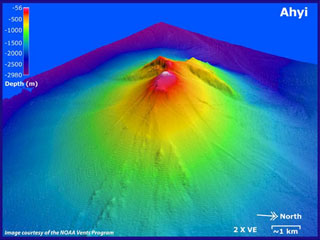
The summit of Ahyi lies within this location uncertainty, approximately 10 km N. Ahyi seamount is a large conical submarine volcano that rises to within about 140 m of the sea surface about 18 km SE of Farallon de Pajaros. Water discoloration has been observed over the volcano, and in 1979 the crew of a fishing boat felt shocks over the summit area followed by upwelling of sulfur-bearing water (SEAN 04:11).
Regional volcanic activity. Most of the recent historical activity in this area is based on acoustic detection methods from great distances, making exact location determinations difficult. The following presents background information about other volcanoes close to the April 2001 event, with a description of recent volcanism.
The small 2-km-wide island of Farallon de Pajaros (also known as Uracas) is the northernmost and most active volcano of the Mariana Islands. Its relatively frequent historical eruptions dating back to the mid-19th century have caused it to be referred to as the "lighthouse of the western Pacific." Flank fissures have fed historical lava flows that form platforms along the coast. Summit vents have also been active during historical time, and eruptions have been observed from nearby submarine vents. Aerial observations of fuming were reported in July 1981 (with discolored water), August 1990, and May 1992. Makhahnas seamount, which rises to within 640 m of the sea surface, lies about 10 km SW. A possible eruption during March-April 1967 on the SW flank of this seamount was identified on the basis of T-phase recordings by Norris and Johnson (1969).
Supply Reef is a conical submarine volcano that rises to within 8 m of the sea surface. The seamount lies about 10 km NW of the Maug Islands, the emergent summit of a submarine volcano that is joined to Supply Reef by a low saddle at a depth of about 1,800 m. Several submarine eruptions have been detected by sonar signals originating from points very approximately located at distances of 15-25 km NW of Supply Reef. An event in March 1969 was detected using T-phase recordings and located by the crew of a fishing boat who heard explosion sounds and saw water discoloration (CSLP Cards 528 and 534). Activity in August-September 1985 (SEAN 10:09 and 10:11) and September and December 1989 (SEAN 14:10 and 14:12) were in the same approximate location, 30 km S of Farallon de Pajaros, about midway between Makhahnas and Supply Reef. Both of these events were identified and located using T-phase data, but discolored water was also observed during the 1985 event by an airline pilot.
References. Bloomer, S.H., Stern, R.J., and Smoot, N.C., 1989, Physical volcanology of the submarine Mariana and Volcano arcs: Bulletin of Volcanology, v. 51, p. 210-224.
Norris, R.A., and Johnson, R.H., 1969, Submarine volcanic eruptions recently located in the Pacific by Sofar hydrophones: Journal of Geophysical Research, v. 74, no. 2, p. 650-664.
Geological Summary. Ahyi seamount is a large conical submarine volcano that rises to within 75 m of the ocean surface ~18 km SE of the island of Farallon de Pajaros in the northern Marianas. Water discoloration has been observed there, and in 1979 the crew of a fishing boat felt shocks over the summit area, followed by upwelling of sulfur-bearing water. On 24-25 April 2001 an explosive eruption was detected seismically by a station on Rangiroa Atoll, Tuamotu Archipelago. The event was well constrained (+/- 15 km) at a location near the southern base of Ahyi. An eruption in April-May 2014 was detected by NOAA divers, hydroacoustic sensors, and seismic stations.
Information Contacts: Olivier Hyvernaud, Laboratoire de Géophysique, PO Box 640, Pamatai, Tahiti, French Polynesia.