Report on Vailulu'u (United States) — June 2001
Bulletin of the Global Volcanism Network, vol. 26, no. 6 (June 2001)
Managing Editor: Richard Wunderman.
Vailulu'u (United States) Description of submarine volcano at the end of the Samoan chain
Please cite this report as:
Global Volcanism Program, 2001. Report on Vailulu'u (United States) (Wunderman, R., ed.). Bulletin of the Global Volcanism Network, 26:6. Smithsonian Institution. https://doi.org/10.5479/si.GVP.BGVN200106-244000
Vailulu'u
United States
14.215°S, 169.058°W; summit elev. -592 m
All times are local (unless otherwise noted)
Recent work by Hart and others (2000) has described this volcano and identified it as the source of acoustic signals noted in July 1973 and an earthquake swarm during January 1995 (BGVN 20:01 and 20:02). The following is from Hart and others (2000) except where noted.
Vailulu'u Seamount is located 45 km east of Ta'u island, the easternmost island of the Samoan chain, and defines the leading edge of the Samoan swell (figure 2). Mapped in March 1999 with SeaBeam aboard the RV Melville during AVON cruises 2 and 3 (figures 2 and 3), Vailulu'u rises from an ocean depth of 4,800 m to its crater rim within 590 m of the sea surface, with a total volume of ~1,050 km3. The summit includes a 400-m-deep, 2-km-wide crater (figure 4). These cruises were motivated by the 1973 and 1995 acoustic and seismic events in this region, and were a direct attempt to find the current location of the Samoan hotspot.
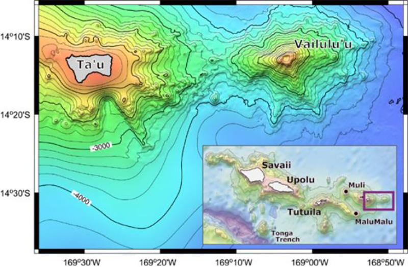 |
Figure 2. Bathymetry of Vailulu'u and nearby Ta'u Island, based on a SeaBeam bathymetric survey performed during R/V Melville's AVON 2 and 3 cruises, augmented with satellite-derived bathymetry from Smith and Sandwell (1996). The inset shows the general location of Vailulu'u with respect to the Samoan Archipelago; two other newly mapped and dredged seamounts (Malumalu and Muli, AVON 3 cruise) are shown as well. Scale: 10' = 18 km. From Hart and others (2000). |
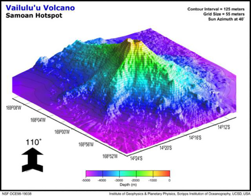 |
Figure 3. Perspective view of Vailulu'u seamount looking NW, displaying three major rifts toward the E, SE, and W. The lower slopes of Vailulu'u and Ta'u merge along the western ridge, with a saddle at 3,200 m. Vailulu'u is ~ 35 km in diameter at its base. Scale: 10' = 18 km. From Hart and others (2000). |
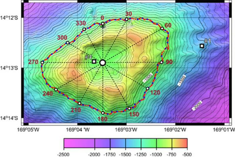 |
Figure 4. SeaBeam bathymetry map of the summit crater of Vailulu'u, showing the crater rim with three peaks and three breaches, the location of CTDO (conductivity, temperature, depth, optical) casts 1 and 4, and the tow-yo track circumnavigated around the summit. Dotted azimuth lines are given every 30° along the track. Scale: 1' = 1.8 km. From Hart and others (2000). |
The overall shape of Vailulu'u is dominated by two rift zones extending E and W from the summit, defining a lineament parallel to the Samoan hotspot track. A third, slightly less well-developed rift extends SE from the summit, and several minor ridges extend out from the lower slopes, making an overall asymmetric, star-like pattern. Rift zones and ridges in the southern sector are more strongly developed than those on the N flank, giving Vailulu'u a stunning similarity to a juvenile Ta'u island (figure 2). The three major rift zones define three high points of the crater rim. The crater and rim are oval-shaped (figure 3), with two well-developed pit craters defining the northern two-thirds of the crater and two minor depressions on a bench in the southern third of the crater.
Several historical events suggest volcanic activity. There was a series of acoustically detected explosions on 10 July 1973 (Johnson, 1984), and during 9-29 January 1995 the global seismic network recorded a strong (M 4.2-4.9) earthquake swarm in the vicinity (BGVN 20:01 and 20:02). While most of the 1995 earthquakes were formally located NW of the volcano, their uncertainty ellipses include Vailulu'u; a SeaBeam survey within the apparent earthquake area did not reveal any volcano-tectonic features. Dredges, especially those from the summit area, are dominated by fresh volcanic rock, with pristine volcanic glass, many original glassy surfaces, unaltered olivine phenocrysts, and a virtual lack of vesicle fillings. Extremely "bright" SeaBeam sidescan returns suggest that fresh volcanic rocks occur ubiquitously throughout the slopes of Vailulu'u and that sediment cover is largely absent.
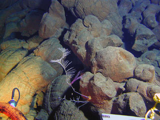
A detailed nephelometry survey of the water column shows clear evidence for hydrothermal plume activity in the summit crater. The water inside the crater is very turbid, and a halo of "smog" several hundred meters thick encircles and extends away from the summit for at least 7 km (see Hart and others, 2000, for details).
During the DeepFreeze 2000 cruise in March 2000, aboard the U.S. Coast Guard Icebreaker Polar Star, conductivity temperature depth optical (CTDO)/Niskin stations were occupied at three places within the summit crater and two outside the crater; in addition, the summit area was circumnavigated in tow-yo mode along the ~1,000-m contour (figure 4). Particulate distribution in the water column was studied using a light backscattering sensor (LBSS) attached to a CTD/Niskin water sampling rosette. At 600-m depth in the crater turbidity increased sharply and continued to do so in a stepwise fashion to the bottom of the crater at 996 m. Turbidity near the bottom was greater than that associated with active venting and plume formation on ridge crests. At station 1, outside the crater, the LBSS "smog" layer starts at about the same depth (610 m) but returns to background values at 850 m. This depth interval is comparable to the elevation range of the crater rim, which has peaks at 590 m and a deepest breach at ~780 m (figure 4). At station 5, 7.5 km E of the crater rim, a small turbidity anomaly was observed at a depth of 600-720 m.
During a complete 360° circumnavigation of the summit crater, the plume was mapped from 500 to 900 m depth in tow-yo mode (figure 4). Overall, the hydrothermal plume was confined to a narrow depth interval bracketed between the breaches and summits of the crater wall. Its upper, neutral buoyancy, level corresponds closely with the heights of the peaks on the crater rim. Virtually no particulate matter appears to be ejected from the crater to heights above the peaks on the crater rim nor does any settle below the breach depth during its dispersion laterally away from the summit. Particulates are being generated within the crater and are subsequently carried away by ocean currents.
Vailulu'u is clearly a young and active submarine volcano. Its activity is reflected in acoustic/seismic events in 1973 and 1995, the lack of any sediment cover, fresh basalt and pristine glass in dredges from all levels, and radiometric ages ranging from 5 to 50 years. The summit is marked by a sharply delineated crater over 400 m deep, filled with highly turbid water. This smog layer extends out as a halo for many kilometers in all directions, in a narrow depth interval defined by the range in depths of the rim of the summit crater.
During another cruise to Vailulu'u in April 2001, on the USCG Icebreaker Polar Sea, Hart and colleagues retrieved five hydrophones and temperature loggers that had been deployed the year before. A lot of minor seismic activity was still occurring, but detailed analyses have not been completed. The crater was still full of "smog," indicating that the crater remains hydrothermally active.
Previous work by Rockne Johnson. This seamount was discovered on 18 October 1975 by Rockne Johnson (Johnson, 1984) using an echosounder and a proton magnetometer aboard the 19-m ketch Kawamee while searching for the source of explosions detected on 10 July 1973. Those explosions, 26 within a 30-minute period, were identified in records from SOFAR (sound-fixing and ranging) stations at Wake and Midway Islands. The signals were calculated to have been from a source along a line that fell 15 km E of Ta'u Island, and were distinct from signals recorded a few hours later caused by a submarine eruption south of Curacao Reef 500 km W at the north end of the Tonga Ridge (CSLP Cards 1679, 1685, and 1694). Depths near 600 m were found around the summit, and a large magnetic anomaly was centered 4 km NW of the summit. Johnson (1984) believed that the seamount, which he named "Rockne Volcano," was the most likely source for the July 1973 activity, but noted that there was some doubt because of its distance from the line of position calculated from the acoustic data.
Selection of a volcano name. As reported by the Samoa News, the Samoa Department of Education's Science Department held a "Name that Volcano" contest in the high schools to come up with a permanent name for this volcano. Previously the volcano had been catalogued as "Unnamed" (Simkin and Siebert, 1994), and named "Rockne" (Johnson, 1984) and "Fa'afafine" (Hart and others, 1999). Woods Hole Oceanographic Institution scientist Stan Hart urged that the name endorsed by American Samoa be adopted by the scientific community. The winning entry, announced on 8 May 2000, came from Taulealo Vaofusi, a sophomore at Samoana High School. "Because of the location of the volcano being very close to the Manu'a Islands village of Ta'u," Vaofusi explained to the Samoa News, "I would like to rename that volcano 'Vailulu'u Volcano.' According to legend, Vailulu'u was the sacred sprinkling of gentle rain that fell just before the gatherings of the great King Tuimanu'a. The Manu'a group is also call the sacred islands or the Motu Sa, and the name 'Vailulu'u' is given to the fountain owned by King Tuimanu'a," said Vaofusi in his entry form.
References. Hart, S.R., Staudigel, H., Koppers, A.A.P, Blusztajn, J., Baker, E.T., Workman, R., Jackson, M., Hauri, E., Kurz, M., Sims, K., Fornari, D., Saal., A., and Lyons, S., 2000, Vailulu'u undersea volcano: The New Samoa: Geochemistry, Geophysics, Geosystems (G3), American Geophysical Union, v. 1, December 8, 2000.
Hart, S.R., Staudigel, H., Kurz, M.D., Blusztajn, J., Workman, R., Saal, A., Koppers, A., Hauri, E.H., and Lyons, S., 1999, Fa'afafine volcano: The active Samoan hotspot: EOS Transactions, American Geophysical Union, v. 80, 1999 Fall Meeting Supplement, p. F1102.
Johnson, R.H., 1984, Exploration of three submarine volcanos in the South Pacific: National Geographic Society Research Reports, National Geographic Society, v. 16, p. 405-420.
Simkin, T., and Siebert, L., 1994, Volcanoes of the World, 2nd edition: Geoscience Press in association with the Smithsonian Institution Global Volcanism Program, Tucson AZ, 368 p.
Smith, W.H.F., and Sandwell, D., 1996, Predicted bathymetry, new global seafloor topography from satellite altimetry: EOS Transactions, American Geophysical Union, v. 77, no. 46, p. 315.
Stice, G.D., and McCoy, F.W., Jr., 1968, The geology of the Manu'a Islands, Samoa: Pacific Science, v. 22, p. 427-457.
Geological Summary. Vailulu'u, a massive basaltic seamount discovered in 1975, rises 4,200 m from the sea floor to a depth of 590 m. Located about one-third of the way between Ta'u and Rose islands at the E end of the American Samoas, it is considered to mark the current location of the Samoan hotspot. The summit contains an oval-shaped crater that is 2 km wide and 400 m deep. Two principal rift zones extend E and W from the summit, parallel to the trend of the hotspot; a third rift extends SE. The rift zones and escarpments produced by mass wasting phenomena give the seamount a star-shaped pattern. On 10 July 1973 explosions were recorded by SOFAR (hydrophone records of underwater acoustic signals). An earthquake swarm in 1995 may have been related to an eruption. Eruptive activity between April 2001 and April 2005 formed a cone almost 300 m high, named Nafanua. Repeated bathymetric mapping surveys showed depth changes, including height and width increases of Nafanua after 2005, that suggest at least intermittent activity during 1999-2017; a 2019 survey showed no further changes since 2017.
Information Contacts: Stanley R. Hart, Woods Hole Oceanographic Institution, Woods Hole, MA 02543 USA (URL: http://www.whoi.edu/); Samoa News, P.O. Box 909, Pago Pago, AS 96799 (URL: http://www.samoanews.com/).