Report on Lamington (Papua New Guinea) — June 2001
Bulletin of the Global Volcanism Network, vol. 26, no. 6 (June 2001)
Managing Editor: Richard Wunderman.
Lamington (Papua New Guinea) Big eruption's 50th anniversary passed amid continued slumber
Please cite this report as:
Global Volcanism Program, 2001. Report on Lamington (Papua New Guinea) (Wunderman, R., ed.). Bulletin of the Global Volcanism Network, 26:6. Smithsonian Institution. https://doi.org/10.5479/si.GVP.BGVN200106-253010
Lamington
Papua New Guinea
8.95°S, 148.15°E; summit elev. 1680 m
All times are local (unless otherwise noted)
The instrumented, yet now-quiet Mount Lamington resides on the SE peninsula of the main island of Papua New Guinea. It lies roughly across that peninsula from the capital city of Port Moresby and 40 km inland from the Solomon Sea. Lamington's summit contains ragged peaks and a U-shaped crater open to the N. The volcano is ~21 km SSW of Popondetta Town, the provincial center for Oro Province. Lamington does not erupt frequently like Manam and Ulawun, but had a single historical eruption of such magnitude that, if repeated, could be catastrophic for the more than 30,000 people who live nearby.
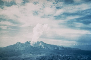
About fifty years ago, on 21 January 1951, a major explosive eruption at Lamington killed ~3,000 people, the most of all historical volcanic eruptions in Papua New Guinea. Before the 1951 eruption, Lamington was not known to be a volcano. The group of mountains where the volcano stands was covered in thick jungle and there were no stories to suggest that eruptions had occurred before. As documented in a classic study by Taylor (1958), the paroxysmal eruption was not a sudden happening, but had begun several days earlier when nearby residents started to see changes in the summit area. The pyroclastic flow from the eruption devastated an area of ~200 km2, forming a radial pattern around the volcano that extended slightly farther on the N side. Two photos illustrating aspects of the eruption appear in figures 1 and 2. One of the hallmarks of Taylor's study was his well-developed timelines that clearly stated the sequence of events.
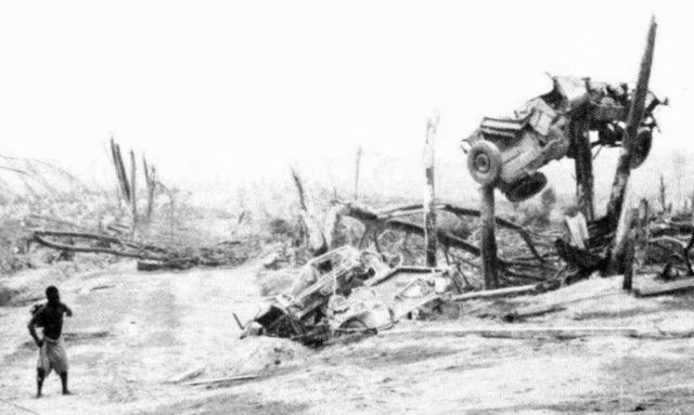 |
Figure 1. In an area devastated by a Lamington nuée ardente (pyroclastic flow) on 21 January 1951; this motor vehicle was left suspended in two truncated trees. The person shown for scale is staff member Leslie ToPue, who worked at RVO until 1992. The spot shown lies on the N flank, 9-10 km from the summit dome (in the N end of the settlement of Higaturu), an area directly in front of the summit crater's prominent opening. This photo is cropped from one included in Taylor (1958, 1983) as his figure 69 (page 56). Courtesy of RVO. |
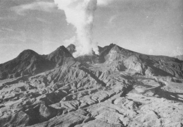 |
Figure 2. Photograph of Lamington taken on 8 February 1951 looking northward into the summit crater's prominent opening and onto the adjacent area immediately downslope of the crater, called Avalanche Valley. The crater contains the steaming dome that grew after the paroxysmal eruption. The mid- to fore-ground shows the ash-mantled NNE slopes (the subject of most of this part of the photo) and mudflow deposits (dark zones, sweeping across limited areas in the right center). This photo came from Taylor (1958, 1983 figure 118 on page 84). |
Hastily arranged monitoring commenced immediately after the 1951 eruption but only operated during the active phase of the eruption. A more permanent monitoring program began in 1970 with the installation of a seismograph. In October 1996, a modern seismic station and an electronic tiltmeter were installed on Lamington.
Currently RVO has permanent, smaller observatories at Lamington, as well as at Ulawun, Langila, Karkar, Manam, and Esa'ala. Each is equipped with a recording seismograph. In addition, the stations at Lamington, Ulawun, Karkar, and Manam contain real-time high-frequency data-transmission systems that allow RVO volcanologists to remotely monitor those sites.
Since the 1951 eruption, seismic activity has been absent to rare. Seismic records on 21 December 2000 and 17 February 2001 showed several hours of very high seismicity, but it was difficult to ascertain the cause.
Reference. Taylor, G.A.M., 1958 (2nd ed., 1983), The 1951 eruption of Mount Lamington, Papua: BMR (Australia) Bulletin 38, Australian Government publishing service, Canberra (ISBN 0 644 01969 7; ISSN 0084-7089).
Geological Summary. Lamington is an andesitic stratovolcano with a 1.3-km-wide breached summit crater containing a lava dome that rises above the coastal plain of the Papuan Peninsula of New Guinea north of the Owen Stanley Range. A summit complex of lava domes and crater remnants tops a low-angle base of volcaniclastic deposits dissected by radial valleys. A prominent broad "avalanche valley" extends northward from the breached crater. Ash layers from two early Holocene eruptions have been identified. In 1951 a powerful explosive eruption produced pyroclastic flows and surges that swept all sides of the volcano, killing nearly 3,000 people. The eruption concluded with growth of a 560-m-high lava dome in the summit crater.
Information Contacts: Ima Itikarai, Rabaul Volcano Observatory (RVO), P.O. Box 386, Rabaul, Papua New Guinea.