Report on Kilauea (United States) — September 2001

Bulletin of the Global Volcanism Network, vol. 26, no. 9 (September 2001)
Managing Editor: Richard Wunderman.
Kilauea (United States) Branching lava flows, ocean entries, and elevated seismicity into September 2001
Please cite this report as:
Global Volcanism Program, 2001. Report on Kilauea (United States) (Wunderman, R., ed.). Bulletin of the Global Volcanism Network, 26:9. Smithsonian Institution. https://doi.org/10.5479/si.GVP.BGVN200109-332010
Kilauea
United States
19.421°N, 155.287°W; summit elev. 1222 m
All times are local (unless otherwise noted)
Throughout this reporting interval, December 2000-September 2001, volcanic tremor near Pu`u `O`o and in Kīlauea's caldera remained low to moderate. Tiltmeters in the summit area and along the E rift zone showed no deformation. Branching lava flows, occasional sea entries of lava, and several seismic events took place. Small-to-moderate steam plumes originating at the ocean entries were visible on 10 December, on 5, 7, 26, and 30 May, and on 13 June. On 14 August a large steam plume was visible. Sulfur dioxide output from the Pu`u `O`o area was high on 15 May.
Lava flows. Beginning on 17 December 2000, lava moved down the Pulama Pali slope and across the coastal flat, along E, W, and middle branches, through a combination of tubes and surface flows (figure 151).
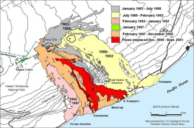 |
Figure 151. Map showing lava flows erupted during Kīlauea's 1983 to 30 September 2001 activity. The flows active from 17 December 2000 through 30 September 2001 appear in dark gray. Note the strand-like W flow shown extending several kilometers in length and entering the sea at Kamoamoa. Courtesy of HVO. |
Lava frequently broke out of the tube system beginning in January and February 2001. One breakout on 23 February along the E side of the flow field at the private access road to the Royal Gardens subdivision was quite substantial; a house in Royal Gardens was destroyed and an abandoned car was half-submerged in lava in front of it.
By mid-March the leading edge of the 1.5-m-wide flow front was within about 300 m of the coastline, headed for the sea E of Kupapa'u Point. During the end of March, activity was robust near the truncated road that formerly accessed Royal Gardens. In that area, surface flows occurred at dozens of points and rapidly inflated. Ground observers reported hearing methane explosions from burning vegetation along the base of the Pulama Pali slope.
During early April 2001, surface activity was confined to a small sluggish flow in the E branch of the flow field; most of the lava was encased in tubes and thus not flowing on the surface. At midday on 29 April, a tongue of lava began to pour into a crack paralleling the shoreline that separated a narrow sea cliff from stable ground inland. Eventually the lava wedged the crack open so much that the unstable block of land fell into the water, generating an explosion that tossed rocks onto dry land.
On 13 May, the active flow was 300-500 m from the nearest house in the Royal Gardens subdivision, but the homes were protected from the lava by a barrier of aa deposited in 1983. On 3 September, a lava flow, ~3.6-5.5 m wide, crossed the viewing-access road W of Kalapana, isolating the viewing area. The road, which was opened on 17 August, was closed on 30 August after about 10,000 visitors had used it over the previous two weeks. The flow across the access road stopped on 5 September, and road crews prepared to reopen it.
Ocean entry. Lava entered the sea on several occasions during this report period. The W arm of the coastal flow reached the sea in late December 2000 then quickly stagnated, remaining barely active as late as September 2001. During 21-29 January 2001 lava entered the sea just W of Kamokuna, and during 25-29 April lava entered the sea a few hundred meters NE of Kupapa`u Point, developing a large bench at the E Kupapa`u entry site.
On the afternoon of 13 May observers found three ocean-entry benches along the SE corner of the active flow field, NE of Kupaupau Point and 120-790 m outside the national park. The benches increased in area and width eastward, from 10 m wide near the boundary to nearly 60 m wide at the eastern bench. The eastern bench was 2 hectares in area, was the most active, and nearly coalesced with the middle bench. Sand beaches 10-15 m wide filled the gaps between the benches. Vigorous venting of lava into the sea occurred at the SE corner of the active flow field during the evening of 13 May.
Lava entered the ocean on several other occasions, including 20 and 31 May, and 2 and 18 June, mostly through the E Kupapa`u entry (figure 152). By 22 May, only the ocean entry at the SE corner of the flow field was active, indicating that lava was still coursing through the system but was confined to tubes for at least most of the way from Pu`u `O`o to the sea. Ocean entry at E Kupapa`u was fairly vigorous during the evening of 14 August, with a large steam plume, an open lava river pouring into the sea, and numerous mild-to-moderate steam explosions.
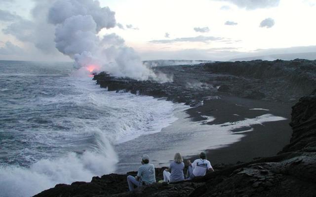 |
Figure 152. Kīlauea view from E of E Kupapa`u ocean entry at dusk on 10 July 2001. The bench was comparatively large, reaching out about 120 m from the sea cliff. Note the new black sand beach formed by deposition of glass created when lava enters the sea. Courtesy of HVO. |
Geophysical activity. During 1500-2400 on 6 January 2001, deflation events occurred at Kīlauea's summit and at Pu`u `O`o, amounting to ~1.7 µrad and ~2.8 µrad, respectively. The intensity of volcanic tremor increased beneath Kīlauea's caldera around the same time, though the tremor remained low-to-moderate in strength.
At about 0625 on 7 January, the tiltmeter near the observatory began to show very rapid inflation, jumping up to ~1.4 µrad in 32 minutes and eventually peaking at ~2.6 µrad by 1323. The sharpest inflation was accompanied by nearly 30 minutes of increased tremor beneath Kīlauea's caldera-even above that caused by the deflation event the previous day. By 8 January tilt and seismicity at the summit and Pu`u `O`o appeared to have returned to background levels. On the morning of 11 January, a burst of strong tremor in the caldera lasted about 30 minutes.
A small (~0.4 µrad) deflation occurred shortly before 1230 on 10 February. A weak swarm of shallow earthquakes within the caldera on 18-19 February ended by 20 February. On 20 February at 1317 a M 3.7 earthquake in the summit area was centered ~5 km SE of Halemaumau at a very shallow depth.
A swarm of earthquakes on the NE flank of Mauna Kea occurred during 22-24 February. The earthquakes in the swarm were all about M 3 and came from depths of 2-12 km. During early to mid-March, small low-frequency earthquakes took place below the caldera.
On 7 April tiltmeters recorded a summit deflation up to ~3 µrad. The deflation ended in early afternoon, but the heightened tremor below the caldera continued. The tilt record at Pu`u `O`o cone suggested that it began to deflate on the morning of 6 April at about 0600, stabilized in the afternoon, and started to inflate the morning of 7 April shortly after 0400. This inflation may have eventually led to later eruptive activity on the crater floor.
By 8 April the tiltmeter had recovered ~1.4 µrad and was increasing. Tremor below Kīlauea's caldera was nearly at background levels. Starting at about 0200 on the morning of 8 April, the summit began to inflate. By about 0300, the amplitude of tremor and the rate of long-period earthquakes began to decline to nearly background levels. Summit tilt leveled out at about 1000, regaining 2.5 µrad of the 3 µrad lost during the deflation that occurred on 7 April.
A slight deformation of the summit occurred during 23-25 April. In the afternoon of 25 April, a M 4.4 earthquake occurred near the observatory that produced a few small aftershocks during the following week. A swarm of long-period (LP) earthquakes that began beneath Kīlauea's caldera on 18 April had nearly ended by 2 May.
Volcanic tremor was higher than normal during 12 and 13 May and small earthquakes were recorded in the caldera. During mid-May, earthquake activity and volcanic tremor near Pu`u `O`o and in Kīlauea's caldera were at moderate levels with periods of rather strong ground motion.
On the afternoon of 20 May the largest tilt event to occur at Kīlauea in more than 4 years took place. Beginning at 0500 the summit began to slowly deflate (~2 µrad) until about 1630 when it very abruptly began to inflate (~10 µrad). It peaked at 1735 and began to deflate at 1750. The tiltmeter on the cone of Pu`u `O`o, and another one nearby, both recorded sharp inflation starting at about 1650, approximately 20 minutes later than the start of tilt at Kīlauea's summit.
At about 1920, a lava pond was observed to be forming in the crater of Pu`u `O`o. The surface lava flows showed no boost from the inflation. Instead, observations on 21 May revealed that the pond had drained.
No earthquakes were felt during the tilt event and no lava erupted in the caldera. The event was accompanied by strong tremor, which ended a prolonged period of small earthquakes in the caldera that had lasted, with a 9-hour break on the night of 18 May, for several days. Small earthquakes of the LP type, suggestive of magma movement, began again in the caldera and gradually increased from 21 to 22 May to a reasonable swarm. The tilt event ended on 22 May, as Kīlauea lost most of the positive tilt it had acquired.
Summit tilt started to rise on the afternoon of 22 May at a moderately rapid pace but slowed the morning of 23 May. Pu`u `O`o cone showed some inflation.
On 3 June a pause in volcanic activity may have begun at about 0900 with slow deflation (~2.6 µrad) occurring at the tiltmeter closest to HVO. It ended around 2400 and at 0125 rapid inflation (~2.7 µrad) began with most of the inflation occurring in about 55 minutes. Slow deflation (0.9 µrad) occurred at Pu`u `O`o during 1015-2200 on 3 June, with slow inflation occurring to at least 4 June. Background volcanic tremor at the summit gradually increased starting in mid-morning on 3 June, after deflation had begun. There was no significant change in the tremor at Pu`u `O`o.
Generally weak, steady tremor and related long-period earthquakes continued beneath Kīlauea's caldera throughout June. There was a slight increase in long-period caldera earthquakes for several hours on 18 June. Tremor remained weak to moderate near Pu`u `O`o and seismicity was at normal levels elsewhere. On 26 June from about noon until the evening a small amount of deflation occurred at the summit and ~0.5 µrad at Pu`u `O`o cone.
An earthquake with a preliminary magnitude of 3.5 rattled through the lower E rift zone of Kīlauea the evening of 16 July at about 1803. Located about halfway between Pahoa and Kapho, the earthquake was shallow (about 1.5 km deep) and felt locally by many residents. A swarm of earthquakes began on 21 July and ended by 25 July. Weak tremor began on 30 July near Pu`u `O`o.
Tremor near Pu`u `O`o was weak- to-moderate during August. During the afternoon of 15 August the intensity of volcanic tremor increased abruptly at both Kīlauea's summit and Pu`u `O`o but remained only moderate to low.
On 25 August a small but sharp inflation of Kīlauea's summit took place in the morning, amounting to slightly more than 1 µrad. The inflation began a little after 1000 and followed several hours of slow deflation. The inflation was mostly completed by noon, having recovered most of the tilt lost during the deflation. Pu`u `O`o cone underwent a very sharp inflation ~1 hour before the summit began to inflate and, just as at the summit, the inflation of the cone followed several hours of slow deflation. No upswing in seismicity accompanied the ground tilts. Small sharp earthquakes from beneath the summit continued but remained infrequent. As of early September, Kīlauea's summit was deflating very slowly.
Lava flow . A summary of statistics of the Pu`u `O`o- Kupaianaha eruption is provided in table 5. Since the start of the eruption in 1983, lava has covered 104 km2, which is just over 7% of Kīlauea's land surface. Some areas mantled repeatedly and are now buried beneath more than 30 m of basalt. Kīlauea's surface is comparatively young: ~70% is paved with flows younger than 600 years; 90% is younger than 1,100 years.
Table 5. Summary of statistics for the Pu`u `O`o-Kupaianaha eruption as of the end of the year 2000. Courtesy of HVO.
| Description | Statistics |
| Area covered by lava flows during January 1983-31 December 2000 | 104 km2 (40 square miles) |
| Net area of new land created along the coastal margin during November 1986-31 December 2000 | 207 hectares (510 acres) |
| Net area of new land created along the coastal margin during 2000 only | ~7.5 hectares (18.5 acres) |
| Volume of lava erupted during 1983-2001 | 2 km3 (0.5 cubic miles) |
| Structures destroyed during 1983-1991 | 184 |
| Structures destroyed during 2000 | 3 (all in Royal Gardens) |
An eruption during the 14th century was fed from a vent just E of the summit area and probably continued discharging for about 50 years. Flows from this eruption covered a very large area N of the E rift zone, about 430 km2 (30 percent of Kīlauea's land surface). The 2-year-long Mauna Ulu eruptions (1969-71 and 1972-74) covered about 50 km2 and 44 km2, respectively.
Geological Summary. Kilauea overlaps the E flank of the massive Mauna Loa shield volcano in the island of Hawaii. Eruptions are prominent in Polynesian legends; written documentation since 1820 records frequent summit and flank lava flow eruptions interspersed with periods of long-term lava lake activity at Halemaumau crater in the summit caldera until 1924. The 3 x 5 km caldera was formed in several stages about 1,500 years ago and during the 18th century; eruptions have also originated from the lengthy East and Southwest rift zones, which extend to the ocean in both directions. About 90% of the surface of the basaltic shield volcano is formed of lava flows less than about 1,100 years old; 70% of the surface is younger than 600 years. The long-term eruption from the East rift zone between 1983 and 2018 produced lava flows covering more than 100 km2, destroyed hundreds of houses, and added new coastline.
Information Contacts: Hawaiian Volcano Observatory (HVO), U.S. Geological Survey, PO Box 51, Hawaii National Park, HI 96718, USA (URL: https://volcanoes.usgs.gov/observatories/hvo/).