Report on Yasur (Vanuatu) — November 2001

Bulletin of the Global Volcanism Network, vol. 26, no. 11 (November 2001)
Managing Editor: Richard Wunderman.
Yasur (Vanuatu) Still erupting despite 10-fold tremor decrease beginning November 1999
Please cite this report as:
Global Volcanism Program, 2001. Report on Yasur (Vanuatu) (Wunderman, R., ed.). Bulletin of the Global Volcanism Network, 26:11. Smithsonian Institution. https://doi.org/10.5479/si.GVP.BGVN200111-257100
Yasur
Vanuatu
19.532°S, 169.447°E; summit elev. 361 m
All times are local (unless otherwise noted)
Since the end of Yasur's recent very active period during June-November 1999 (BGVN 24:07), volcanic tremor underwent an abrupt drop (figure 23). IRD seismologists define tremor amplitudes at "level 3" for signals 12-60 um and "level 4" for signals over 60 um. As figure 23 shows, the number of tremors at level 3 recorded between January 2000 and November 2001 was ten-times lower than that recorded each year between 1995 and 1998. In that same 22-month period, only a few dozen seismic events of over 60 µm amplitude were recorded (BGVN 24:04).
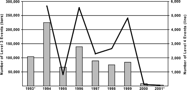 |
Figure 23. Tremor recorded at Yasur during late January 1993 through November 2001. Bars relate to the left-hand scale and show the yearly number of level 3 events (amplitudes of 12-60 µm). Points connected by lines relate to the right-hand scale and show the yearly number of level 4 events (amplitudes over 60 µm). Asterisks indicate years with incomplete data, as follows: (a) for 1993, only level 3 data were available for the entire year; and (b) the 2001 data shown only extends through 1 November 2001. Courtesy Michel Lardy, Janette Tabbagh, Douglas Charley, and Sandrine Wallez. |
The eruptive activity observed at vent A, in the southern part of the crater (figures 24, 25, and 26), shifted following a violent event that affected the northern part of the crater at areas B and C in October 1999. Since this event, the explosive activity has remained mild, and limited to vent C, the northernmost vent of the crater.
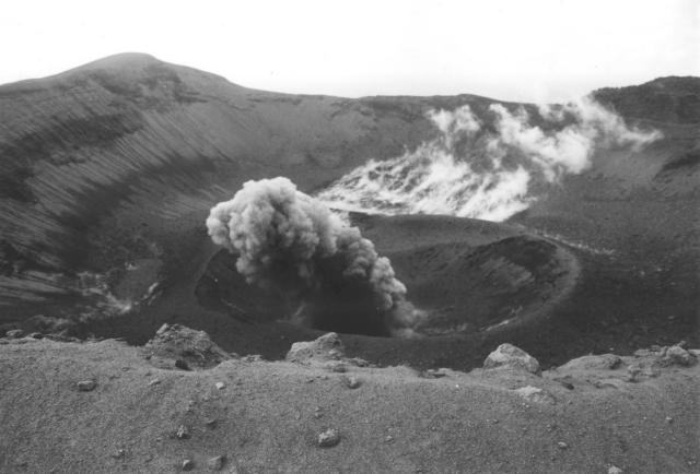 |
Figure 24. A view of the crater of Yasur on 2 October 1999, taken facing N while on the southern edge. Copyrighted photo courtesy of Michel Lardy, IRD. |
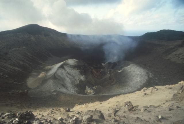 |
Figure 25. A view of the crater of Yasur on 9 September 2001, taken facing N while on the southern edge. Copyrighted photo courtesy of Michel Lardy, IRD. |
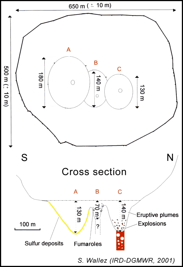 |
Figure 26. A September 2001 visit to Yasur's summit craters with GPS and laser telemetry resulted in this sketch map and N-S cross section. Courtesy of Douglas Charley and Sandrine Wallez (Vanuatu Department of Geology, Mines and Water Resources), and Michel Lardy (IRD). |
A comparison of photographs taken from the southern crater rim in October 1999 (figure 24) and in September 2001 (figure 25) revealed no profound difference in crater morphology. However, during September 2001 vents A and B were plugged and only vent C was active, with ejecta being sent 170 m above the bottom of the crater.
During September 2001, Douglas Charley, Michel Lardy, and Sandrine Wallez undertook a detailed survey of the craters. They used GPS positioning and laser telemetry to produce a map and cross-section showing crater topography and nomenclature (figure 26).
Observations on 12 October 2000. Jeff and Raine Williams, sailing aboard the S/Y Gryphon, visited Yasur on 12 October 2000. From ~8 km away a thick plume of steam and smoke could be seen rising from the peak. The route carried the visitors close to the base of the volcano and across the ash plain that stretches for nearly 1.5 km in each direction from the N flank of the mountain. A narrow stream cuts through the plain at its lowest point, and until recently a freshwater lake had filled the lower basin. Heavy rains earlier in the year resulted in the destruction of the lake's natural dam and left eroded ravines. Their guide drove up through the jungle to the steepest part of the unvegetated cinder cone. From there they hiked ~400 m to the crater rim, a ridge with a sheer 90-120 m drop to the crater floor. Only one of the crater pits was active, producing a constant pillar of steam and smoke. Occasionally the wind would blow strong enough to clear the crater floor, allowing views of the lava glow. Every five or ten minutes the volcano would "cough" or "bark" while throwing red-hot cinders hundreds of feet in the air, tracing red arcs back to the sides of the crater where they glowed for several more minutes. One explosion sent ejecta as high as the rim, but away from the observers. As night fell, red light from the crater was illuminating the pit and the rising steam.
Geological Summary. Yasur has exhibited essentially continuous Strombolian and Vulcanian activity at least since Captain Cook observed ash eruptions in 1774. This style of activity may have continued for the past 800 years. Located at the SE tip of Tanna Island in Vanuatu, this pyroclastic cone has a nearly circular, 400-m-wide summit crater. The active cone is largely contained within the small Yenkahe caldera, and is the youngest of a group of Holocene volcanic centers constructed over the down-dropped NE flank of the Pleistocene Tukosmeru volcano. The Yenkahe horst is located within the Siwi ring fracture, a 4-km-wide open feature associated with eruption of the andesitic Siwi pyroclastic sequence. Active tectonism along the Yenkahe horst accompanying eruptions has raised Port Resolution harbor more than 20 m during the past century.
Information Contacts: Janette Tabbagh, Université Paris VI, UMR 7619, Coordination des recherches Volcanologiques (CRV), 4 Place Jussieu, 75252 Paris Cedex 05, France; Michel Lardy, Institut de Recherche pour le développement (IRD), CRV, BP A 5 Nouméa, Nouvelle Calédonie; Sandrine Wallez and Douglas Charley, Department of Geology, Mines and Water Resources, PMB 01, Port-Vila, Vanuatu; Jeff and Raine Williams, P.O. Box 729, Funkstown, MD 21734, USA.