Report on Avachinsky (Russia) — November 2001
Bulletin of the Global Volcanism Network, vol. 26, no. 11 (November 2001)
Managing Editor: Richard Wunderman.
Avachinsky (Russia) Modest October steam plumes reach 10 km long; minor ash eruption 5 October
Please cite this report as:
Global Volcanism Program, 2001. Report on Avachinsky (Russia) (Wunderman, R., ed.). Bulletin of the Global Volcanism Network, 26:11. Smithsonian Institution. https://doi.org/10.5479/si.GVP.BGVN200111-300100
Avachinsky
Russia
53.256°N, 158.836°E; summit elev. 2717 m
All times are local (unless otherwise noted)
Seismic activity increased at Avachinsky during early December 1998 (BGVN 23:11). After that, seismicity stayed mostly at background levels until 25 August 2001, when it increased slightly, and was variable through at least October.
On 31 August, three earthquakes were registered, M 1.7, 2.2, and 2.6. On 20 September an M 1.7 earthquake occurred. On 21 September from 1705 until 1721, a series of earthquakes within the volcano's edifice was recorded, including an M 2.5 event at a depth of ~4 km. On 22 September at 0500 UTC, a 3-pixel thermal anomaly was clearly seen in an AVHRR image of Avachinsky.
At 0750 on 5 October, with an accompanying M 1.5 earthquake, a small explosion lofted ash to less than 1 km above the crater with minor ash falling on the SE flank. Around 19 October a series of weak local earthquakes (~ 50 events of M 0.5-1.5) was registered within 24 hours in the edifice at a depth of ~700 m beneath the summit.
Weak fumarolic activity was observed during 20, 23, 26, and 28 September, and 2-4, 10, 11, 16, and 17 October. In contrast, on 6 October fumarolic activity was observed over the entire crater. Small mudflows down the SE flank were visible in late September after every snowfall, presumably due to strong thermal activity of a fumarole on the SE crater rim. Gas-and-steam plumes were observed several times during September and October 2001 (figure 2 and table 1) when clouds did not obscure the volcano.
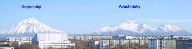 |
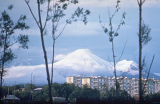
Figure 2. Avachinsky (summit elevation, 2,741 m) and Koryaksky (3,456 m) stratovolcanoes as seen from the city of Petropavlovsk on 13 October 2001. They reside 35-40 km NE of the city and their summits are separated by 12 km. A white plume is extending E from Avachinsky. Courtesy of KVERT. |
Table 1. Gas-and-steam plumes reported at Avachinsky during September and October 2001. Courtesy KVERT.
| Date | Time | Plume height / location |
| 19 Sep 2001 | -- | 30 m above crater. |
| 06 Oct 2001 | 1250 | Low over crater, extending 10 km SE. |
| 07 Oct 2001 | 0850 | Rising 50 m over the crater and extending SSE. |
| 07 Oct 2001 | 1700 | Rising 200 m above crater. |
| 09 Oct 2001 | -- | Rising low above crater, extending 5 km E. |
| 11 Oct 2001 | 0940 | Rising 200 m and extending 5 km E. |
| 12 Oct 2001 | 2000 | Rising over the crater and extending 1 km E. |
| 13 Oct 2001 | 1130 | Extending 10 km E. |
| 13 Oct 2001 | 2000 | Extending 10 km E. |
| 20 Oct 2001 | 1430-1930 | Rising ~1 km above the crater; extending 20 km SE. |
| 21-22 Oct 2001 | -- | Rising 50-200 m above the crater and extending SE, E, and NE. |
A band-6 satellite image on 2 October showed a broad area of warm ground that appeared to follow the rim of the crater, with a small area in the center of the crater. Band-7 data on 2 October showed hotter areas in the SE and SW parts of the crater, and possibly on the N side. On 5 October, the Concern Color Code was increased from Green (volcano is dormant; normal seismicity and fumarolic activity) to Yellow (volcano is restless; eruption may occur). A large, elongate cloud was recorded extending to the SE from the volcano at 1830 on 8 October.
The last explosive eruption at Avachinsky occurred in 1991 and lasted 6 days. The eruption began with two ash explosions directed SW toward Petropavlovsk, and covered the town with an ash layer a few millimeters thick. Effusion of lava began 28 hours later. Further explosive activity occurred simultaneously with the lava emission. As a result of the eruption, a lava plug filled the entire crater.
The Kamchatka Volcanic Eruptions Response Team (KVERT) speculated that the recent activity at Avachinsky could indicate the occurrence of a scenario similar to the eruptions in the years 1737 and 1827. Present activity could lead to a large eruption accompanied by directed blasts with voluminous tephra, debris avalanches, and mudflows. Or, gradual damage of the plug might occur by various means, including earthquakes, small explosive discharges, mudflows, etc. Both scenarios could pose a potential hazard to nearby farm cottages (dachas), the Radyugina settlement, and Petropavlovsk-Kamchatsky city.
Geological Summary. Avachinsky, one of Kamchatka's most active volcanoes, rises above Petropavlovsk, Kamchatka's largest city. It began to form during the middle or late Pleistocene, and is flanked to the SE by Kozelsky volcano, which has a large crater breached to the NE. A large collapse scarp open to the SW was created when a major debris avalanche about 30,000-40,000 years ago buried an area of about 500 km2 to the south, underlying the city of Petropavlovsk. Reconstruction of the volcano took place in two stages, the first of which began about 18,000 years before present (BP), and the second 7,000 years BP. Most eruptions have been explosive, with pyroclastic flows and hot lahars being directed primarily to the SW by the collapse scarp, although there have also been relatively short lava flows. The frequent historical eruptions have been similar in style and magnitude to previous Holocene eruptions.
Information Contacts: Olga Girina and Lilia Bazanov, Kamchatka Volcanic Eruptions Response Team (KVERT), Institute of Volcanic Geology and Geochemistry, Piip Ave. 9, Petropavlovsk-Kamchatsky, 683006, Russia; John C. Eichelberger and Tom Murray, Alaska Volcano Observatory (AVO), a cooperative program of a) U.S. Geological Survey, 4200 University Drive, Anchorage, AK 99508-4667, USA (URL: http://www.avo.alaska. edu/), b) Geophysical Institute, University of Alaska, PO Box 757320, Fairbanks, AK 99775-7320, USA, and c) Alaska Division of Geological & Geophysical Surveys, 794 University Ave., Suite 200, Fairbanks, AK 99709, USA.