Report on Turrialba (Costa Rica) — November 2001
Bulletin of the Global Volcanism Network, vol. 26, no. 11 (November 2001)
Managing Editor: Richard Wunderman.
Turrialba (Costa Rica) Seismic and fumarolic activity during January 2000-August 2001
Please cite this report as:
Global Volcanism Program, 2001. Report on Turrialba (Costa Rica) (Wunderman, R., ed.). Bulletin of the Global Volcanism Network, 26:11. Smithsonian Institution. https://doi.org/10.5479/si.GVP.BGVN200111-345070
Turrialba
Costa Rica
10.025°N, 83.767°W; summit elev. 3340 m
All times are local (unless otherwise noted)
During January 2000 to at least August 2001, seismic and fumarolic activity continued at Turrialba (table 5). On 12 March 2000 an M 3.2 earthquake was registered at a depth of 7 km, 6.5 km E of the active crater. The EDM lines (radial lines of distances) as well as the dry clinometers did not show significant changes during 2000.
Table 5. Summary of earthquakes and fumarolic temperatures at Turrialba during January 2000 to August 2001, registered by a seismograph at station VTU, located ~0.5 km SE of the active crater. Microearthquakes were defined as earthquakes registered on the local seismic system with amplitudes under 15 mm. Missing months indicate that no data was available for that month. NR indicates information not reported. Courtesy of OVSICORI-UNA.
| Month | AB earthquakes | LF earthquakes | Micro-earthquakes | Total earthquakes | Maximum fumarolic temperature (°C) | Comment |
| Jan 2000 | 29 | 2 | 33 | 64 | NR | Seismicity registered only 13 days. |
| Feb 2000 | 91 | -- | 75 | 166 | NR | Seismicity registered only 16 days. |
| Mar 2000 | 44 | -- | 65 | 113 | 91 | -- |
| Apr 2000 | NR | NR | NR | NR | 90 | -- |
| May 2000 | 286 | 5 | 330 | 616 | NR | -- |
| Jul 2000 | 50 | -- | 104 | 167 | 90 | -- |
| Aug 2000 | 76 | -- | 148 | 229 | 89 | -- |
| Sep 2000 | 243 | -- | 244 | 493 | 89 | -- |
| Oct 2000 | NR | NR | NR | NR | 93 | -- |
| Mar 2001 | 399 | 948 | 718 | 2075 | NR | -- |
| May 2001 | 128 | -- | 334 | 464 | 92 | An average of 15 earthquakes per day. |
| Jun 2001 | 3 | -- | 185 | 194 | 92 | Six VT earthquakes. |
| Jul 2001 | 24 | -- | 310 | 334 | 91 | -- |
| Aug 2001 | 14 | -- | 261 | 275 | 90 | -- |
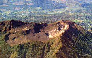
Fumarolic activity was persistent in the N, NW, NE, and E walls of the main crater. Fumarolic activity in the S and SW walls diminished by July 2000 and began to reappear during October 2000. Activity in the N wall during May 2001 was more vigorous than previously. Small landslides persisted in the walls of the main crater, covering some fumaroles at the bottom and revealing other new ones.
During March 2001 sulfur precipitation and gaseous emanations in the internal walls occurred throughout most of the central craters. Gaseous activity also persisted in the W crater walls. During June 2001, a small patch of vegetation at the center of the main crater showed partial burns due to the gas escaping in the NE part of the main crater.
Geological Summary. Turrialba, the easternmost of Costa Rica's Holocene volcanoes, is a large vegetated basaltic-to-dacitic stratovolcano located across a broad saddle NE of Irazú volcano overlooking the city of Cartago. The massive edifice covers an area of 500 km2. Three well-defined craters occur at the upper SW end of a broad 800 x 2200 m summit depression that is breached to the NE. Most activity originated from the summit vent complex, but two pyroclastic cones are located on the SW flank. Five major explosive eruptions have occurred during the past 3500 years. A series of explosive eruptions during the 19th century were sometimes accompanied by pyroclastic flows. Fumarolic activity continues at the central and SW summit craters.
Information Contacts: Observatorio Vulcanologico y Sismologico de Costa Rica, Universidad Nacional (OVSICORI-UNA), Apartado 86-3000, Heredia, Costa Rica.

