Report on Erta Ale (Ethiopia) — December 2001
Bulletin of the Global Volcanism Network, vol. 26, no. 12 (December 2001)
Managing Editor: Richard Wunderman.
Erta Ale (Ethiopia) Dynamic, molten lava lake in S crater during November 2000-February 2001
Please cite this report as:
Global Volcanism Program, 2001. Report on Erta Ale (Ethiopia) (Wunderman, R., ed.). Bulletin of the Global Volcanism Network, 26:12. Smithsonian Institution. https://doi.org/10.5479/si.GVP.BGVN200112-221080
Erta Ale
Ethiopia
13.601°N, 40.666°E; summit elev. 585 m
All times are local (unless otherwise noted)
The Afar National Regional State has approved a program to grant access to Erta Ale volcano by either land or air transportation. The program, which will precede the formation of a "National Park of Volcanoes," enables visitation by natural science field workers. It also allows for traditional mining and salt transportation by caravans and seeks to protect the traditional life of the region's inhabitants.
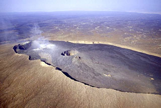
Observations during 14 November 2000. Luigi Cantamessa (Géo-Découverte), accompanied by government representatives, visited the N part of the elliptical summit caldera (figure 7) on 14 November 2000. Little had changed since last described in December 1995 (BGVN 20:11/12), but continued collapse of the N crater wall was noted. Dense smoke came from the S rim of the crater, with a very strong smell of sulfur, as in the past. GPS measurements of elevation indicated that the E wall of the N crater was ~600 m high and the N rim, the highest point of the volcano, was ~15 m higher.
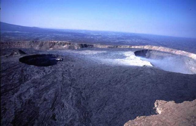 |
Figure 7. Aerial photograph showing the N part of the Erta Ale caldera. In this view looking generally W, the inactive northern crater (with fumarolic emissions) is on the right and the southern crater with an active lava lake is on the left. Courtesy of L. Cantamessa, Géo-Découverte. |
The S crater (figure 8), in the central part of the caldera, contained a molten lava lake and had undergone some changes since the 1995 visit. A portion (1-2 m thick) of the NE wall had collapsed. The level of the lava lake, still in the W part of the crater, showed significant variations. The terraces on the E side of the crater appear to have been swamped by lava, after which the lake level apparently receded. The present level appeared to be lower than in 1995. A terrace of 2-3 m width now surrounds the lake at the foot of the crater walls. Intense activity was observed at the lake's surface. There were rapid movements of the surface from S to N. Many lava fountains reached ~10-15 m high.
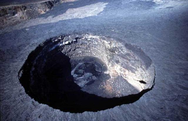 |
Figure 8. Aerial photograph looking down into the southern crater of Erta Ale. The crater is about 145 m in diameter, with an active lava lake. Courtesy of L. Cantamessa, Géo-Découverte. |
Observations during 29-30 January 2001. An expedition sponsored by Aventure et Volcansmade crater observations for 48 hours during 29-30 January 2001. Because of the extremely dry and hot climate that prevails in this region, smoke or vapor rarely obscured visual observations. The N crater exhibited only fumarolic activity, but due to thick fumes from its southern portion, gas masks were necessary for those who climbed into the crater.
The S crater was determined to be ~170 x 130 m, with the active lava lake (figure 9) on the W side having a diameter of ~121 m. The lava lake was located, based on GPS measurements, at 13° 36' 11" N, 40° 39' 49" E. Cyclic activity, approximately every 4 hours, consisted of the thin, dark crust on the lake surface splitting and causing a "fantastic" bubbling of the liquid lava across the entire ~12,000 m2 of the lake surface. Vigorous degassing created lava fountains 10-20 m high. Several times local collapses were seen which mainly affected the vertical walls in the SE part of the crater. The level of the lava lake remained stable.
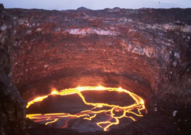 |
Figure 9. Evening photograph showing the active lava lake in the southern crater of Erta Ale during 29-30 January 2001. Molten lava can be seen around the edges and through fractures in the cooled surface of the lake. Courtesy of Guy de Saint-Cyr, Aventure et Volcans. |
Observations during 13-18 February 2001. Between 13 and 18 February 2001 two groups from the Société de Volcanologie (SVG), in an expedition organized by Géo-Découverte, reached the volcano by land and by helicopter (3 days later). The principal topographic elements in the N part of the caldera were the subject of GPS and telemetric measurements. The active S crater contained an elliptical lake (80 x 100 m) with a surface level 80 m below the rim and lava fountains rising 5-10 m high.
The relative absence of gas in the active crater allowed excellent observations. Over a period of 14 hours, Yves Bessard and Alain de Chambrier recorded details of the activity occurring at the lava lake, including lake movements and lava fountains. The surface of the lake was renewed approximately every 10 minutes. A continuous video recording over a period of 77 minutes was also taken from the edge of the lava lake at the bottom of the crater.
Systematic measurements of fumarole temperatures were made, primarily on the edge of the N crater and the external N edge of the caldera; values ranged from 60°C to more than 260°C at the strongly active N-crater fumaroles.
The last previous thermal measurements at Erta Ale were carried out in the 1970s by a team led by Haroun Tazieff; the most recent temperatures reported in the literature were obtained from infra-red satellite data (work mainly carried out by Oppenheimer, Francis, and Rothery). The thermal measurements collected by Marc Caillet, Steven Haefeli, and Pierre-Yves Burgi during 13-15 February 2001 are summarized below; more details on this fieldwork will be published in a journal paper.
The SVG team used a pyrometer, which works by remotely measuring the infrared radiations emitted by the lava, for the temperature measurements. Temperature calculations need an emissivity factor, the determination of which required an approach to the lava lake. For the temperature measurement of the crust, the only accessible part of the lake, the following protocol was followed. Using a steel wire, a steel sheet of 18 x 18 cm (8 mm thickness) containing a hole in which the thermocouple was inserted was deposited on the crust of the lake. Because of the distance separating the terrace from the lake (estimated at 15 m), this required the coordination of three people (Marc Caillet, Steven Haefeli, and Pierre-Yves Burgi). Caillet, standing where the ambient temperature reached 300°C, was equipped with a reflective cloth and used a large 8-m steel pole to move the thermocouple away from the wall.
Once the steel sheet was in contact with the lake's crust, temperature measurements were carried out every 30 seconds for 10 minutes, then each minute during the next 20 minutes, until the temperature stabilized. The temperature recorded at this time was 350°C. A pyrometric measurement in the same area of the thermocouple indicated a temperature of 342°C (with an emissivity index set to 0.9 on the pyrometer). By combining the temperatures obtained with the thermocouple and the pyrometer, and knowing the wavelength used by the pyrometer, an emissivity factor of 0.74 was determined. By collecting a sample of basalt, it was possible to confirm this value by the use of a furnace.
Acquisition of temperatures at various lake locations was carried out by pyrometry. Continuous pyrometric measurements were taken over periods of several tens of minutes (with a measurement each second) and were collected on a portable computer. The crust, many faults, and lava fountains were the three types of areas considered. These measurements were made from the edge of the pit and from the lower terrace. The measurements made near the lake were of primary importance because both the absorption of radiation by magmatic gases between the source and the observer and the enlarging of the pyrometer field of view with distance are two factors which tend to distort measurements. A difference of about 25°C was observed between the maxima measured from the edge and the bottom of the pit. In addition, the temperature measurements were taken at night in order to avoid any pollution due to the solar radiation (which can distort values up to 90%). The highest recorded temperature, 1,217°C, was found in a lava fountain. The temperature of the crust of the lake was very variable, 290°C near the cliffs to 520°C in the center of the lake, with an average of 474°C.
Geological Summary. The Erta Ale basaltic shield volcano in Ethiopia has a 50-km-wide edifice that rises more than 600 m from below sea level in the Danakil depression. The volcano includes a 0.7 x 1.6 km summit crater hosting steep-sided pit craters. Another larger 1.8 x 3.1 km wide depression elongated parallel to the trend of the Erta Ale range is located SE of the summit and is bounded by curvilinear fault scarps on the SE side. Basaltic lava flows from these fissures have poured into the caldera and locally overflowed its rim. The summit caldera usually also holds at least one long-term lava lake that has been active since at least 1967, and possibly since 1906. Recent fissure eruptions have occurred on the N flank.
Information Contacts: Luigi Cantamessa, Geó-Découverte, 12-14 rue de Cendrier, CH-1201 Geneva, Switzerland (URL: http://geo-decouverte.ch/); Annie Buard, Christophe Toussaint, Jean Claude Boissonnet, Philippe Roy, and Guy de Saint-Cyr, Aventure et Volcans, 73 cours de la Liberté, 69003 Lyon, France; P. Vetsch, Marc Caillet, Steven Haefeli, and Pierre-Yves Burgi, Société de Volcanologie (SVG), PO Box 6423, CH-1211 Geneva 6, Switzerland (URL: http://www.volcan.ch/).