Report on Chikurachki (Russia) — January 2002
Bulletin of the Global Volcanism Network, vol. 27, no. 1 (January 2002)
Managing Editor: Richard Wunderman.
Chikurachki (Russia) Several January-February ash clouds observed; small crater formed
Please cite this report as:
Global Volcanism Program, 2002. Report on Chikurachki (Russia) (Wunderman, R., ed.). Bulletin of the Global Volcanism Network, 27:1. Smithsonian Institution. https://doi.org/10.5479/si.GVP.BGVN200201-290360
Chikurachki
Russia
50.324°N, 155.461°E; summit elev. 1781 m
All times are local (unless otherwise noted)
The last report of volcanism at Chikurachki on Paramushir Island in the northern Kuriles (figure 3) was made by crews on fishing boats near the volcano on 19 November 1986; activity consisted of lava flows, ash clouds, and pyroclastic flows (SEAN 11:11, 11:12, and 12:01). Chikurachki is not seismically monitored, and therefore the Kamchatka Volcanic Eruptions Response Team (KVERT) does not use a Color Concern Code to label the level of activity. The volcano is not visible from the closest town from which KVERT receives ashfall reports from, Severo-Kurilsk (~55 km NE of the volcano). Information about volcanism comes from crews on vessels and pilots passing Paramushir Island.
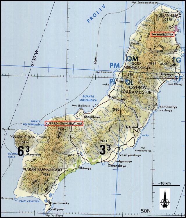 |
Figure 3. Map of Paramushir Island showing Chikurachki volcano on the SW part of the island, Fuss Peak volcano forming a peninsula to the SW, Ebeko volcano at the N end of the island, and the town of Severo-Kurilsk on the NE side of the island. This map is a segment from the Tactical Pilotage Chart E-10C of the NOAA Sectional Aeronautical Chart Series. Compiled in October 1984 by the Defense Mapping Agency Aerospace Center. Courtesy of NOAA. |
An eruption began at Chikurachki on 25 January. The start time of the eruption is not known, but between 1200 and 1500 ash fell to the NE in Severo-Kurilsk. The ash mixed with snow and formed a layer ~1.5 mm thick; the thickness of the ash alone was probably ~10-30% less. On 2 February an eruption was seen by a helicopter pilot. At 1200 that day an ash column rose 300 m above the volcano's crater and drifted more than 70 km to the SE.
The next report of volcanism at Chikurachki was made by a hunter on 7 February. He heard thunder and saw a persistent ash column rising to ~2.5 km altitude. The upper portion of the ash cloud was obscured by low cloud cover, so the ash cloud's exact height and direction of movement were not known.
Reports of activity at Chikurachki also prompted news reports stating that Ebeko, ~60 km NE of Chikurachki, was erupting (figure 3). The reports were found to be false; Chikurachki was the only volcano on Paramushir Island to be active in January.
According to reports from Severo-Kurilsk, by mid-February volcanism at Chikurachki had decreased. Visual observations from a helicopter on 18 February revealed that a small new crater had formed on the SSE part of the volcano's summit crater. In addition, a gas-and-steam plume rose 150 m above the crater and extended to the ESE. A stripe of fresh ash was seen on the volcano's E slope. A satellite image, taken on 18 February at 1649, provided a relatively clear view of Chikurachki; no thermal anomaly or volcanic plume was visible. Although the level of volcanic activity decreased, KVERT stated that ash explosions could still occur. According to the Tokyo VAAC, possible eruptions on 21 February at 0325 and 24 February at 1232 may have produced ash clouds that rose to ~6 and 5.8 km, respectively.
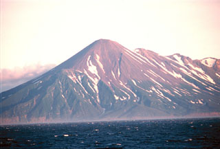
Geological Summary. Chikurachki, the highest volcano on Paramushir Island in the northern Kuriles, is a relatively small cone constructed on a high Pleistocene edifice. Oxidized basaltic-to-andesitic scoria deposits covering the upper part of the young cone give it a distinctive red color. Frequent basaltic Plinian eruptions have occurred during the Holocene. Lava flows have reached the sea and formed capes on the NW coast; several young lava flows are also present on the E flank beneath a scoria deposit. The Tatarinov group of six volcanic centers is located immediately to the south, and the Lomonosov cinder cone group, the source of an early Holocene lava flow that reached the saddle between it and Fuss Peak to the west, lies at the southern end of the N-S-trending Chikurachki-Tatarinov complex. In contrast to the frequently active Chikurachki, the Tatarinov centers are extensively modified by erosion and have a more complex structure. Tephrochronology gives evidence of an eruption around 1690 CE from Tatarinov, although its southern cone contains a sulfur-encrusted crater with fumaroles that were active along the margin of a crater lake until 1959.
Information Contacts: Olga Chubarova, Kamchatka Volcanic Eruptions Response Team (KVERT); Thomas P. Miller, Alaska Volcano Observatory (AVO), 4200 University Drive, Anchorage, AK 99508, USA (URL: http://www.avo.alaska.edu/); Tokyo Volcanic Ash Advisory Center, Tokyo, Japan (URL: http://ds.data.jma.go.jp/svd/vaac/data/); National Oceanic and Air Administration (NOAA), 14th Street & Constitution Avenue, NW, Room 6013, Washington, DC 20230 (URL: http://www.noaa.gov).