Report on Pacaya (Guatemala) — March 2002

Bulletin of the Global Volcanism Network, vol. 27, no. 3 (March 2002)
Managing Editor: Richard Wunderman.
Pacaya (Guatemala) Costly 1999 aircraft-ash encounters due to ash plumes
Please cite this report as:
Global Volcanism Program, 2002. Report on Pacaya (Guatemala) (Wunderman, R., ed.). Bulletin of the Global Volcanism Network, 27:3. Smithsonian Institution. https://doi.org/10.5479/si.GVP.BGVN200203-342110
Pacaya
Guatemala
14.382°N, 90.601°W; summit elev. 2569 m
All times are local (unless otherwise noted)
At least two commercial aircraft flew through airborne ash near the Guatemala City airport on 21 May 1999. An eruption from Fuego that day was the first at that volcano since 1987 (BGVN 24:04). Although the aviator's reports attributed the ash from this encounter to Fuego, their aircraft intersected multiple ash plumes in widely different locations, and thus they may also have crossed plumes from Pacaya. The most likely plume near the southern approach to the airport (La Aurora, ~23 km N of Pacaya; ~40 km NE of Fuego) is from the almost constantly active Pacaya. In contrast, Fuego lies 32 km W of Pacaya and was the likely source of a plume intersected later during the flight, at higher altitude, and for much longer duration.
During the encounters the ~100 or more people on board the two aircraft, and many more on the ground, were at risk. Both encounters seriously damaged the aircraft but ended in safe landings without reported injuries. Volcanic ash can cause jet-engine failure, which creates a hazard not only to passengers, but to people on the ground as well. The risk in this situation was amplified by the airport's proximity to urban Guatemala City (population, >1.1 million).
This example leads to two conclusions discussed further below. First, ash avoidance methodology needs further refinement. Second, there exists an apparent bias towards under-reporting of aircraft-ash encounters, which could short-change their cost to air carriers, their perceived risk, and their funding allocation.
The original report of an aircraft-ash encounter was brought to our attention by Captain Edward Miller of the Air Line Pilots Association and provided on the condition that the air carrier remain anonymous. Bulletin editors also wish to acknowledge conversations with several additional anonymous contacts (commercial pilots). This case occurred in Guatemala; however, analogous situations exist at many airports adjacent to volcanoes. Modest eruptions from nearby volcanoes may be uncertain or difficult to see; they may be hard to detect or characterize; yet they still may yield mobile ash plumes carried by complex local winds to confront air traffic (Salinas, 2001; Hefter, 1998; Casadevall, 1994).
Although in most Bulletin reports we favor the use of local time to emphasize the reference frame of people on the scene, most of the source material (satellite and aviation) for this report refer to UTC (Coordinated Universal Time). UTC is the time on the Greenwich meridian (longitude zero), formerly GMT, a term which has fallen out of use. Accordingly, there are cases in this report that lack conversion to local time. Local time in Guatemala is 6 hours behind UTC.
Activity at Fuego and Pacaya. Fuego erupted on 21 May 1999 sending ash to the S, SE, and SW and ultimately dropping up to 40 cm of ash on local settlements (BGVN 24:04). The eruption occurred at 1800 local time (in terms of UTC, at 0000 the next day). Three hours later the eruption decreased and the Aeronautica Civil recommended that planes go no closer to Fuego than 40 km. One hour after that (at 2200 local, 0400 UTC), the atmospheric ash had settled, and Aeronautica Civil recommended flying no closer to Fuego than 15 km.
Bulletin reports for Pacaya in mid-1999 suggested relative calm, in harmony with the observation that it had chiefly been fuming. However, Pacaya is well-known for Strombolian outbursts. It lies directly in-line and only 23 km S of the N10°E-oriented airstrip. As is common for commercial aircraft there, the approaches described below passed very close to Pacaya. Pacaya typically has lower and smaller eruptions than Fuego, but because it lies so close to the southern approach to the airport, Pacaya's ash plumes easily enter the path of landing aircraft. The situation was particularly complex during this eruption because Fuego's ash was reported on cities that lie below the flight path as well as on the Pacaya's flanks.
Pilot's report of aircraft-ash encounter. What follows was taken from one flight crew's description of events and from later reports and dialog on the topic. In order to preserve the confidentiality of the airlines, the precise times of events on 21 May 1999 have been omitted. Pilots reported clear visibility and light wind, with both the capital and the airport in sight. They maneuvered the aircraft for a final approach from the S. Pilots were advised by air traffic control about erupted particulate ("volcanic sand") about 24 km (15 miles) SE of the airport, well away from their projected path to Runway 01. In addition, based on winds they detected as they neared the airport, the pilots concluded that the erupted particulate to the SE was downwind from their projected flight path to the airport. (In retrospect, this conclusion appears tenuous considering the possibility of either a fresh injection of ash from Fuego, or lingering ash in the trailing portion of the plume that lay to the SE.)
At ~32 km (20 miles) distance from the runway, the pilots maneuvered the plane through ~3,000 m (9,700 feet) altitude on a final approach to the airport with the plane's flaps partially extended (at ~15°, which slowed their aircraft to ~260 km/hour (160 mph), its auxiliary power unit (a small jet engine) on, and its landing gear down. Around this point in their descent, pilots saw bright yellow sparks through the windshield lasting a few seconds, a display unlike static electricity, but rather like that from a grinding wheel. This occurred again at 2,500 m (8,200 feet) altitude, but was more intense yet intermittent.
At this time, air-traffic control announced to the pilots that the aircraft landing in front of them had encountered volcanic particulate; they instructed the pilots to abort their landing and climb to 3,350 m (11,000 feet) altitude. Discussions of options and ash avoidance ensued between pilots and air-traffic control; ash had by this time accumulated on the runway, further complicating landing, even for approaches in the opposite direction. The pilots retracted the landing gear, accelerated to ~410 km/hour (~250 mph), began to climb, and after some discussion with air-traffic control, held on a course NE of the airport. They were subsequently cleared to climb to 6,700 m (22,000 feet) altitude and advised to proceed to an alternate airfield.
During the climb, at ~5,800 m (19,000 feet) altitude en-route to the alternate airport, the aircraft encountered volcanic particulate for 10 minutes. Within that interval the plane spent 2 minutes during ascent engulfed in denser and heavier particulate. During that period, window arcing was constant and the beam of their landing lights revealed a conspicuous cloud of reflecting particles. During ash ingestion the engines's speed lacked noticeable fluctuations. The aircraft exited the plume at about 6,100 m (20,000 feet) altitude and landed without encountering additional ash.
Upon landing, the pilots noticed reduced visibility through abraded windshields. Post-flight examination of the airplane revealed heavy damage, requiring the replacement of the engines (US $2 million each) and auxiliary-power-unit engine. (Note, however, that no deterioration in engine power or performance was noticed during the flight.) Other replaced parts included windshields, a heat exchanger, and coalescer bags. Minor damage was seen on the horizontal stabilizer and wing leading-edges.
Volcanic Ash Advisory Statements. The U.S. National Oceanic and Atmospheric Administration (NOAA), Satellite Services Division website contains two archived statements issued by the Volcanic Ash Advisory Center (VAAC) at Washington, D.C. for Fuego on 21-22 May 1999. The statements, issued to the aviation cummunity to warn of volcanic hazards, are intended for an audience accustomed to special terminology (figures 31 and 32). In the interest of advancing understanding of how volcanological and atmospheric data get transmitted to aviators, we offer brief explanations for many of the terms used (figure 31).
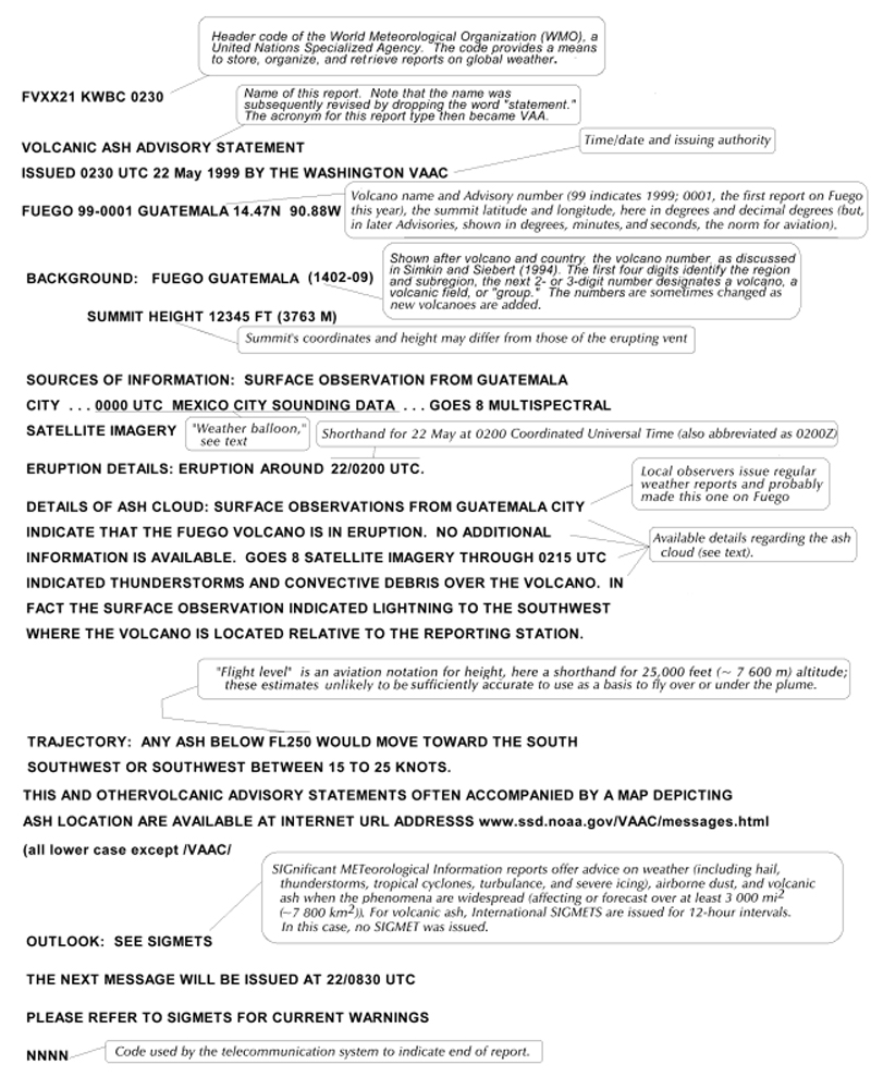 |
Figure 31. The first archived Volcanic Ash Advisory Statement (VAAS) for the 21 May 1999 eruption at Fuego, Guatemala. The boxes contain added notes to explain some of the basic conventions and specific details seen here. This Statement currently appears on the NOAA Satellite Services Division website (see "Information Contacts," below). Local names are frequently anglicized, dropping all accents and other non-English characters (eg. México would be written MEXICO). Later Advisories adopted the abbreviation "Z" (pronounced 'Zulu' by aviators) for UTC, as in 1300 UTC written as 1300Z. |
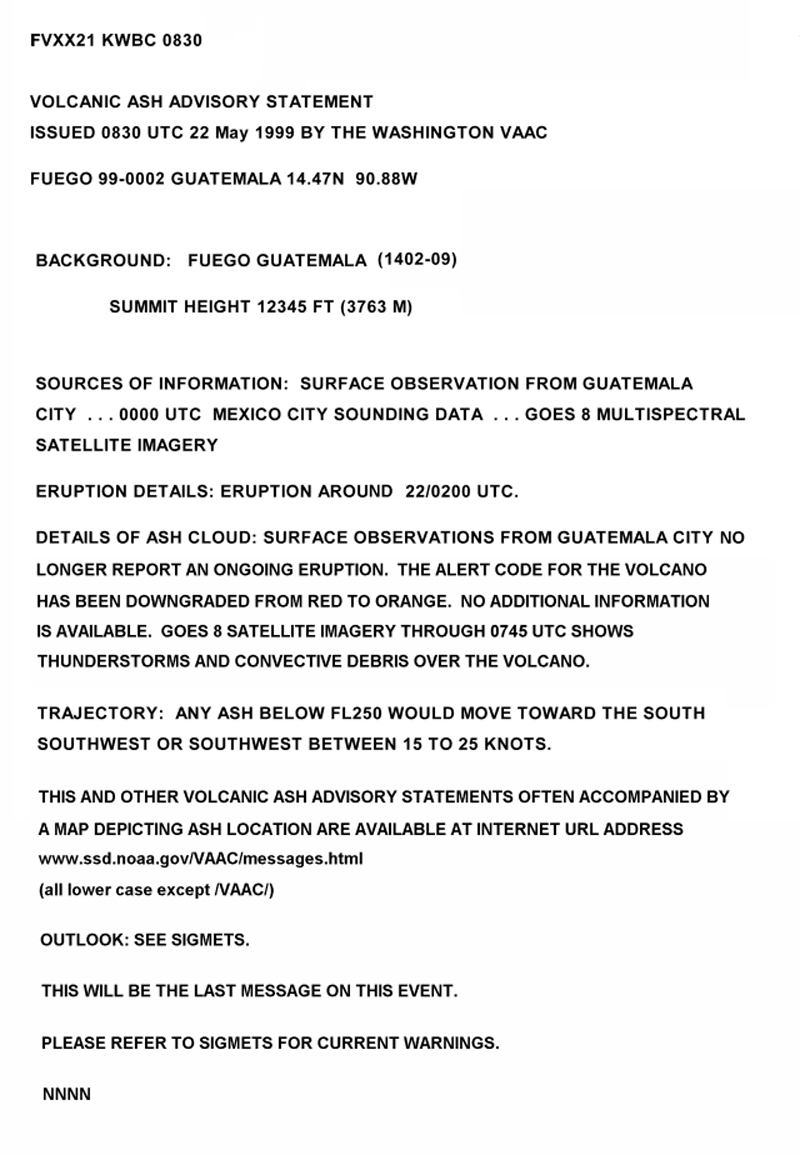 |
Figure 32. A later Volcanic Ash Advisory Statement (VAAS) for the 21 May 1999 eruption at Fuego, Guatemala. The statement, which was issued the next day, discloses that the eruption had then stopped and the hazard status was lowered. The statement appears on the NOAA Satellite Services Division website (see "Information Contacts," below). |
The Washington VAAC received first notification of the Fuego eruption from a routine surface weather observation from Guatemala City at 2000 local time (0200 UTC) on 22 May. They issued the first Volcanic Ash Advisory Statement a half-hour later (figure 31). Six hours later they issued the second Advisory Statement (figure 32). The Advisories were composed by staff of the Satellite Analysis Branch, one of the two NOAA components forming the Washington VAAC (Streett, 1999; Washington VAAC).
The section "Details of ash cloud" first says that the "surface observation from Guatemala City indicate that the Fuego volcano is in eruption" and that no additional information is available and then briefly describes in words observations that came from satellite imagery. The first sentence, "No eruption..." is self-explanatory, but highlights a limitation of the method in use that needs to be emphasized to aviators: an eruption may have occurred but its status is not revealed on the imagery. The sentence, "No eruption could be detected due to thunderstorm cloudiness covering the area around the volcano" is self-explanatory. Less clear is the term convective debris. It does not refer to ash; rather, it refers to remnants of thunderstorms. The gist of these latter two sentences is simply that the thunderstorms that covered the area made it challenging or impossible to see the ash on satellite imagery. Central American thunderstorm clouds typically can reach altitudes of more than 12,000 m (40,000 feet), and can mask or obscure airborne ash residing below that level.
Members of the Washington VAAC commented that this eruption demonstrates key problems that can arise when cloudy conditions prevent satellite detection of ash, foiling a primary mode of analysis. In such cases, they rely on ground observers (including observatories and weather observers), pilot reports, and reports from airlines. Thus, their ability to issue useful information in cloudy conditions depends on the quality of communications with local observers, the Meteorological Watch Office, volcanologists, geophysical observatories, and the aviation community.
The Advisory Statement listed México City weather balloon data acquired 1,050 km NW of Guatemala City. In retrospect, the Washington VAAC noted that they generally avoid using such distant sounding data. If a closer sounding cannot be found, they prefer to use upper-level wind forecasts taken from a numerical weather model. In any case, the scarcity of local sounding data presents a challenge to the realistic analysis of airborne ash.
The outlook section says to "see SIGMETS." SIGMETS are the true warnings to aircraft for SIGnificant METeorological events. They are issued by regional Meteorological Watch Offices (MWOs), in this case the MWO (for Guatemala) is in Tegucigalpa, Honduras. SIGMETS were lacking for this eruption; although the Washington VAAC tried to contact the MWO without response. Another complexity confronted at the VAAC is a lack of a single scale for communicating a volcano's hazard status.
Reporting of aviation ash encounters. In personal communications with Bulletin editors, airline personnel stated that many more encounters have occurred than have yet been tallied in publically accessible literature. In accord with those assertions, the 21 May 1999 encounters are absent from reports compiled by the International Civil Aviation Organization (ICAO, 2001). In that document (Appendix I, table 3A, p. I-12) Fuego fails to appear as a source vent for any aircraft-ash encounter. Pacaya is listed for two encounters, in January 1987 and in May 1998 (BGVN 23:05).
Even though the number of encounters was probably under-represented and thus reflects a minimum, ICAO (2001) notes that the international costs to aviation since 1982 summed to well in excess of $250 million. They noted, "In addition to its potential to cause a major aircraft accident, the economic cost of volcanic ash to international civil aviation is staggering. This involves numerous complete engine changes, engine overhauls, airframe refurbishing... aircraft downtime... [and] volcanic ash clearance from airports and the damage caused to equipment and buildings on the ground."
The incidents here suggest that there has been a strong bias toward under-reporting aircraft-ash encounters. If this tentative conclusion is correct, it implies consistent understatements of the hazard's magnitude. This, in turn, may have thwarted meaningful analysis of how and whether to proceed with designing more robust hazard-reduction systems. Accordingly, resources that could have been devoted to the problem have not yet been committed (see Gimmestad and others, 2001 for a discussion of a prototype on-board ash-detection instrument).
Communication challenges. While much of the aviation community needs to learn about volcanism rapidly, dependably, and with the aid of the Internet, some observers charged with reporting volcanic-ash hazards in Central and South America lack access to basic communication devices like reliable telephones and fax machines. To reduce the risks, the aviation, meteorological, remote sensing, and volcanological communities need to improve their ability to pass critical information to each other rapidly and precisely. The operational systems related to volcanic ash and aviation must transcend numerous boundaries (eg., languages, infrastructure, funding, governments, agencies, air carriers, pilots, aircraft manufactures, etc.). The systems need to portray complex, dynamic processes such as the rapid rise of an explosive plume, or large-scale ash-cloud movement.
Although the infrastructure for ash avoidance is greater than ever, members of the Washington VAAC have told Bulletin editors that they still depend heavily on people on the scene of the eruption to notify them promptly when eruptions occur. They said that thus far in parts of Central and South America a problem has been the expense of communication (eg., by phone, fax, and Internet). They also said that for the same regions the U.S. meteorological database regularly lacks pilot reports. Though serious, these problems have at least been identified and their solutions would appear to lack great technical or economic barriers.
The pilots involved in the May 1999 encounter recommended that far more emphasis be placed on forecasting and avoiding ash plumes. Other pilots cited the need for fast and accurate communications between those who observe eruptive activity and air traffic control personnel.
Issues like these continue to be an important subject at gatherings on the topic of ash hazards in aviation (Casadevall, 1994; Streett, D., 1999; Washington VAAC, 1999). The Airline Dispatcher's Federation (ADF) will participate in a 7-9 May 2002 conference and workshop: "Operational Implications of Airborne Volcanic Ash: Detection, Avoidance, and Mitigation." The gathering will provide the pilot and dispatcher with insights into volcanic ash, including its characteristics, affects on aircraft, detection/tracking, effective warning systems, and mitigation. A "hands-on" exercise will make this the first gathering of its kind to provide lab-style instruction on interpretation of satellite and wind data, and on models of ash trajectory and dispersion. Representatives from the Boeing company, and a host of US government agencies and non-governmental organizations will attend. The workshop will include lectures, demonstrations, laboratory exercises, and a simulated-eruption exercise involving volcanologists, forecasters, controllers, dispatchers, and pilots.
A second international symposium on ash and aviation safety is being planned by the U.S. Geological Survey, organized by Marianne Guffanti. It will be held in Washington, D.C. in September 2003.
References. Casadevall, T.J. (ed.), 1994, Proceedings of the First International Symposium on Volcanic Ash and Aviation Safety: U.S. Geological Survey Bulletin 2047, 450 p.
Gimmestad, G.G., Papanicolopoulos, C.D., Richards, M.A., Sherman, D.L., and West, L.L., 2001, Feasibility study of radiometry for airborne detection of aviation hazards, NASA/CR-2001-210855; Georgia Tech Research Institute, Atlanta, Georgia, 51 p. (URL: http://techreports.larc.nasa.gov/ltrs/PDF/2001/cr/).
Hefter, J.L., 1998, Verifying a volcanic ash forecasting model, Airline Pilot, v. 67, no. 5, pp. 20-23, 54.
International Civil Aviation Organization (ICAO), 2001, Manual on volcanic ash, radioactive material, and toxic chemical clouds, doc 9691-AN/954 (first edition): 999 University St., Montreal, Quebec, Canada H3C 5H7 (purchasing information: sales_unit@icao.int).
Rose, W.I., Bluth, J.S.G., Schneider, D.L., Ernst, G.G.J., Riley, C.M., Henderson, L.J., and McGimsey, R.G., 2001, Observations of volcanic clouds in the first few days of atmospheric residence: The 1992 eruptions of Crater Peak, Mount Spurr volcano, Alaska, Jour. of Geology, v. 109, p. 677-694.
Salinas, Leonard J., 2001, Volcanic ash clouds pose a real threat to aircraft safety: United Airlines, Chicago, Illinois (URL: http://www.dispatcher.org/library/VolcanicAsh.htm).
Simkin, T., and Siebert, L., 1994, Volcanoes of the World, 2nd edition: Geoscience Press in association with the Smithsonian Institution Global Volcanism Program, Tucson AZ, 368 p.
Streett, D., 1999, Satellite-based Volcanic Ash Advisories and an Ash Trajectory Model from the Washington VAAC: Eighth Conference on Aviation, Range, and Aerospace Meteorology, 10-15 January 1999, Dallas, Texas; American Meteorological Society, p. 290-294.
Washington VAAC, 1999, Operations of the Washington Volcanic Ash Advisory Center, in Aeronautical meteorological offices and their functions, and meteorological observation networks: Third Caribbean/South American Regional Air Navigation Meeting (Car/sam/ran/3); Buenos Aires, Argentina, 5 - 15 October, 1999; International Civil Aviation Organization (http://www.ssd.noaa.gov/ VAAC/PAPERS/carsam.html).
Geological Summary. Eruptions from Pacaya are frequently visible from Guatemala City, the nation's capital. This complex basaltic volcano was constructed just outside the southern topographic rim of the 14 x 16 km Pleistocene Amatitlán caldera. A cluster of dacitic lava domes occupies the southern caldera floor. The post-caldera Pacaya massif includes the older Pacaya Viejo and Cerro Grande stratovolcanoes and the currently active Mackenney stratovolcano. Collapse of Pacaya Viejo between 600 and 1,500 years ago produced a debris-avalanche deposit that extends 25 km onto the Pacific coastal plain and left an arcuate scarp inside which the modern Pacaya volcano (Mackenney cone) grew. The NW-flank Cerro Chino crater was last active in the 19th century. During the past several decades, activity has consisted of frequent Strombolian eruptions with intermittent lava flow extrusion that has partially filled in the caldera moat and covered the flanks of Mackenney cone, punctuated by occasional larger explosive eruptions that partially destroy the summit.
Information Contacts: Captain Edward Miller, Air Line Pilots Association (ALPA), Air Safety & Engineering Department, 535 Herndon Parkway, PO Box 1169, Herndon, VA 22070-1169, USA; Grace Swanson and Davida Streett, Washington VAAC, Satellite Analysis Branch (NOAA/NESDIS), 4700 Silver Hill Road, Stop 9910, Washington, DC 20233-9910, USA (URL: http://www.ssd.noaa.gov/); Bill Rose, Geological Engineering and Sciences, Michigan Technological University, Houghton, MI 49931, USA.